Download
1 / 10
100 likes | 215 Views
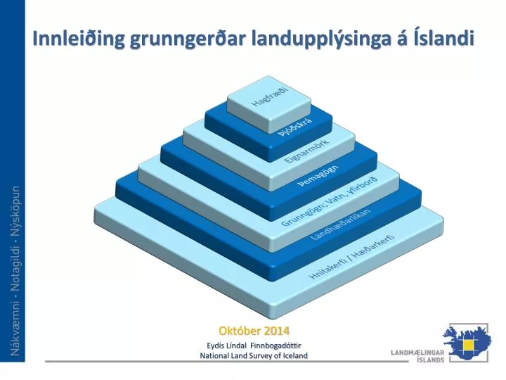
Hagfræði. Þjóðskrá. Eignarmörk. Þemagögn. Grunngögn ; Vatn , yfirborð. Landhæðarlíkan. Hnitakerfi / Hæðarkerfi. Innleiðing grunngerðar landupplýsinga á Íslandi. Október 2014. Eydís Líndal Finnbogadóttir National Land Survey of Iceland. Status. Human resources

E N D
Hagfræði Þjóðskrá Eignarmörk Þemagögn Grunngögn; Vatn, yfirborð Landhæðarlíkan Hnitakerfi / Hæðarkerfi Innleiðing grunngerðar landupplýsinga á Íslandi Október 2014 Eydís Líndal Finnbogadóttir National Land Survey of Iceland
Status Human resources NLSI, Each public partners holding GI data Financial resources Grant from state, Grant from e-government Metadata In National discovery services Tools Arctic Geoportal Standards, National IST 120, INSPIRE Policies Free data policy, National information policies Users EU, EEA, Icelandic public partners Geographical Data Fom about 50 institutes and 75 municip. Maintain Each country and data provider Acquire Distribute Process Preserve
Verkefni framundan hjá LMÍ • Innanhúsvinna hjá LMÍ : • Skoða aðra möguleika með landupplýsingagáttina • Taka ákvarðanir varðandi IS 50V í tengslum við INSPIRE • Gera view og discovery þjónusturnar INSPIRE tækar • Halda námskeið í skráningu lýsigagna • Vinna að ID málum og nafnasetningu Gagna • Klára vörpun gagna yfir á INSPIRE form / eENVplus • Fylgjast með breytingum innan INSPIRE s.s. MIG
Vatnafar Landmælingar Íslands Water lines and poligons Waterfalls poins Placenames rel. to water Veðurstofa Íslands Flow lines, water bodies, Flow and temperatue Orkustofnun Use of resources Veiðimálastofnun Water researches Water Matvælastofnun Drinking water Umhverfisstofnun Nature conservation Water quality Water framworke Skipulagsstofnun / sveitarfélög Use of water