Download
1 / 16
160 likes | 283 Views
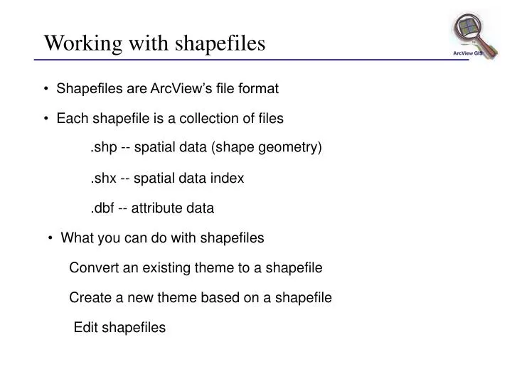
Shapefiles are ArcView’s file format. Each shapefile is a collection of files. .shp -- spatial data (shape geometry). .shx -- spatial data index. .dbf -- attribute data. What you can do with shapefiles. Convert an existing theme to a shapefile. Create a new theme based on a shapefile.

E N D
Shapefiles are ArcView’s file format • Each shapefile is a collection of files .shp -- spatial data (shape geometry) .shx -- spatial data index .dbf -- attribute data • What you can do with shapefiles Convert an existing theme to a shapefile Create a new theme based on a shapefile Edit shapefiles Working with shapefiles
Create new theme and specify feature type • Name the theme Creating a new shape theme
Creating a new shape theme • Shape theme is added to the view • New theme is active and ready for editing
Point Line Multiline Rectangle Circle Polygon Line split Polygon split AutoComplete Adding shape theme features • Use the Draw tool to create new features
New theme table 1 record for each feature • Add values Adding attributes • Add fields
During an edit session Save Edits Save Edits As • After edits are completed Stop Editing Start editing another theme Save Project Exit Saving your edits
Modify features Union Combine Intersect Subtract Editing shapefiles • Start/Stop Editing • Select features • Reshape features • Snap features • Split features
Editing polygon themes • Delete polygon features • Cut and paste polygon features • Move polygon features • Resize polygon features • Reshape polygon features • Split polygon features • Merge polygon features • Create doughnut polygons • Remove area of overlap between polygons • Obtain the intersection of polygons
Reshape a single polygon Click inside polygon Click to add vertex Drag to move a vertex Drag to move a vertex Click on common boundary Click to add a vertex Reshaping features • Reshape a common boundary
Snapping features • Connects features or vertices to existing features or vertices • Two types of snapping: • General snapping • Interactive snapping
By typing a tolerance - Turn snapping on - Specify distance • Using the mouse (Click the right mouse button) Setting snapping
Single line Split New lines (4) New polygons (2) Single polygon Split Splitting lines and polygons
Set Split rule for each field • Before split • After split Updating attributes with Split
Adjacent polygons • Non-adjacent polygons • Overlapping polygons 2 polygons, 2 records 2 polygons, 2 records 2 polygons, 2 records Merging features with Union
Set Union rule for each field • Before Union • After Union Updating attributes with Union
Combine (top) (top) (bottom) (bottom) More editing operations • Intersect • Subtract