Download
1 / 57
570 likes | 673 Views
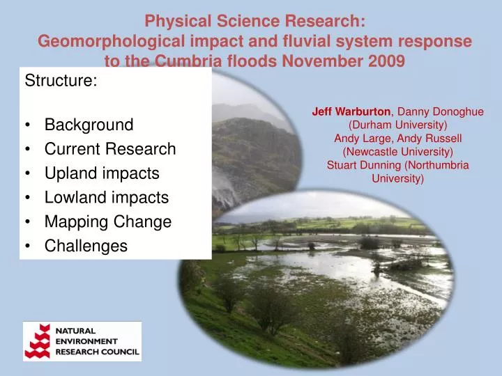
Physical Science Research: Geomorphological impact and fluvial system response to the Cumbria floods November 2009. Structure: Background Current Research Upland impacts Lowland impacts Mapping Change Challenges. Jeff Warburton , Danny Donoghue (Durham University)

E N D
Physical Science Research: Geomorphological impact and fluvial system response to the Cumbria floods November 2009 • Structure: • Background • Current Research • Upland impacts • Lowland impacts • Mapping Change • Challenges Jeff Warburton, Danny Donoghue (Durham University) Andy Large, Andy Russell (Newcastle University) Stuart Dunning (Northumbria University)
Background: Recent upland flood events Northern England January 2005 Shetland, Scotland September 2003 North York Moors, England June 2005 Northern England October 2008
Rollei ARSF NERC digital camera Valley erosion and deposits Flood extent image, 23 June 2005
Cumbria floods – ‘flood rich’ periods From: Watkins and Whyte (2008) – ‘updated’
Background – contemporary sediment budgets Dissection & Gullying Scar & Peat Margin Erosion Mass Movements & debris flows Sheet & Wash Erosion Wind Erosion UPLAND HILLSLOPE Slope Deposits Stream Course & Bank Erosion Pipe erosion Streambank LOWLAND Bedload Solute & Flotation Load Suspended Load CHANNEL Channel Sediments storage Lakes & Reservoirs process
Aim: to examine flood impacts the whole river corridor of the river Derwent from the headwaters, through Bassenthwaite Lake to the Lowland agricultural/urban catchment Objectives: Structured field inventory of the geomorphic impact on the River Derwent river corridor Provide a rapid geomorphic assessment of the role of scour and sedimentation in the river Identify areas of risk for remobilisation of flood-deposited sediments; delivery of hillslope sediments and hotspots of erosion Compare post-flood field-derived data with pre-existing surveys to quantify/ areas of greatest geomorphic change Work with stakeholders in designating catchment zones that are ‘at risk’ from erosion and sedimentation
Scale of river and catchment management (Newson, 1992)
Plan of Research: Survey headwater impacts - Coledale, Newlands and Borrowdale areas Bassenthwaite Lake - collect a series of short cores and grab samples from the Lake and compared with a survey undertaken in 2008. Lowland channel change in the floodplain downstream of Bassenthwaite Lake - focussing on ‘typical’ reaches e.g. Isel and Camerton. Support field survey with low-level high-resolution aerial surveys carried out using a UAV (Unmanned Aerial Vehicle) - provide rapid repeat, high resolution aerial imagery and Digital Elevation models of key sites (cf. larger scale ARSF and EA remote sensing data).
Upland Impacts Seathwaite, Borrowdale 2009
Mapping elements Source area 1 Runout Source area 2 Runout Debris fan
Map and sediment budget Landslide erosion 518 m3 Deposition 400 m3 Sediment loss 118 m3
Completed inventory of erosion / deposition Coledale flood 2008 Sediment deposition Slope undercutting Fan deposition Debris flow Stream deposition Torrent erosion Landslide deposition Dam pond deposition Stream erosion Surface wash Shallow landslide
Summary sediment budget (Coledale, 2008) Channel erosion 817 Landslides 183 Slope undercutting 195 933 Channel deposition Debris flows 102 92 Landslide deposits Footpath wash 97 Debris flow fans 7 7 Slope wash deposit Delivery to main fluvial system Values in t 189 14 %
Lowland Impacts Ouse Bridge & Herdwick Croft
Localised gouging and scour of cohesive flood plain sediment
Localised gouging and scour of cohesive flood plain sediment
Localised gouging and scour of cohesive flood plain sediment