Download
1 / 4
40 likes | 43 Views
In Algeria, roads necessarily cut land and divert the flow of water from their natural ways. Thus in our study area: Ouzera, before the installation of the agricultural village, the area was covered with vineyards which maintained and protected the soil cover. Currently, thinning of the surface and intensive and unsuitable cultivation practices to the severity of the landscape contribute to increased erosivity that irreversibly damages the soil. The road-level civil works, carried out in 1986-1987, created a large ravine. The effects of runoff from underground drains installed in 2000-2001 resulted in the formation of six (6) other gullies parallel to the ravine which was itself a gully. These devastate cultivated land and increase the cost of maintaining the road. Also, the evolution of the slope, densely populated (agricultural village) raises more and more questions about the future of these environments and these societies. The curbs of the road rightly worry the residents who see their fields cultivated or their meadows little by little nibbled by the flows. Also a landslide appears downstream of this village. To answer these problems, we are studying the evolution of the functioning of the ravine after the rectification of the latter realized in 2004-2005 by the conservation of the forests of the Wilaya of Medea since 1986-2017.

E N D
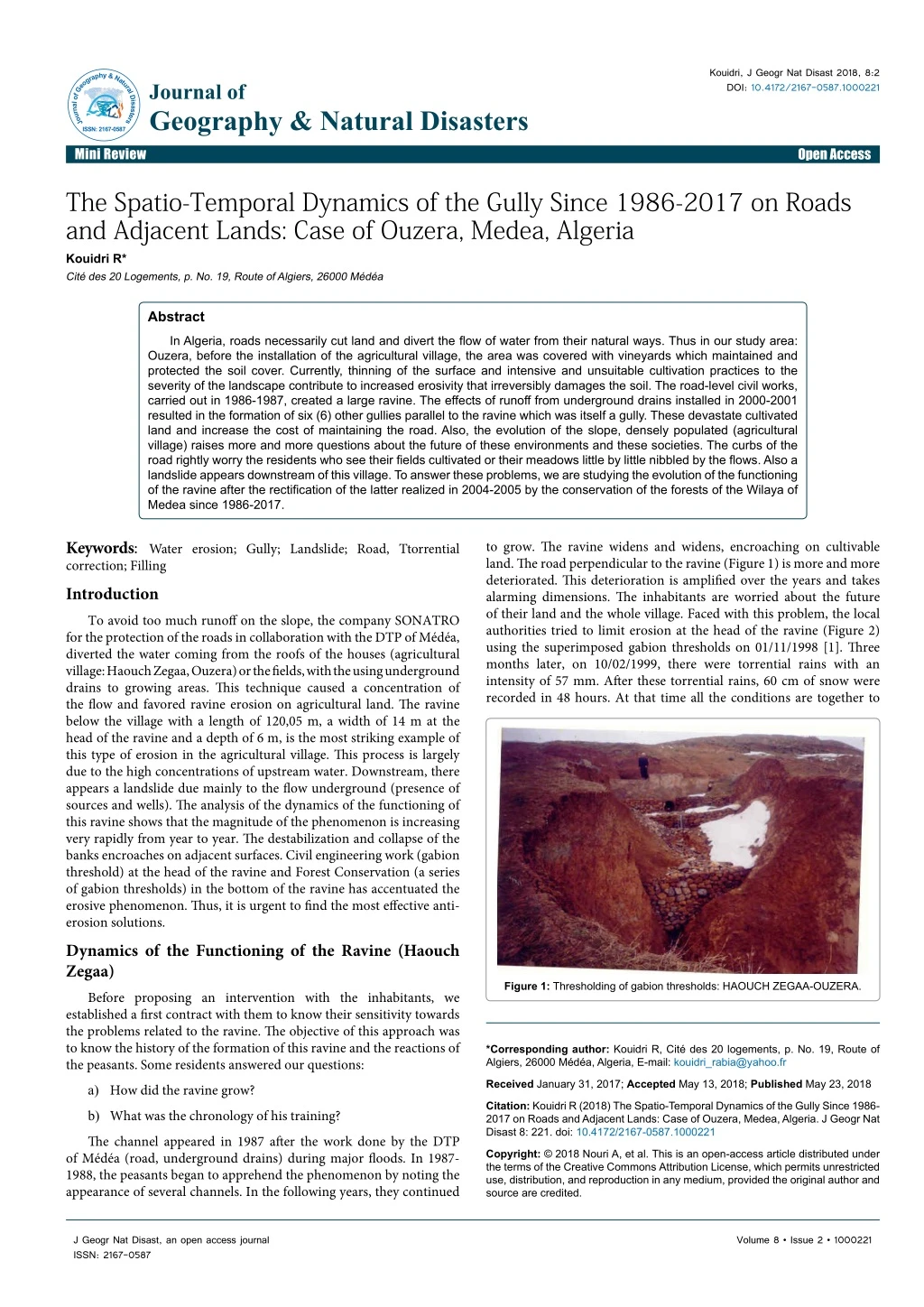
Kouidri, J Geogr Nat Disast 2018, 8:2 DOI: 10.4172/2167-0587.1000221 JournalofGeography&NaturalDisasters ISSN: 2167-0587 Journal of Geography & Natural Disasters Mini Review Open Access Research Article Open Access The Spatio-Temporal Dynamics of the Gully Since 1986-2017 on Roads and Adjacent Lands: Case of Ouzera, Medea, Algeria Kouidri R* Cité des 20 Logements, p. No. 19, Route of Algiers, 26000 Médéa Abstract In Algeria, roads necessarily cut land and divert the flow of water from their natural ways. Thus in our study area: Ouzera, before the installation of the agricultural village, the area was covered with vineyards which maintained and protected the soil cover. Currently, thinning of the surface and intensive and unsuitable cultivation practices to the severity of the landscape contribute to increased erosivity that irreversibly damages the soil. The road-level civil works, carried out in 1986-1987, created a large ravine. The effects of runoff from underground drains installed in 2000-2001 resulted in the formation of six (6) other gullies parallel to the ravine which was itself a gully. These devastate cultivated land and increase the cost of maintaining the road. Also, the evolution of the slope, densely populated (agricultural village) raises more and more questions about the future of these environments and these societies. The curbs of the road rightly worry the residents who see their fields cultivated or their meadows little by little nibbled by the flows. Also a landslide appears downstream of this village. To answer these problems, we are studying the evolution of the functioning of the ravine after the rectification of the latter realized in 2004-2005 by the conservation of the forests of the Wilaya of Medea since 1986-2017. Keywords: Water erosion; Gully; Landslide; Road, Ttorrential correction; Filling Introduction To avoid too much runoff on the slope, the company SONATRO for the protection of the roads in collaboration with the DTP of Médéa, diverted the water coming from the roofs of the houses (agricultural village: Haouch Zegaa, Ouzera) or the fields, with the using underground drains to growing areas. This technique caused a concentration of the flow and favored ravine erosion on agricultural land. The ravine below the village with a length of 120,05 m, a width of 14 m at the head of the ravine and a depth of 6 m, is the most striking example of this type of erosion in the agricultural village. This process is largely due to the high concentrations of upstream water. Downstream, there appears a landslide due mainly to the flow underground (presence of sources and wells). The analysis of the dynamics of the functioning of this ravine shows that the magnitude of the phenomenon is increasing very rapidly from year to year. The destabilization and collapse of the banks encroaches on adjacent surfaces. Civil engineering work (gabion threshold) at the head of the ravine and Forest Conservation (a series of gabion thresholds) in the bottom of the ravine has accentuated the erosive phenomenon. Thus, it is urgent to find the most effective anti- erosion solutions. Dynamics of the Functioning of the Ravine (Haouch Zegaa) Before proposing an intervention with the inhabitants, we established a first contract with them to know their sensitivity towards the problems related to the ravine.The objective of this approach was to know the history of the formation of this ravine and the reactions of the peasants.Some residents answered our questions: a) How did the ravine grow? b) What was the chronology of his training? The channel appeared in 1987 after the work done by the DTP of Médéa (road, underground drains) during major floods. In 1987- 1988, the peasants began to apprehend the phenomenon by noting the appearance of several channels. In the following years, they continued to grow. The ravine widens and widens, encroaching on cultivable land. The road perpendicular to the ravine (Figure 1) is more and more deteriorated. This deterioration is amplified over the years and takes alarming dimensions. The inhabitants are worried about the future of their land and the whole village. Faced with this problem, the local authorities tried to limit erosion at the head of the ravine (Figure 2) using the superimposed gabion thresholds on 01/11/1998 [1]. Three months later, on 10/02/1999, there were torrential rains with an intensity of 57 mm. After these torrential rains, 60 cm of snow were recorded in 48 hours. At that time all the conditions are together to Figure 1: Thresholding of gabion thresholds: HAOUCH ZEGAA-OUZERA. *Corresponding author: Kouidri R, Cité des 20 logements, p. No. 19, Route of Algiers, 26000 Médéa, Algeria, E-mail: kouidri_rabia@yahoo.fr Received January 31, 2017; Accepted May 13, 2018; Published May 23, 2018 Citation: Kouidri R (2018) The Spatio-Temporal Dynamics of the Gully Since 1986- 2017 on Roads and Adjacent Lands: Case of Ouzera, Medea, Algeria. J Geogr Nat Disast 8: 221. doi: 10.4172/2167-0587.1000221 Copyright: © 2018 Nouri A, et al. This is an open-access article distributed under the terms of the Creative Commons Attribution License, which permits unrestricted use, distribution, and reproduction in any medium, provided the original author and source are credited. J Geogr Nat Disast, an open access journal ISSN: 2167-0587 Volume 8 • Issue 2 • 1000221
Citation: Kouidri R (2018) The Spatio-Temporal Dynamics of the Gully Since 1986-2017 on Roads and Adjacent Lands: Case of Ouzera, Medea, Algeria. J Geogr Nat Disast 8: 221. doi: 10.4172/2167-0587.1000221 Page 2 of 4 Figure 2: Des pluies diluviennes se sont abattues sur la région de Ouzera. Durant 24 h, les 4, 5, 6, 7 seuils en gabion ont basculé vers l'aval après ce déluge. Figure 3: Landslide. trigger landslides. After these inclement weather and snowmelt, there was a muddy flow and a landslide at the base of the agricultural village (Figure 1). The road deteriorated, the surface of the slope became smooth, icy. The thresholds have tilted slightly. Then for 24 hours, the rains fell with an intensity of 87 mm [2]. In contrast, the gabion moved laterally 1 m 55. The second gabion moved downstream at a distance of 17 cm. These rains were certainly abundant but fell gently. The collapse of gabion thresholds (Figure 2) is mainly due to torrential rains, which had previously fallen. All the sediments coming from upstream have moved downstream from where widening of the ravine: between the flank of the right ravine and the threshold in gabion=40 cm, and between the side of the left ravine and the threshold in gabion=20 cm. The gabion thresholds have dropped by 37 cm. At the level of the first gabion threshold, there is a platform that could stall. On the other hand under the two thresholds (gabion), there exists a drain in the form of tunnel (2 m 70 cm long). Clean water from this drain pushed the sediments and large blocks below the gabion thresholds downstream. Eight months later, all the sediments left in the bottom of the ravine. On November 16, 1999, a heavy rainfall (int=28 mm) fell on this gully from which soil soaked in water. The head of the ravine has evolved a lot: sections of the flanks of this ravine break and slide along the walls partially clogging the bottom of the ravine. Since 1988, this ravine has become an outlet for the surplus water of the fields, inhabitants (roofs) of the agricultural village. Over the years, following the increase in population and land use, the flow that runs through the gully, gradually increases from its source (at the top of the village) until its discharge into the wadi. The widening of this ravine began in 1987 and has continued to the present day (according to the testimony of the peasants). This ravine has become a ravine. The monitoring of the spatio-temporal evolution of the latter began since the year 2004. In 2005, a development was carried out by the civil engineering (gabion threshold at the head of the ravine) (Figure 1) [3,4]. Landslide This slip is located below the agricultural village on the road to Kef Bou Khélil (Figure 3).The slope is constituted by marl passing to clays in certain places. Heavy rains occurred during this slip period. Part of this slope was completely overhauled on 10/03/2007 by a movement of superficial formations that slid along the slope. In this area, there are Figure 4: Ravines parallel to the ravine: Houch Zegaa Ouzera. many sources. At the base of this detachment, it is probably necessary to invoke some deformations that have prepared the ground, and also may be some withdrawals having opened crevasses where water engulfed during heavy rains of 08/03/2007.At first sight, this slope shows us a slip in packets [5]. Almost all the trees or shrubs on this slope are tilted, indicating that it is a sudden movement.Thus, in the agricultural village, the road linking Ouzera to Kef Bou Khélil poses a problem for DTP services, which have to recharge it almost every year as a result of subsidence. Deterioration of the Road The ditch along the road from Ouzera to El Djouahria has not been rebuilt in 40 years. The location of the underground drains caused this gully and deteriorated the road that is loaded each year. Thus, this ravine appeared perpendicular to the road and also other gullies parallel to the latter already studied (Figure 4).This is largely due to civil engineering works along the road. Erosion debris from this ditch along this road is deposited on good arable land [6]. Water flowing from the underground drains and the road, has dug ravines. These gullies are formed perpendicular to the road following the work done by civil engineering. These ravines are destroying the land in the Open area. They have gnawed many fields that farmers have found in the need to stop cultivating these lands which, only a few years ago, were excellent J Geogr Nat Disast, an open access journal ISSN: 2167-0587 Volume 8 • Issue 2 • 1000221
Citation: Kouidri R (2018) The Spatio-Temporal Dynamics of the Gully Since 1986-2017 on Roads and Adjacent Lands: Case of Ouzera, Medea, Algeria. J Geogr Nat Disast 8: 221. doi: 10.4172/2167-0587.1000221 Page 3 of 4 viticulture lands (the good grape of Ouzera). These ravines encroach on roads, undermine embankments, bridges and water pipes; they increase the maintenance costs of road and rail networks and compromise the safety of travelers. The rails of the non-functional railway line 4 km from Open were damaged by the heavy rains and heavy snow that hit the region on 25/10/2005. The maintenance of this road is generally the responsibility of the state. APC Ouzera is aware of the extent of damage caused by water erosion. It is in the material interest of growers and the public that landowners, civil engineering organizations and researchers work together to protect the drainage ditch along the adjacent farmland. In our study area, it is much cheaper to protect ditches along these roads and to remove underground drains before gullies begin to form than having to fill the studied ravine and to grass the other gullies parallel to it (Figure 5) [7,8]. Serious damage will occur if the ravine is not filled by leveling the slopes and if the underground drain is not removed. It would also be necessary to remove the other underground drains installed all along the road at a distance of 50 m. This treatment will protect the road and adjacent farmland from water erosion. For this, special precautions should be taken to protect the watershed. The drainage ditch along the road must be well maintained so that water coming from upstream can flow quietly [9]. Experimental Development A development was carried out by the Forest Conservation of the Wilaya of Medea inside the ravine (Figure 6). Torrential correction: gabion thresholds Haouch Zegaa - Ouzera shooting 27/03/2007 and at the slope (Figure 7). The foresters placed 09 gabion thresholds in the ravine (Figure 6) and a dry stone retaining wall (Figure 7) to support the landslide: L=120 m, h=1 m, l=80 cm . This torrential correction was negative. The last three years 2015-2017: all gabions have sunk into the bottom of the ravine bed. The latter has been filled during these last years by sediments coming from the blanks of this ravine. We noticed that the surface of this ravine became uniform. In the middle of this ravine natural vegetation grew during this period (Figure 8). Figure 7: Natural drainage ditch along the road. Figure 8: The ravine of Haouch Zegaa: Ouzera. This vegetative cover was reconstituted spontaneously as soon as the factors of degradation and destruction ceased to act (after Benchetrit, 1955). This vegetation has provided greater soil regeneration than erosion ablation, and there is therefore a parallel regeneration of soil and vegetation to the initial stage without any human intervention. This ravine through which vegetation is installed. It is a true biological wound dressing that had opened soil erosion since 1986 to date 2017. It is urgent to remove all the underground drains under the road, to make the biological correction and finally to let the water that comes from upstream flow into the natural moat. Results This ravine is functional and constitutes a drain of runoff and transport of erosion products. It fills in summer and erodes in winter. The assessment in four years is an overall trend to ablation. The ravine widens very quickly and tends to deepen: L=120.05 m, l=14 m (at the top of the ravine), depth=6 m.According to aerial photos: year 1972, Figure 5: Gully from underground drains all along the road is entering the field. Figure 6: Torrential correction: gabion thresholds Haouch Zegaa - Ouzera shooting 27/03/2007 and at the slope. J Geogr Nat Disast, an open access journal ISSN: 2167-0587 Volume 8 • Issue 2 • 1000221
Citation: Kouidri R (2018) The Spatio-Temporal Dynamics of the Gully Since 1986-2017 on Roads and Adjacent Lands: Case of Ouzera, Medea, Algeria. J Geogr Nat Disast 8: 221. doi: 10.4172/2167-0587.1000221 Page 4 of 4 each 1/20,000 and year 1980, each 1/10.000 before the installation of the agricultural village, this ravine was a flat surface on which there was vineyard.According to the testimony of local residents: the evolution of this ravine since 1986 is 31 years to the year 2017.Based on our observations on the ground in 2017, this ravine has been completely filled by sediments coming from the side blanks since early 2015-2017. Discussion The results of the twenty-four years of measurements make it possible to understand the evolution of the erosion ravine which tends to widen and whose slopes are steep. We are in an acute phase of digging the ravine where digging outweighs the filling. From 2015- 2017, we are in a phase of filling where the filling takes over the digging. According to the testimony of local residents, the first excavations of the gully would have started in the early 1990-1991 [10,11]. It is only later in 1994 that appears the expansion of the first excavation. As a result, it took 12 years for the digging phase to play its role. The author has continued to follow the evolution of this ravine which has become a ravine since 2000/2008. From 2008, the author continues to follow the spatio-temporal dynamics of this ravine until 2015, when this ravine is completely filled by sediments. Conclusion These civil works and foresters have failed. The gabion micro-dams at the level of the head and the bottom of the ravine, the underground drains downstream of the slope and the settlement of the agricultural village have created mass movements and ravines. In our sector, the vineyard torn off after independence was replaced by cereals (durum wheat and barley). But the miracle cure for erosion is sought after in the vineyard, the latter competing with agriculture (cereals). After 31 years, this naturally vegetated ravine is a sort of linear oasis. References 1. Bellatreche A (1987) Erosion and prospects of soil conservation in the sedimentary basins of Medea. Beni slimane, Algeria, p: 276. 2. https://pubs.usgs.gov/pp/1234/report.pdf 3. Zaimeche SE, Sutton K (1990) The degradation of the algerian environment through economic and social ‘development’ in the 1980s. Land Degradation and Development 2: 317-324. 4. Benchetrit M (1972) The current erosion and its consequences on development in Algeria, p: 215. 5. Demmak A (1982) Contribution to the study of erosion and transport sales in northern Algeria. Thesis Doctor Ing. Paris, p: 232. 6. Olivery JC, Hoorelbeck J (1988) Erosion of the black soils of the BUECH valley (Southern Alps). basins on Roubines de Savournon, pp: 20. 7. https://onlinelibrary.wiley.com/doi/pdf/10.1002/esp.514 8. Olivry JC (1986) Reflection on the measurement and the estimation of the exploitation balance of solid matter with the erosion, the Experience of the first works on the black marl basins of the PIC St Loup (Montpellier) and the Alps from the south (BVPACA, BVRE SFSH Symposium - CNFGG - Aix - En - Provence. 9. http://documents.worldbank.org/curated/en/296831475841428812/pdf/ SFG2540-v3-REVISED-Box396344B-PUBLIC-disclosed-1-5-17.pdf 10. Muxart (1987) Erosion on the LINGAS highlands, a natural process, a social production. Physical geography laboratory UA-0141 C.N.R.S, pp: 1-146. 11. https://www.journals.elsevier.com/applied-geography J Geogr Nat Disast, an open access journal ISSN: 2167-0587 Volume 8 • Issue 2 • 1000221