Download
1 / 21
210 likes | 296 Views
Persistence of Identity in Historical Gazetteers. Merrick Lex Berman - CHGIS, Center for Geographic Analysis. {. placename issues. type issues. identity. spatial issues. temporal issues. index of records defining tangible or abstract geographic features that can be NAMED

E N D
Persistence of Identity in Historical Gazetteers Merrick Lex Berman - CHGIS, Center for Geographic Analysis
{ placename issues type issues identity spatial issues temporal issues
index of records defining tangible or abstract geographic features that can be NAMED > one or more names > feature types / classes > locations / footprints > unique identifier > relationships > time periods > supplemental information ideal scenario: > gazetteer entries serve as georeferences to footprints > footprints relate to intelligible named features > intermediary geographic references are persistent
attributes of placenames: > official names / variants (Los Angeles / L.A.) (Köln / Cologne) > endonyms / exonyms (London / Londres) (Beijing / Peking) (Qomulangma / Everest) > metonyms (synonyms) (Chicago / Windy City / Second City) > vernacular procunciations (Emei / Omei) (Peking / pa’k gyan) > vernacular scripts ( / Beijing) ( / Qomulangma)
typical gazetteer case: DISPLAY NAME > Mount Everest ALTERNATE NAME > Jomo glangma ALTERNATE NAME > Qomulangma ALTERNATE NAME > Sagarmatha desirable gazetteer case: DISPLAY NAME > Mount Everest [eng] exo ALTERNATE NAME > Jomo glangma [tib] endo ALTERNATE NAME > Qomulangma [chi] exo ALTERNATE NAME > Sagarmatha [san] exo maximized gazetteer case:
- persistence - are we dealing with one entity that changes over time? or a sequence of discrete historical instances? relate unique instances to one another, creating a sequence Declare all changes to be attributes of one identity
single identity that transforms over time unique instances linked into a time series attributes of each instance are frozen attributes can vary independently
digital gazetteer spatial objects placename feature type footprint valid date source note metadata how to relate placenames to spatial objects?
GIS layers spatial objects
dated instances of placenames may be represented by BOTH polygons = jurisdictional areas points = administrative seats but areas & seats often change independently from one another! <
Town C (County Y) County Y (Province Z, Nation X) Province Z Prefecture 1 Prefecture 2 Germantown (Wicacoa) updated to Germantown (Philadelphia) County X County Y Germantown begin-1650 end- Town A Town B Town C Germantown part of Wicacoa begin-1669 end-1681 part of Philadelphia begin-1682 end- administrative hierarchy = containership
alternate spellings / names administrative context temporal sequence entry related entry type related type feature type thesaurus interoperability differentiating identical placenames differentiating footprints disambiguation stromboli stromboli, food Stromboli Stromboli, volcano coordinate x, y pair in decimal degrees bounding box generic grid reference spatial object in GIS format footprints functionality of a digital gazetteer
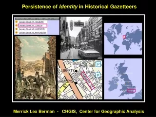
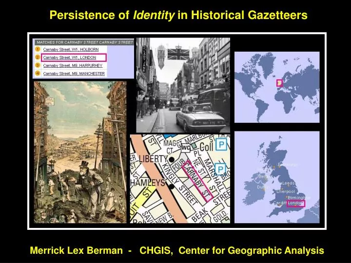
- historical gazetteer records as indirect geographic references - Carnaby Street, London 1966 Carnaby Street, London 1881
China Historical GISProject website:www.fas.harvard.edu/~chgis