Download
1 / 47
470 likes | 586 Views
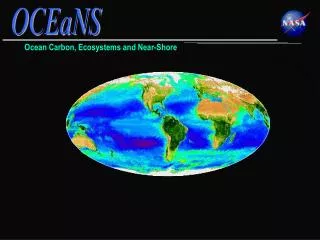
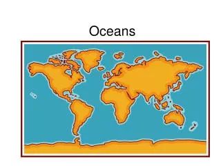
oceans. The Blue Planet. 14.1 The Vast World Ocean. Nearly 71 percent of Earth’s surface is covered by the global ocean. Oceanography is a science that draws on the methods and knowledge of geology, chemistry, physics, and biology to study all aspects of the world ocean.

E N D
The Blue Planet 14.1 The Vast World Ocean Nearly 71 percent of Earth’s surface is covered by the global ocean. Oceanography is a science that draws on the methods and knowledge of geology, chemistry, physics, and biology to study all aspects of the world ocean.
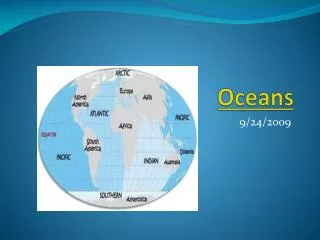
Geography of the Oceans 14.1 The Vast World Ocean The world ocean can be divided into four main ocean basins—the Pacific Ocean, the Atlantic Ocean, the Indian Ocean, and the Arctic Ocean. • The Pacific Ocean is the largest and has the greatest depth. • The Atlantic Ocean is about half the size of the Pacific and not quite as deep. • The Indian Ocean, largely a southern hemisphere body, is slightly smaller than the Atlantic. • The Arctic Ocean is about 7 percent of the size of the Pacific.
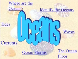
Mapping the Ocean Floor 14.1 The Vast World Ocean The topography of the ocean floor is as diverse as that of the continents. Bathymetry is the measurement of ocean depths and the charting of the shape or topography of the ocean floor. Today’s technology—particularly sonar, satellites, and submersibles—allows scientists to study the ocean floor in a more efficient and precise manner than ever before.
Mapping the Ocean Floor 14.1 The Vast World Ocean Sonar • Sonar is an acronym for sound navigation and ranging. It is also referred to as echo sounding. • Sonar works by transmitting sound waves toward the ocean bottom.
Mapping the Ocean Floor 14.1 The Vast World Ocean Satellites • Satellites are able to measure small differences by bouncing microwaves off the ocean surface. • Using this new technology, scientists have discovered that the ocean surface is not perfectly flat. • Differences in the height of the ocean surface are caused by ocean-floor features.
Mapping the Ocean Floor 14.1 The Vast World Ocean Submersibles • Submersibles are small underwater crafts used for deep-sea research. • Today, many submersibles are unmanned and operated remotely by computers. These remotely operated vehicles (ROVs) can remain underwater for long periods.
Salinity 15.1 The Composition of Seawater Sources of Sea Salt • Chemical weathering of rocks on the continents is one source of elements found in seawater. • The second major source of elements found in seawater is from Earth’s interior.
Salinity 15.1 The Composition of Seawater Processes Affecting Salinity • Processes that decrease salinity: - Precipitation - Sea ice melting - Icebergs melting - Runoff from land • Processes that increase salinity: - Evaporation - Formation of sea ice
Ocean Temperature Variation 15.1 The Composition of Seawater The ocean’s surface water temperature varies with the amount of solar radiation received, which is primarily a function of latitude. Temperature Variation with Depth • The thermocline is the layer of ocean water between about 300 meters and 1000 meters where there is a rapid change of temperature with depth. • Thethermoclineis a very important structure because it creates a barrier to marine life.
Ocean Density Variation 15.1The Composition of Seawater Density is defined as mass per unit volume. It can be thought of as a measure of how heavy something is for its size. Factors Affecting Seawater Density • Seawater density is influenced by two main factors: salinity and temperature.
Ocean Density Variation 15.1 The Composition of Seawater Density Variation with Depth • The pycnocline is the layer of ocean water between about 300 meters and 1000 meters where there is a rapid change of density with depth.
Ocean Layering 15.1 The Composition of Seawater Oceanographers generally recognize a three-layered structure in most parts of the open ocean: a shallow surface mixed zone, a transition zone, and a deep zone. Surface Zone • Shallow (300 to 450 meters) • Zone of mixing • Sun-warmed zone
Ocean Layering 15.1The Composition of Seawater Transition Zone • Between surface layer and deep zone • Thermocline and pycnocline Deep Zone • Sunlight never reaches this zone. • Temperatures are just a few degrees above freezing. • Constant high-density water
Surface Circulation 16.1 The Composition of Seawater Ocean current is the mass of ocean water that flows from one place to another. Surface Currents • Surface currents are movements of water that flow horizontally in the upper part of the ocean’s surface. • Surface currents develop from friction between the ocean and the wind that blows across its surface.
Surface Circulation 16.1 The Composition of Seawater Gyres • Gyres are huge circular-moving current systems that dominate the surfaces of the oceans. • TheCoriolis effect is the deflection of currents away from their original course as a result of Earth’s rotation.
Surface Circulation 16.1 The Composition of Seawater Ocean Currents and Climate • When currents from low-latitude regions move into higher latitudes, they transfer heat from warmer to cooler areas on Earth. • As cold water currents travel toward the equator, they help moderate the warm temperatures of adjacent land areas.
Surface Circulation 16.1 The Composition of Seawater Upwelling • Upwelling is the rise of cold water from deeper layers to replace warmer surface water. • Upwelling brings greater concentrations of dissolved nutrients, such as nitrates and phosphates, to the ocean surface.
Deep-Ocean Circulation 16.1 The Composition of Seawater Density Currents • Densitycurrents are vertical currents of ocean water that result from density differences among water masses. • An increase in seawater density can be caused by a decrease in temperature or an increase in salinity.
Deep-Ocean Circulation 16.1 The Composition of Seawater High Latitudes • Most water involved in deep-ocean currents begins in high latitudes at the surface. Evaporation • Density currents can also result from increased salinity of ocean water due to evaporation.
Deep-Ocean Circulation 16.1 The Composition of Seawater A Conveyor Belt • In a simplified model, ocean circulation is similar to a conveyor belt that travels from the Atlantic Ocean, through the Indian and Pacific Oceans, and back again.
Waves 16.2 Waves and Tides Wave Characteristics • Most ocean waves obtain their energy and motion from the wind. • The wave height is the vertical distance between the trough and crest. • The wavelength is the horizontal distance between two successive crests or two successive troughs.
Waves 16.2 Waves and Tides Wave Characteristics • The wave period is the time it takes one full wave—one wavelength—to pass a fixed position. • Fetch is the distance that the wind has traveled across open water. • The height, length, and period that are eventually achieved by a wave depend on three factors: (1) wind speed, (2) length of time the wind has blown, and (3) fetch.
Waves 16.2 Waves and Tides Wave Motion • Circular orbital motion allows energy to move forward through the water while the individual water particles that transmit the wave move around in a circle.
Waves 16.2 Waves and Tides Breaking Waves • Changes occur as a wave moves onto shore. • As the waves touch bottom, wave speed decreases. The decrease in wave speed results in a decrease in wavelength and an increase in wave height.
Tides 16.2 Waves and Tides Tides are daily changes in the elevation of the ocean surface. Ocean tides result from the gravitational attraction exerted upon Earth by the moon and, to a lesser extent, by the sun. Tide-Causing Forces • The force that produces tides is gravity.
Tides 16.2 Waves and Tides Tide Cycle • Tidal range is the difference in height between successive high and low tides. • Spring tides are tides that have the greatest tidal range due to the alignment of the Earth–moon–sun system. • Neap tides are tides that have the lowest tidal range, occurring near the times of the first-quarter and third-quarter phases of the moon.
Tides 16.2 Waves and Tides Tidal Patterns • Three main tidal patterns exist worldwide: diurnal tides, semidiurnal tides, and mixed tides.