Download
1 / 38
380 likes | 391 Views
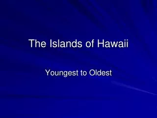
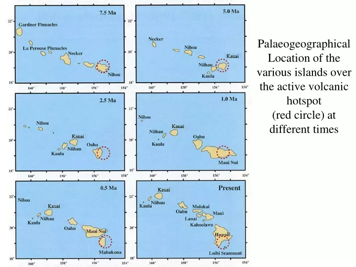
Palaeogeographical Location of the various islands over the active volcanic hotspot (red circle) at different times. Geology of island of O‘ahu. Composed of two different shield volcanoes Wai‘anae Volcano, > 4.0 to 2.8 Ma Shield-building and postshield alkalic cap stages

E N D
Palaeogeographical Location of the various islands over the active volcanic hotspot (red circle) at different times
Geology of island of O‘ahu • Composed of two different shield volcanoes • Wai‘anae Volcano, > 4.0 to 2.8 Ma • Shield-building and postshield alkalic cap stages • No rejuvenation stage! • Ko‘olau Volcano, 2.5 to 1.5 Ma (shield stage) • Shield-building and rejuvenation stages • No postshield alkalic cap! • Both volcanoes have also passed through erosion and coral reef growing stages • amphitheater-headed valleys • Abundant raised reefs • Both volcanoes have experienced giant submarine landslides
Ko‘olauVolcano Wai‘anaeVolcano
Wai‘anae Volcano, Shield Stage • Lualualei Member • >4.0 to 3.55 Ma • normal tholeiitic basalt, ~50% silica • Kamaile‘unu Member • 3.55 to ~3.1 Ma • transitional caldera-filling sequence • wider variety of minerals and rock types • some are very silica-rich, up to 66% • dying magma chamber?
Waianae Volcano, Postshield Stage • ~3.1 to 2.8 Ma • Mostly composed of hawaiite, an intermediate, alkalic igneous rock • Broken into two members • Pālehua (older) and Kolekole (younger) • separated by an erosional surface • Kolekole lavas are found on top of mudflow deposits • Kolekole is more mafic (has less silica) than Pālehua • may be related to the Wai‘anae Slump, a giant submarine landslide • removal of mass would lower pressure within the volcano, promoting decompression melting and higher degrees of partial melting
Ko‘olau Volcano, Shield Stage • Tholeiitic basalt, but unusually high Si, Al, Na, and Fe • old idea: chemical variations within the hot spot plume • New data from drilling shows that unusual chemistry disappears with depth and that deeper rocks are more like other shield-stage lavas in Hawaii • therefore, unusual chemistry is only in the top layer of Ko‘olau • may represent decline of melting in the volcano • was on its way toward a postshield stage that never happened
Nu‘uanu Landslide • Longest in the Hawaiian Islands, 230 km long • Traveled 80 km past axis of the Hawaiian Deep • in other words, moved uphill • Moved as a giant debris avalanche • a more catastrophic type of landslide • moved as isolated blocks • the Wai‘anae Slump, by comparison, moved as a single unit (similar to Kīlauea) • Age? • Paleomagnetism gives an ambiguous age, > 2.58 or 1.8 Ma, but well within the shield stage of Ko’olau
Ko’olau Volcano, Rejuvenation Stage • Called the Honolulu Volcanic Series • Very low silica rocks, ~36-42% SiO2 • very low degrees of partial melting • come directly from mantle, no magma chambers • Ages range from 800-600 Ka (poorly constrained) at the start to as young as 30 Ka • Sometimes erupt simultaneously along fissures • Koko Fissure • Sugarloaf-Roundtop-Tantalus • Both “wet” and “dry” eruptions, even in same fissure • Vents do not lie on shield’s rift zone, but rather their alignments are perpendicular to it
OAHU O’ahu has 178 miles of coast physically divided into the North Shore, South Shore, and Windward and Leeward coasts. The high-energy North Shore has the largest percentage of beaches (66%), while the reef-fronted Windward coast has the greatest number (55) and length of beaches (32 mi). The South Shore and Windward coasts, which are both of lower energy, have one-third of their shores dominated by sandy beaches, the remainder being rock and other types of shoreline. In total, O’ahu has 176 beaches covering 45% of the coastline.
Oahu, South Shore The south shore of Oahu begins at the high rocky headland of Makapu'u Point and extends to Barbers Point, 31 miles to the west. It consists of 56 miles of shoreline and 44 beaches that total 18.5 miles in length. Between sandy beaches the shoreline consists of rocky volcanic exposures (largely along the eastern portion), and heavily developed coastal communities (central and western portions). Along the Barber's Point region (to the west) the shoreline is rocky with sections of raised Pleistocene reefs. Most of the south shore is characterized by wide fringing reefs. These break up the energy of ocean swell, resulting in smaller waves at the shore and numerous surf breaks over the reefs. While the Waikiki beaches attract the limelight, there are other beaches along this shore that offer a wide, reef-controlled surf zone, without the backdrop of hotels and traffic.
Oahu, East Shore The Windward side of O'ahu is home to the island's longest and most exposed section of shoreline. It begins at Kahuku Point and trends to the southeast for 28 mi to Makapu'u Point. There are 65 mi of shoreline consisting of 55 beaches that occupy 50% of the shore, the remainder being dominated by basalt outcrops. All the beaches are exposed to the northeast trade winds and waves, however protection resulting from the dominance of extensive fringing and barrier reefs and bays allow usually only small waves at the shore. The result is a series of generally low-energy narrow beaches along the shore that are often backed and replaced by seawalls and in some cases are dominated by beachrock. Most beaches are fronted by wide fringing reefs, with various surf breaks commonly found over the outer reefs. Beach access along the coast is varying, from excellent along the Kamehameha and Kalanianole highways, to difficult east of Kuilima Bay and along sections occupied by beachfront houses, to restricted on the Kane'ohe and Bellows military bases.
Oahu, West Shore The west shore begins at the low Barbers Point and trends northwest for 22 miles to the prominent Kaena Point and its 750 foot high ridge. There are 28 mile of shoreline, alternating between sandy beaches, beachrock, raised Pleistocene reefs, and in the north the basalt of the Kaena Point region. The 26 beaches occupy 9 miles (33%) of the shore, the remainder is dominated by rock. The shore's westerly orientation permits north through west winter swells to reach the shore in the winter period as well as southerly summer swells. The result is year-round low to moderate surf punctuated by frequent periods of dangerous high surf. Trade winds typically prevail offshore. Due to the generally deeper inshore reefs, many of the surf breaks are close to shore.
Oahu, North Shore The North Shore of Oahu stretches from Kaena Point in the west 17 miles east to Kahuku Point. Fifty-one beaches occupy 11 miles or 66% of the shoreline. The remainder is dominated by basalt outcrops and raised Pleistocene reef, with beachrock outcrops along much of the sandy shore. The western half extends for 9 miles from Kaena Point to Haleiwa and faces due north. The eastern half faces northwest, finally curving south at Kahuku.
Waikiki, 2001 Preserve… Protect… Restore!