Download
1 / 28
280 likes | 284 Views
This project aims to enhance operational streamflow forecasts by incorporating snow data from remote sensing technology. It focuses on the Colorado River basin and the eastern Great Basin.

E N D
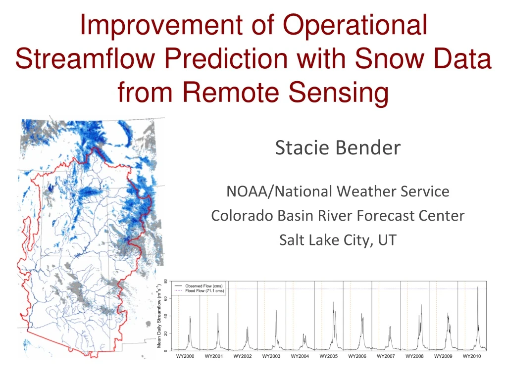
Improvement of Operational Streamflow Prediction with Snow Data from Remote Sensing Stacie Bender NOAA/National Weather Service Colorado Basin River Forecast Center Salt Lake City, UT
CBRFC • Full staff: 3 mgmt, 9 hydrologists, 1 admin, 1 IT • Vacancies: 1 mgmt, 1 hydro • Operational streamflow forecasts across the Colorado River basin and eastern Great Basin • Operational forecast types: • daily streamflow • seasonal peak flow • seasonal water supply volume CBRFC The R2O Gap Project Goals and Motivation MODSCAG & DRFS Datasets Uses of NASA/JPL Data at CBRFC Future Directions Emphasizing the Importance of Collaboration Summary • Colorado Basin River Forecast Center (CBRFC) www.cbrfc.noaa.gov National Weather Service River Forecast Centers
CBRFC CBRFC The R2O Gap Project Goals and Motivation MODSCAG & DRFS Datasets Uses of NASA/JPL Data at CBRFC Future Directions Emphasizing the Importance of Collaboration Summary • Hydrologic regimes: • snow-dominated to flash • flood hydrology • natural to regulated • 500+ streamflow forecast points • ~1200 modeling units (snow and soil moisture model run on each) • Colorado Basin River Forecast Center (CBRFC)
Importance of Snow Annual streamflow: primarily snowmelt-driven in CBRFC area of responsibility CBRFC The R2O Gap Project Goals and Motivation MODSCAG & DRFS Datasets Uses of NASA/JPL Data at CBRFC Future Directions Emphasizing the Importance of Collaboration Summary Annual hydrographs for the Weber R. headwater basin (northern Utah), water years 2000 to 2010 • Streamflow forecast users then, in turn, depend on snow: • NWS Weather Forecast Offices • US Bureau of Reclamation • water conservation districts • municipalities • recreational community • others
Operational CBRFC Models CBRFC The R2O Gap Project Goals and Motivation MODSCAG & DRFS Datasets Uses of NASA/JPL Data at CBRFC Future Directions Emphasizing the Importance of Collaboration Summary Operational Snow Model: SNOW17 Operational Soil Moisture Model: Sac-SMA
Operational CBRFC Models CBRFC The R2O Gap Project Goals and Motivation MODSCAG & DRFS Datasets Uses of NASA/JPL Data at CBRFC Future Directions Emphasizing the Importance of Collaboration Summary • Operational Snow Model: SNOW17 • minimum inputs: precip and temperature • runs quickly – benefit in operational environment • decades of NWS experience • calibrated to streamflow using the 1981-2010 • historical period (manual process at CBRFC) • temperature-index model • “melt factor” to represent the energy • balance throughout the year • forecasts snowmelt pretty well under near- • normal conditions of the calibration period • doesn’t do so hot when conditions deviate from • near-normal
Operational CBRFC Models CBRFC The R2O Gap Project Goals and Motivation MODSCAG & DRFS Datasets Uses of NASA/JPL Data at CBRFC Future Directions Emphasizing the Importance of Collaboration Summary • Operational Snow Model: SNOW17 • “melt factor” function for the year is a sine curve • two calibrated model parameters define the sine • curve (MFMAX for June 21, MFMIN for Dec 21) • as conditions deviate from the calibration- • defined melt factor function, forecasters may • manually apply a “melt factor correction”
CBRFC Modeling Units CBRFC’s operational models: lumped, not distributed Modeling units = elevation bands or zones each zone gets its own set of SNOW17 and Sac-SMA parameters via model calibration CBRFC The R2O Gap Project Goals and Motivation MODSCAG & DRFS Datasets Uses of NASA/JPL Data at CBRFC Future Directions Emphasizing the Importance of Collaboration Summary EXAMPLE: Animas River, Durango, CO (NWS ID = DRGC2) Durango
Snow and the CBRFC Operational Forecasting Process CBRFC The R2O Gap Project Goals and Motivation MODSCAG & DRFS Datasets Uses of NASA/JPL Data at CBRFC Future Directions Emphasizing the Importance of Collaboration Summary where snow improvements may potentially lead to streamflow prediction improvements • CBRFC Operational Hydrologic Forecasting Process: • Ultimately driven by CBRFC forecast users, who have decision deadlines and who need forecasts consistently and reliably Input Datasets: Must be reliably available in a timely manner CBRFC Hydrologic Model Computing = local Linux boxes (no supercomputer available) CBRFC Hydrologist / Forecaster (the “human component”) Given information about hydrologic conditions, the forecaster may modify the forecast that initially comes directly from the model (including manual adjustment of snow and/or soil model states) Official CBRFC Streamflow Forecasts CBRFC Forecast Users and Stakeholders: NWS Weather Forecast Offices, Bureau of Reclamation, Water Conservation Districts, Recreational River Community, others
Bridging the R2O Gap CBRFC The R2O Gap Project Goals and Motivation MODSCAG & DRFS Datasets Uses of NASA/JPL Data at CBRFC Future Directions Emphasizing the Importance of Collaboration Summary • Collaborative partnerships among operational and research-oriented groups • intended to accelerate the improvement of • snowmelt-driven streamflow predictions at CBRFC Productive research and academic communities ≠ automatic and easy transfer of research to operations (R20)
Bridging the R2O Gap • Some reasons for the notoriously difficult-to-bridge R20 gap: • Cultural - both sides need to understand their counterparts • researchers – usually have a specialty • NWS operational hydrologists - jacks/jills of many trades • Differences in hydrologic science and models used • Operational time constraints • forecasting agency needs input datasets available in NRT • forecast users need info quickly and reliably decisions • Scale of datasets (space and time) • field experiments vs. datasets with long period of record • dedicated experimental basins vs. results across a large area • IT Issues • computing power (no supercomputer for NWS hydro) • bandwidth CBRFC The R2O Gap Project Goals and Motivation MODSCAG & DRFS Datasets Uses of NASA/JPL Data at CBRFC Future Directions Emphasizing the Importance of Collaboration Summary
Project Goals and Motivations CBRFC The R2O Gap Project Goals and Motivation MODSCAG & DRFS Datasets Uses of NASA/JPL Data at CBRFC Future Directions Emphasizing the Importance of Collaboration Summary • Snowpack observations crucial to improving CBRFC streamflow prediction • Point networks like SNOTEL remain and will remain crucial to CBRFC operations. • Remote sensing (RS) data can fill in gaps between point stations, especially at high elevations, in mountainous terrain. Present and future: Past (pre-2013): • RS of SW CO snow cover from MODIS, with SNOTEL station locations (yellow) Point networks only • Expanding info available to the CBRFC forecaster: Remote sensing (MODIS, VIIRS) More robust set of snowpack observations Point networks + = Durango
Project Goals and Motivations CBRFC The R2O Gap Project Goals and Motivation MODSCAG & DRFS Datasets Uses of NASA/JPL Data at CBRFC Future Directions Emphasizing the Importance of Collaboration Summary • Establish a multi-year CBRFC/JPL collaboration: • Actually get across the R2O gap! • More efficiently integrate RS snow datasets into CBRFC forecasting • Improve overall understanding and communication between operational and research groups • Develop beneficial relationships specifically among snow and remote sensing science researchers and operational hydrologic forecasters
RS Snow Datasets CBRFC The R2O Gap Project Goals and Motivation MODSCAG & DRFS Datasets Uses of NASA/JPL Data at CBRFC Future Directions Emphasizing the Importance of Collaboration Summary • Exploit differences in spectral characteristics of snow in the VIS and NIR to derive snow cover and dust information • MODSCAG provides per-pixel (500 m) fractional snow cover (%) • MODDRFS provides per-pixel (500 m) radiative forcing by dust in snow (W m-2) • Both gridded datasets are available from JPL server in near-real time and over the MODIS period of record (2000-present) REFERENCES: Painter, T. H., K. Rittger, C. McKenzie, R. E. Davis, and J. Dozier, Retrieval of subpixel snow-covered area and grain size from MODIS reflectance data, Remote Sensing of Environment, 113, 868-879, doi:10.1016/j.rse.2009.01.001. Painter, T. H., A. C. Bryant, and S. M. Skiles, Radiative forcing of dust in mountain snow from MODIS surface reflectance data, Geophysical Research Letters, doi: 10.1029/2012GL052457.
Limitations of MODIS-derived Snow Data No direct SWE information Limited seasons of usefulness (fSCA values bounded by 0 to 100%) Impacts of vegetation Clouds, especially during stormy periods CBRFC The R2O Gap Project Goals and Motivation MODSCAG & DRFS Datasets Uses of NASA/JPL Data at CBRFC Future Directions Emphasizing the Importance of Collaboration Summary MODSCAG fSCA April 11, 2014 MODSCAG fSCA April 12, 2014 (clouds = gray)
Timeline of MODSCAG and DRFS Use at CBRFC • 2012: initial exploratory phase • CBRFC set up NRT processing of data from JPL • both groups began learning what they had gotten themselves into • 2013: • semi-quantitative use of MODSCAG fSCA at CBRFC • binary indicator of snow presence (or lack of) • add/subtract small amount of SWE • historical analysis of patterns in streamflow prediction errors and • MODDRFS dust-on-snow data (Annie Bryant PhD work) • 3 week visit to CBRFC during melt season by JPL’s Annie Bryant • 2014: • adding another version of MODSCAG fSCA to toolbox • automated alerts of model vs. MODSCAG “fSCA differences” • more extensive use of MODDRFS dust data in 2014 than 2013 CBRFC The R2O Gap Project Goals and Motivation MODSCAG & DRFS Datasets Uses of NASA/JPL Data at CBRFC Future Directions Emphasizing the Importance of Collaboration Summary
May 16, 2013 CBRFC forecast modifications due to MODSCAG (snow cover) CBRFC The R2O Gap Project Goals and Motivation MODSCAG & DRFS Datasets Uses of NASA/JPL Data at CBRFC Future Directions Emphasizing the Importance of Collaboration Summary Coal Creek, near Cedar City, UT, NWS ID: COAU1/USGS ID: 10242000 Past Future Past Future Before small SWE adjustment: Recent Obs Q Model Sim Q Official Fcst Q MODSCAG Snow Cover After small SWE addition: Observed Q (cfs)
MODDRFS and CBRFC Q Error Patterns CBRFC The R2O Gap Project Goals and Motivation MODSCAG & DRFS Datasets Uses of NASA/JPL Data at CBRFC Future Directions Emphasizing the Importance of Collaboration Summary Dust in the snowpack primarily impacts timing of snowmelt (and timing of subsequent snowmelt-driven streamflow peaks) Analysis shows that a dustier than average snowpack results in center of mass that is observed earlier than predicted (esp. SW CO) Very dusty years coincide with larger streamflow prediction errors REFERENCE: Bryant, A. C., T. H. Painter, J. S. Deems, and S. M. Bender (2013), Impact of dust radiative forcing in snow on accuracy of operational runoff prediction in the Upper Colorado River Basin, Geophys. Res. Lett., 40, 3945–3949, doi:10.1002/grl.50773.
Multiple MODSCAG fSCA Products CBRFC The R2O Gap Project Goals and Motivation MODSCAG & DRFS Datasets Uses of NASA/JPL Data at CBRFC Future Directions Emphasizing the Importance of Collaboration Summary • “Viewable” MODSCAG fSCA • what the MODIS instrument “sees” • if trees are snow-free but a snowpack exists under • them, MODIS will not observe that snowpack • more accurate in a remote sensing aspect • MODSCAG fSCA product used by CBRFC during 2013 melt • “Canopy-adjusted” MODSCAG fSCA – new for 2014 melt • In a nutshell: if MODSCAG algorithm detects snow and • green vegetation in the same pixel, the fSCA value is reset • to 100% • higher fSCA value than “viewable” MODSCAG fSCA • less accurate in a remote sensing sense but more • hydrologically useful • closer to SNOW17 values of snow cover extent
Multiple MODSCAG fSCA Products CBRFC The R2O Gap Project Goals and Motivation MODSCAG & DRFS Datasets Uses of NASA/JPL Data at CBRFC Future Directions Emphasizing the Importance of Collaboration Summary MODSCAG (a) “viewable” and (b) “canopy-adjusted” fSCA over southwestern Colorado, April 9, 2014, as viewed by CBRFC forecasters. (b) (a)
Daily “fSCA diff” List SNOW17 fSCA vs. MODIS fSCA -------------------------- Run date: 2014-04-11 Dates to review: 2014-04-07 to 2014-04-11 Type of MODIS obs fSCA used in these comparisons: Canopy-adjusted fSCA Pedstep of MODIS obs fSCA to use: SADR3ZZ Sim SWE (inches) range to scan: 0 to 3 MODIS FSCA QC Key (% grid cells that have non-fsca - might be cloud or edge of scan): A: 0% - best you can get - all pixels w/in elevation zone had valid fSCA values V: 75.001 to 100.00% - worst - most of pixels in the elevation zone were Basin Zone Date MODIS FSCA MODIS QC SNOW17 FSCA SNOW17 SWE -------- -------- ---------- ---------- -------- ------------ ---------- DRGC2H_F DRGC2HLF 2014-04-10 7.25 B 19.34 0.535 ** MODIS fSCA < 10% and SNOW17 SWE > 0 - need to take snow out? **DRGC2H_F DRGC2HLF 2014-04-09 2.29 B 22.60 0.704 ** MODIS fSCA < 10% and SNOW17 SWE > 0 - need to take snow out? **DRGC2H_F DRGC2HLF 2014-04-08 7.20 B 25.36 0.843 ** MODIS fSCA < 10% and SNOW17 SWE > 0 - need to take snow out? **DRGC2H_F DRGC2HLF 2014-04-07 7.50 B 26.26 0.890 ** MODIS fSCA < 10% and SNOW17 SWE > 0 - need to take snow out? ** CBRFC The R2O Gap Project Goals and Motivation MODSCAG & DRFS Datasets Uses of NASA/JPL Data at CBRFC Future Directions Emphasizing the Importance of Collaboration Summary
Sunday’s Storm CBRFC The R2O Gap Project Goals and Motivation MODSCAG & DRFS Datasets Uses of NASA/JPL Data at CBRFC Future Directions Emphasizing the Importance of Collaboration Summary April 11, 2014 April 14, 2014
NRT Dust Conditions CODOS, April 4: “… dust layer D4 may emerge in the coming week, absorbing solar radiation and accelerating the warming of the underlying snowcover at higher elevations, or enhancing snowmelt rates at lower elevations where the snowcover was already isothermal.” CBRFC The R2O Gap Project Goals and Motivation MODSCAG & DRFS Datasets Uses of NASA/JPL Data at CBRFC Future Directions Emphasizing the Importance of Collaboration Summary April 11, 2014 April 9, 2014 April 8, 2014 April 10, 2014 April 13, 2014 – storm/cloudy April 14, 2014 April 12, 2014
Near Real-time Dust Impacts on Q Forecasts Past Future CBRFC The R2O Gap Project Goals and Motivation MODSCAG & DRFS Datasets Uses of NASA/JPL Data at CBRFC Future Directions Emphasizing the Importance of Collaboration Summary Before “cranking up the melt factor” – sim Q is too low Recent Obs Q Model Sim Q Official Fcst Q Past Future After “cranking up the melt factor” – sim Q matches much better Recent Obs Q Model Sim Q Official Fcst Q
Near Real-time Dust Impacts on Q Forecasts CBRFC The R2O Gap Project Goals and Motivation MODSCAG & DRFS Datasets Uses of NASA/JPL Data at CBRFC Future Directions Emphasizing the Importance of Collaboration Summary Forecasts issued late in the week and over the weekend were better. Forecasts issued early to middle of last week were too low
Future Directions For the rest of 2014 and into 2015 (and beyond): Continue to use information provided by NASA/JPL snow-by-remote-sensing datasets in daily CBRFC streamflow forecasting manual SWE adjustments from MODSCAG fSCA info “melt factor” adjustments from MODDRFS dust info Further analysis of historical data: Expand analysis of MODDRFS and streamflow prediction errors Connect patterns in JPL data to patterns in snow model parameters Adjustments to MODIS NASA/JPL datasets – estimates for cloudy pixels, vegetation adjustments Look more closely at calibrated SNOW17 areal depletion curves and relationships to MODIS-derived snow data Work with collaborators to test snow model alternatives SWE reconstruction datasets CBRFC The R2O Gap Project Goals and Motivation MODSCAG & DRFS Datasets Uses of NASA/JPL Data at CBRFC Future Directions Emphasizing the Importance of Collaboration Summary
CBRFC/NASA/JPL Collaboration CBRFC The R2O Gap Project Goals and Motivation MODSCAG & DRFS Datasets Uses of NASA/JPL Data at CBRFC Future Directions Emphasizing the Importance of Collaboration Summary • Collaboration and open exchange of information • very beneficial to both CBRFC and NASA/JPL NASA/JPL gains awareness of: CBRFC operational forecasting and modeling process (including the “human component”) Operational requirements for data availability and timeliness CBRFC gains detailed knowledge of: NASA/JPL snow cover and dust-on-snow data and remote sensing in general How to overcome limitations in datasets (e.g., vegetation, clouds) People involved KEY to the project’s success.
Summary • CBRFC is using JPL’s snow remote sensing data! • MODSCAG fSCA for SWE adjustments • MODDRFS dust info for “melt factor corrections” • Potential future uses of snow remote sensing data: • Further analysis of historical MODIS datasets • Improvements in JPL remote sensing datasets (estimating conditions on cloud days, further vegetation corrections) • People make the collaborative R2O wheels go round. • Operational hydrologists • Remote sensing science experts Contact Info: CBRFC – Stacie Bender – stacie.bender@noaa.gov NASA/JPL – Tom Painter – thomas.painter@jpl.nasa.gov