Download
1 / 38
380 likes | 389 Views
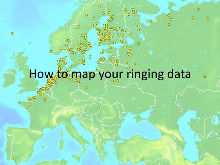
How to map your ringing data. Three different methods. Google Static Maps KML in Google Earth R package maprec. Three different methods. Google Static Maps KML in Google Earth R package maprec. Google Static Maps. Google Static Maps. http://maps.google.com/maps/api/staticmap?

E N D
Three different methods • Google Static Maps • KML in Google Earth • R package maprec
Three different methods • Google Static Maps • KML in Google Earth • R package maprec
Google Static Maps http://maps.google.com/maps/api/staticmap? size=640x640 &maptype=terrain (roadmap, satellite, hybrid) &markers=color:blue|57.283,-3.814 &sensor=false http://maps.google.com/maps/api/staticmap?size=640x640&maptype=terrain&markers=color:blue|57.283,-3.814&sensor=false
Google Static Maps http://maps.google.com/maps/api/staticmap? size=640x640 &maptype=terrain &markers=color:blue|51.483,0.183 &visible=58,-2|50,-4 &sensor=false http://maps.google.com/maps/api/staticmap?size=640x640&maptype=terrain&markers=color:blue|51.483,0.183&visible=58,-2|50,-4&sensor=false
Google Static Maps http://maps.google.com/maps/api/staticmap? size=640x640 &maptype=terrain &markers=color:blue|51.483,0.183 &markers=color:green|51.333,3.2 &visible=58,-2|50,-4 &sensor=false http://maps.google.com/maps/api/staticmap?size=640x640&maptype=terrain&markers=color:blue|51.483,0.183&markers=color:green|51.333,3.2&visible=58,-2|50,-4&sensor=false
Google Static Maps http://maps.google.com/maps/api/staticmap? size=640x640 &maptype=terrain &markers=color:blue|51.483,0.183 &markers=color:green|51.333,3.2 &path=color:red|weight:3|51.48,0.18|51.33,3.2 &visible=58,-2|50,-4 &sensor=false http://maps.google.com/maps/api/staticmap?size=640x640&maptype=terrain&markers=color:blue|51.483,0.183&markers=color:green|51.333,3.2&path=color:red|weight:3|51.48,0.18|51.33,3.2 &visible=58,-2|50,-4&sensor=false
Google Static Maps http://maps.google.com/maps/api/staticmap? size=640x640 &maptype=terrain &markers=color:blue|label:R|51.483,0.183 &markers=color:green|label:1|51.333,3.2 &path=color:0xff000055|weight:3|51.483,0.183|51.333,3.2 &markers=color:green|label:2|57.583,9.95 &path=color:0xff000055|weight:3|51.333,3.2|57.583,9.95 &markers=color:green|label:3|57.7,10.583 &path=color:0xff000055|weight:3|57.583,9.95|57.7,10.583 … &visible=58,-2|50,-4&sensor=false
Google Static Maps • Upsides • Relatively quick • Good for including in blogs etc • Downsides • Can only do a one or a few individuals • Not that customisable
Three different methods • Google Static Maps • KML in Google Earth • R package maprec
KML in Google Earth http://www.earthpoint.us/ExcelToKml.aspx
KML in Google Earth • Upsides • Quite easy to do • Interactive – eg zoom in, look at labels • Downsides • Quite a bit of typing (though can copy and paste) • Not so good for printing • Limit of 200 points (so fewer recoveries)
Three different methods • Google Static Maps • Google Maps/Google Earth • R package maprec
Using maprec in R • Upsides • Very flexible and customisable • Good for printing • You can save the code in a file and re-run it later, perhaps with another (or updated) dataset • Downsides • Need to install, set-up and learn (at least a bit ) R • Need a reasonably good computer and need to do some typing