Download
1 / 56
600 likes | 736 Views
Ocean Basins. Structure of the Oceans From Continental Shelf to Abyssal Depths. Measuring Depth. 85 BC Posidonius ~2km Hemp line and greased lead weight tension Fathoms (6 feet) Piano wire and cannonball w/ winch By 1895 only 7000 measurements to 2000m and 550 to >9000m

E N D
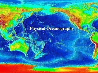
Ocean Basins Structure of the Oceans From Continental Shelf to Abyssal Depths
Measuring Depth • 85 BC Posidonius ~2km • Hemp line and greased lead weight • tension • Fathoms (6 feet) • Piano wire and cannonball w/ winch • By 1895 only 7000 measurements to 2000m and 550 to >9000m • Echo sounder (depth recorder) 1920s • Meteor- mid-Atlantic ridge • 1950s detailed mapping of ridges and trenches • Heezen and Tharp
Bathymetry • LADS (shallow water) • Laser airborne depth sounder • Fixed winged aircraft/ GPS • Operating depth of 0.5-70m • Gravity measurements • Changes in sea surface elevation • Seamounts +5m and ridges +10m • Trenches -25-30m • Satellite altimetry • Side-scan sonar
Bathymetry of the Sea Floor • Continental Margin- Passive and Active • Continental shelf (Flat- 10-1500km, 65km; 20-500m deep) • Continental shelf break • Continental slope (Steep) • Submarine canyons • Turbidity currents and turbidites • Continental rise • Ocean Floor • Ridges, Rises and Trenches
Slope Break Shelf Rise Mid- Atlantic ridge Computer Drawn Topographic Profiles
Ancient Turbidite Sequence Bouma Sequence Top- (E)Pelagic Seds (D)Parallel Laminated Sands (C)Rippled, wavy or convoluted laminae (B)Plane Parallel Laminae Bottom-(A)Massive Graded D C A
Bathymetry of the Sea Floor • Ocean Floor • Deep seafloor (4000-6000m cover 30% of Earth’s surface) • Abyssal Plain (Flat) • Pelagic sediments and turbidites • Abyssal hills and seamounts & Guyots • <1000m high; steep sided volcanoes • Found on 50% Atlantic and 80% Pacific seafloor • Some become atolls • Ridges, Rises and Trenches • 65,000km mountain range • Challenger Deep (Mariana Trench 11,020m)
Sediments • Continental margins and ocean basins receive continuous supply • Organic • plankton • Terrigenous (Land) • Rivers, beaches • Atmospheric • wind • Space • tektites (meteorites)
Continental Margin • Thick Sequence of sediments (1000’s m) • Passive margin • Gravels, sands, muds • Rates of deposition vary 8m/yr in estuaries • 5m/1000yr quiet bays • Shelf and slope 10-40cm/1000yrs • Carbonates • Salts • Potential for resources • Oil • Gas • Methane Hydrates
Sand and Gravel • 1.2 billion tons/yr • Reserves of 800 billion tons • US 450 billion tons • UK & Japan take 20% from seafloor • Other materials found within such as Fe, U, Pt, Au & Diamond • The Tin Belt of SE Asia • Carbonate sands
Oil and Gas account for 95% of material exploited from the sea 24.8% of oil and 20.7% gas in US came from offshore production (1997)
Gas Hydrates and other Gases • Geopressurized zones • Methane Hydrates, crystalline solids of gas and water abundant in arctic regions and marine sediments • 1 ft3 releases 160 ft3 gas • Offshore east coast area of potentially 1300 trillion ft3 gas • Reserves 4x1020 ft3
Atmosphere-Wind • Winds from deserts transfer terrigenous sediment 1000’s kms into ocean basin • Annual supply to oceans 100x106 metric tons • Sahara-Caribbean connection • Reefs • Soils
Sorting Well Poorly
Biogenous Sediment • Planktonic- Siliceous and Carbonate Oozes • Phytoplankton • Diatoms (silica) • Coccolithosphorids (carbonate) • Zooplankton • Radiolarians (silica) • Foraminefera (carbonate) • Lysocline (dissolution) • CCD (carbonate compensation depth) <20% preservation CO3 ~4500m • Atlantic (5000m) • Pacific (4200-4500m); Equatorial Pacific (5000m)
Diatoms Coccolithosphorids
Hydrogenous Sediment • Slow formation in water column • Chemically precipitated • Carbonates (ooids, calcareous muds) • Phosphorites (fertilizers) • Continental shelf and slope • Reserve ~ 50 billion tons • Nodules or crusts • Due to high nutrients-upwelling • Salts (Mediterranean) • Manganese nodules • Concentric layering • High in Fe, Cu also • 1-10cm diameter • Hydrothermal vents (smokers)-ores (sulfides)
Upwelling • When wind blow offshore, they push the warm surface waters away from the coastline • This creates a region of low pressure and may result in upwelling of deep water to replace surface water. • The deep waters contain dissolved nutrients which can support abundant life at the surface • Many fishing grounds exist in these areas, notably the west coast of N. & S.America and w coast of Africa