Download
1 / 11
110 likes | 290 Views
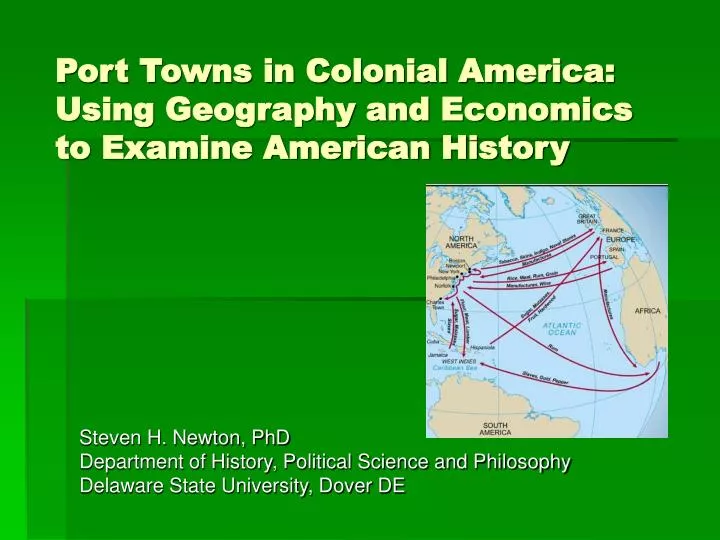
Port Towns in Colonial America: Using Geography and Economics to Examine American History. Steven H. Newton, PhD Department of History, Political Science and Philosophy Delaware State University, Dover DE. Remember the Triangular Trade?. From Africa to the Americas: Slaves

E N D
Port Towns in Colonial America: Using Geography and Economics to Examine American History Steven H. Newton, PhD Department of History, Political Science and Philosophy Delaware State University, Dover DE
Remember the Triangular Trade? • From Africa to the Americas: Slaves • From America to Europe: Agricultural Products • From Europe to Africa: Manufactured Goods • What’s Wrong with this Picture?
The Problem with Triangles (1) • North America was never a focal point of the Atlantic Slave Trade
The Problem with Triangles (2) • Over-simplification of trade patterns eliminates: • Reciprocal trade between North America and Europe • Intra-Colonial Trade within North America • Intra-Colonial Trade between North America and the West Indies • Development of Three Tiers of Port Towns within North America that affected economic and political history
North American Port Towns • Primary: • Philadelphia, New York, Boston, Charleston, Baltimore • Secondary: • Newport, Providence, Salem, New Haven, Norwich, New London, Norfolk • Tertiary: • Alexandria, Fredericksburg, Richmond, Georgetown, Savannah
Primary Port Towns • Size: • Primary Entry Port • Locus of Redistribution Network (Hinterland) • Shipbuilding Industry • Headquarters for Large-scale Merchant Houses • Insurance Industry • Imperial Presence • Fluid Population • High Levels of Political Activity
Primary Port Towns • Populations 1760 • Philadelphia—23,750 • New York—18,000 • Boston—15,631 • Charleston—8,000 • Baltimore—6,000 • Average Yearly Outbound Shipping Tonnage 1768-1772 • Philadelphia—42,790 tons • New York—26,278 tons • Boston—37,842 tons • Charleston—31,075 tons • Value of Exports/Imports to West Indies 1769 • Philadelphia • Exports—178,331 pounds • Imports—180,592 • Boston • Exports—123,394 pounds • Imports—155,387 • New York • Exports—66,325 pounds • Imports--97,420
Secondary Port Towns • Population range from 3,000-8,000 • Some direct export abroad but primarily handle intra-colonial trade • Exception: Smuggling • Far Less Diversified Economy • Only Minimal Imperial Presence • Politics is Overwhelmingly Local
Tertiary Port Towns • These are not really ports, but small towns in the population range of 400-2,000 that handle some incidental local and intra-colonial trade • These towns exist primarily in the South, and their development is hindered by the individual shipping arrangements of large planters, which cripples the development of towns
How Port Towns challenge us to re-interpret Colonial and Revolutionary History • Why political activism spread outward from major New England and Mid-Atlantic ports • How virtually invisible economic interactions tied the colonies together • Why the Southern colonies developed a completely divergent political economy before the Revolution