Download

1 / 49
490 likes | 603 Views
A Review of the NOAA IFEX Hurricane Field Experiments Conducted in 2007 John F. Gamache NOAA/AOML/Hurricane Research Division. Discussion Outline. IFEX 2007 Goals. HFP Activities Tropical Storm Erin (NHC-tasked reconnaisance; P-3) Hurricane Felix (EMC-tasked 3D Doppler winds; P-3)

E N D
A Review of the NOAA IFEX Hurricane Field Experiments Conducted in 2007 John F. Gamache NOAA/AOML/Hurricane Research Division
Discussion Outline IFEX 2007 • Goals HFP Activities • Tropical Storm Erin (NHC-tasked reconnaisance; P-3) • Hurricane Felix (EMC-tasked 3D Doppler winds; P-3) • Tropical Storm Ingrid (EMC-tasked 3D Doppler winds; P-3) • Tropical Depression 10 (NESDIS-42, HRD-43; P-3) • Hurricane Karen (EMC-tasked 3D Doppler winds; P-3) • Hurricane Noel undergoing ET (HRD-tasked P-3; Aerosonde flight)
IFEX 2007 • Goal 1 • Collect observations that span the TC lifecycle in a variety of environments: 3D Doppler Winds (Felix, Ingrid, TD 10, Karen) • Goal 2 • Develop and refine measurement technologies that provide improved real-time monitoring of TC intensity, structure, and environment (NHC): Aerosonde/P-3 (Noel); 3D Doppler Winds (Felix, Ingrid, TD 10, Karen) • Goal 3 • Improve our understanding of the physical processes important in intensity change for a TC at all stages of its lifecycle (HRD): Aerosonde/P-3 (Noel)
Tropical Storm Erin • 070815H1 (Reconnaissance) • 070816H1 (Reconnaissance--reached the storm after landfall)
Hurricane Felix4 Flights flown from St. Croix • 070901H1 (Tropical Storm to Minimal Hurricane--NOAA 42) • 070902I1 (Category 2 Hurricane--NOAA 43) • 070902H1 (Category 5 Hurricane--NOAA 42) • 070903H1 (Category 5 Hurricane--NOAA 43) • Observed rapid deepening with Doppler radar every 12 hours, beginning from strong TS to cat 5
070901H1 • Combination of flight patterns: • 1) Figure 4 pattern • 2) Square spiral--spiralling outward • 3) Flight centered on 0000 UTC 2 September 2007
070902I1 • Category 2 hurricane flight centered around 12 UTC on 2 September 2007 • Truncated “butterfly pattern” due to proximity to Venezuela and Islands north of it
070902H1 • Figure 4 pattern to be centered around 0 UTC 3 September 2007--truncated due to severe turbulence and protocols concerning G forces • Highest value of SFMR surface wind estimate on record
070903I1 • Figure 4 pattern, centered around 12 UTC 3 September 2007 • Hurricane Felix still category 5
Tropical Storm Ingrid6 Flights flown from Barbados • 070913I1 (3D Doppler Winds--NOAA 43) • 070914H1 (3D Doppler Winds--NOAA 42) • 070914I1 (3D Doppler Winds--NOAA 43) • 070915H1 (3D Doppler Winds--NOAA 42) • Approximately 30-hour hiatus • 070916I1 (3D Doppler Winds--NOAA 43) • 070917H1 (Ocean Winds--NOAA 42) • Observed highly sheared tropical storm every 12 hours with airborne Doppler radar
Tropical Depression 102 Flights flown from MacDill • 070921H1 (Ocean Winds/3D Doppler Winds) • 070921I1 (3D Doppler Winds/Landfall)
Hurricane Karen2 Flights flown from Barbados • 070926I1 (3D Doppler Winds--NOAA 43) • 070927H1 (3D Doppler Winds--NOAA 42) • Observed intensifying minimal hurricane encounter abrupt increase in vertical wind shear
Real-time Doppler data Issues • Further automation is needed to start analysis jobs--we will explore complete or near-complete automation during this off-season--improved during 2007 • Further automation in determining systematic error corrections for radar pointing angle is needed--accomplished in 2007 • Final format of data to be sent still must be agreed upon • Faster SATCOM communications will be needed to successfully send enough data to EMC--equipment purchased, very high speed more likely in 2009 • Further automation in transmitting files from P3 needed--much improved in 2007, will continue improvement • Better pre-season training needed for those operating HRD Doppler QC software aboard the P3--done first time in 2007, more in 2008, eventually including AOC/Non-HRD people
Highlights • First concerted effort to probe TC-core structure every 12 hours with SMFR and airborne Doppler • Coordinated NOAA P3 aircraft with aerosonde
IFEX 2008 • “Operations” • Off-season discussions with TPC, EMC, NESDIS, and AOC concerning tasking and flight tracks • Provide Doppler data to EMC after the flight for HWRF assimilation development • Supporting Synoptic Surveillance mission planning (HRD) and flying, as needed • Limited HRD resources to support a potentially substantial number of operational P3 flight hours • Flight testing of G-IV airborne Doppler and software to quality control the new data--will also be good practice for QC of updated Doppler radar on P3s in 2009 • “Research” • HRD: limited P-3 flight hours devoted to specialized HRD projects • Aerosonde, Genesis (weak systems), SALEX, Landfall/Inland decay • New DMT cloud physics probes
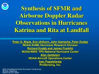
Aerosonde/Noel 071102I1--NOAA 43
Noel Aerosonde UAS mission coordinated with NOAA P-3 The Aerosonde UAS approached the center of Noel from the north (black), at around 400 m altitude. At the same time, the P-3 (red) was making a penetration from east to west at around 3500 m altitude. GPS dropwindsondes (blue) were deployed at the location where the aircraft met.
Take-off from Wallops Flight Facility (KWAL) 1600 UTC Aerosonde P-3 (3500 m) “Eye” loitering with vertical soundings (100-1500 m) KMCF Rendezvous with P-3 at storm center 0525 UTC