Download

1 / 11
110 likes | 226 Views
Basin Range Transition. Presented by Dan Dziekan and Richard Fletcher. 1. Day Field Guide Overview . 2. Stop One: Lava Butte Stop Two: Paulina Peak Stop Three: Hole in the Ground Stop Four: Green Mountain Lookout Stop Five: Crack in the Ground Stop Six: Winter Ridge

E N D
Basin Range Transition Presented by Dan Dziekan and Richard Fletcher
1 Day Field Guide Overview 2 Stop One: Lava Butte Stop Two: Paulina Peak Stop Three: Hole in the Ground Stop Four: Green Mountain Lookout Stop Five: Crack in the Ground Stop Six: Winter Ridge Stop Seven: Ana River Fault at Summer Lake 3 4 5 7 6
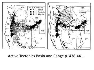
Brief Newberry Overview • Named after John Newberry • Caldera reaches 2,400 meters • Formed 80,000 years ago • Most recent eruption 1,300 years ago • Formed from Rhyolite to Basalt flows
Lava Butte • Northern most vent along Holocene fissure • Extends 30 km south to Newberry • Erupted 7,000 years ago • Began as a 2.4 km long fissure • Concentrated at the site of Lava Butte • 150 m high cinder cone • Eruptive products cover 23 km squared • Flows erupted from various vents
Paulina Peak • Located on southern side of Newberry Caldera • Provides Great view of many flows
Hole in the Ground • Maar formed when Newberry Lavas entered water saturated sediment of Fort Rock basin 50-100 thousand years ago. • Premature eruption
Green Mountain Lookout • Basalt Shield • Fed lava flow at Crack in the Ground • Around 740 thousand years ago • East lava field erupted from Lava Mountain Shield Volcano • Marked by a 1.6km long series of craters
Crack in the Ground • Northwest striking crack • Coincides with a Quaternary normal fault trace • Crack penetrates more than one lava flow • Suggests tectonic rather than volcanic • About 10 meters of vertical displacement
Winter Ridge • Stop located in the foot wall of Winter Ridge fault system • Viewpoint allows for multiple fault to be observed • Defines first extensional escarpment
Summer Lake • Pleistocene pluvial lake called Lake Chewaucan • Occupied basin formed between Winter Ridge and Abert Rim • Ana River and Winter Ridge faults cut shorelines