1 / 0

Florida Division of Emergency Management

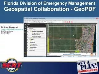
Florida Division of Emergency Management. EAS Alerts and Google Crisis Response Partnership. Richard Butgereit richard.butgereit@em.myflorida.com GIS Administrator 850-413-9907. http://bit.ly/MsEf1w. We are commonly leveraging alerts in GIS formats from – National Weather Service

kiley
Download Presentation

Florida Division of Emergency Management

An Image/Link below is provided (as is) to download presentation Download Policy: Content on the Website is provided to you AS IS for your information and personal use and may not be sold / licensed / shared on other websites without getting consent from its author. Content is provided to you AS IS for your information and personal use only. Download presentation by click this link. While downloading, if for some reason you are not able to download a presentation, the publisher may have deleted the file from their server. During download, if you can't get a presentation, the file might be deleted by the publisher.

E N D

Presentation Transcript


  1. Florida Division of Emergency Management EAS Alerts and Google Crisis Response Partnership Richard Butgereit richard.butgereit@em.myflorida.com GIS Administrator 850-413-9907
  2. http://bit.ly/MsEf1w
  3. We are commonly leveraging alerts in GIS formats from – National Weather Service http://www.nws.noaa.gov/gis (shapefile,kml) http://mesonet.agron.iastate.edu/GIS (shapefile) NOAA NOWCoast http://nowcoast.noaa.gov/help/mapservices.shtml (WMS) United States Geologic Survey http://earthquake.usgs.gov/earthquakes/catalogs (GeoRSS) http://nhss.cr.usgs.gov/data.shtml (REST) http://bit.ly/MsEf1w
  4. In our state, we are using ComlabsEMnet for emergency alert system origination, aggregation, and dissemination… State Watch Office and EOC County EOCs Florida Department of Law Enforcement Amber alerts, Silver alerts Nuclear Power Plants Broadcasters CAP compliant, but not bridged off of the EMnet http://bit.ly/MsEf1w
  5. We are working on getting these alerts off of EMnet and inserted into our enterprise GIS database for use with GATOR and other GIS tools… Other states using EMnet -- Alabama, Alaska, Delaware, District of Columbia, Florida, Georgia, Illinois, Indiana, Maryland, Massachusetts, Michigan, New Jersey, North Carolina, Pennsylvania, Puerto Rico, South Carolina, Tennessee, Virginia, and West Virginia. Have you built tools for CAP-to-Shape? http://bit.ly/MsEf1w
  6. Meanwhile, Google went ahead leveraging commonly available feeds… And went directly to Comlabs to negotiate directly using Florida alerts from Comlabs… And they offered something else – let’s partner on data beyond alerts… http://bit.ly/MsEf1w
  7. Google Maps Engine – formerly Google Earth Builder http://earthbuilder.google.com
  8. http://bit.ly/MsEf1w
More Related