Download
1 / 18
180 likes | 182 Views
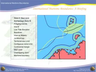
S-121 Maritime Limits and Boundaries Status report. IHO S-121 Standard on Maritime Limits and Boundaries. Louis M altais Serge Lévesque Canadian Hydrographic Service. 10 th HSSC meeting, May 14 – 17, 2018. What is the context.

E N D
S-121 Maritime Limits and Boundaries Status report IHO S-121 Standard on Maritime Limits and Boundaries Louis Maltais Serge Lévesque Canadian Hydrographic Service 10th HSSC meeting, May 14 – 17, 2018
What is the context Support the management, description and exchange of a State’s Maritime Sovereignty, Sovereign rights extents and associated juridical zones.
What is the mandate S-121 Maritime Limits and Boundaries (MLB) Project team was tasked to: • Defining a proposed data model • Create a product specification to support Law of the Sea Deposits. • Determine if S-100 needs to be extended to support Law of the Sea issues.
Who are the stakeholders States: • All levels of governments, HOs, Administration, Legal… International bodies: • DOALOS, CLCS, ITLOS, ISA, IMO, IHO… Industry: • Transportation, Security, Fisheries… Academia: • University, Research Centre…
What are S-121 objectives Flexible Support all user types and their MLBs usages. Correct Support precise and accurate MLBs description Authoritative Represent States view (structure and formats) Referenced Linkage to administrative source documents Version Data versioning to support and monitor changes Usable Simple, practical, expendable and implementable Focussed Support MLB legal and geospatial description Interoperable IHO S-100, and ISO standards compliant
When the standard should be used Based on two levels which follows the basic premise of ISO TC211 of the separation of the “carrier from the content”. Administer, manage and maintain MLBs Data Model Distribute and make MLB accessible Exchange formats S121PT1
Why do we need a new standard Different context • MLB legal context needs to be described • All MLB objects • Conceptual objects • Legal context • Parties & Roles • Rights, Restrictions & Responsibilities • Source description • Versioning New requirements • Such framework is not available in S-100 Findings
FINDINGS : Build on existing investment 19152 - LADM Administration
The FeatureObjects Locations Limits Zones
ConceptualLegal Sources S121PT1
The Information Objects S121PT1
Hypothetictypicaldeclaration Informative (ISO 19152 – LADM) Parties (S121_Party) Country A (Role: Owner) Sources (S121_Source) Legal Document X Geometries (S121_SpatialAttributeType) Point Rights (S121_Right) Sovereign Administrative (S121_BAUnit) T.S. Conceptual (S121_FeatureUnit) T.S. Area (+vertical domain) T.S. Outer Limit (For Zone or Space object only) Objects (S121_FeatureUnit) Basepoint Geospatial (IHO S-100 – Universal Model) S121PT1
The S121 Draft The proposed S-121 standard takes a practical step towards achieving the vision of S-100 as it was established: to expend the user base and better accommodate the requirements of our digital world. The proposed S-121 standard is designed to be a simple management (data model) and communication solution (exchange format) that is flexible enough to describe any type of MLBs for the broadest range of users.
DEVELOPMENT WORK ACHIEVEMENTS • Data model simple and yet flexible • Integrating S-100 and ISO 19152 • Leveraging S-100 object oriented capacities • Inline with IHO vision • Interoperable with land domain • Product specification • Human & Computer readable. • Exchange format meets the need for MLBs deposit to DOALOS • Layer compatible with AML to overlay S-101 charts • GML/KML to support due publicity • Suggesting an S-100 extension solution (ISO 19152) to support the description of Law of the Sea issues.
S-121 Progress • The S-121 project team has held several meetings • Two full group teleconference meetings • Face to face meeting New York December 2017 • Website www.s-121.com is established • Good progress made in producing version 1.0 of the product specification • Now submitted for wider review • Overview • Product Specification • Derivation of Classes • Draft Encoding • Feature Model Target date for a final specification: December 2018
Other activities • The team have also worked with ISOTC211, the LADM community and the OGC as part of their activities this year. • An OGC pilot has been launched to cover the following activities: • Development of fully interoperable GIS implementations of the emerging S-121 standard • Implement a legal dissemination format that is human readable, in accordance with the S-121 specification and which is suitable for deposit with UN DOALOS. • Development of a GML based exchange format to allow for the overlay of MLBs information over charts including its portrayal.
Recommended Actions • Recommended Actions for HSSC • Note status of standard and distribute to Member States for review. • Establish an MLB domain for S-121-specific content in the IHO register: feature objects and attributes