Download
1 / 58
590 likes | 786 Views
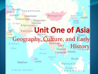
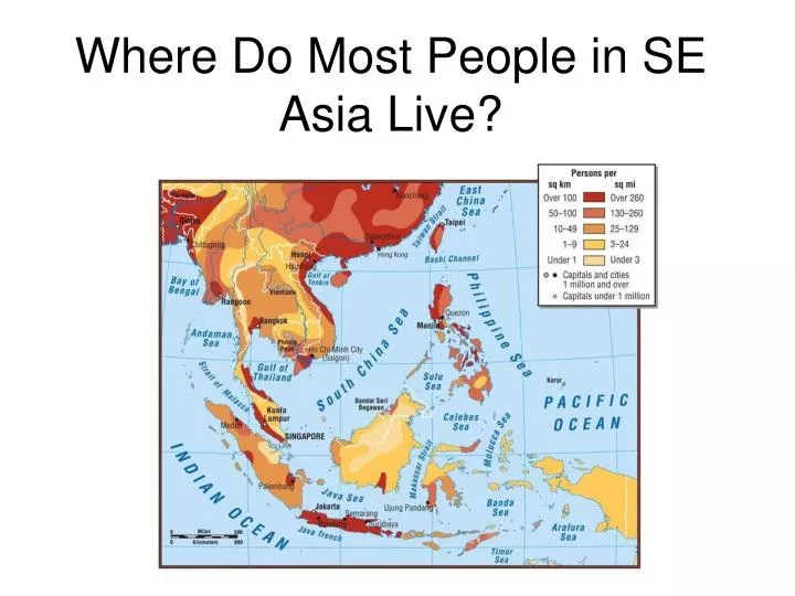
Where Do Most People in SE Asia Live?. GPS. SS7G11 The student will explain the impact of location, climate, physical characteristics, distribution of natural resources, and population distribution on Southern and Eastern Asia.

E N D
GPS • SS7G11 The student will explain the impact of location, climate, physical characteristics, distribution of natural resources, and population distribution on Southern and Eastern Asia. • a. Describe the impact climate and location has on population distribution in Southern and Eastern Asia. • b. Describe how the mountain, desert, and water features of Southern and Eastern Asia have affected the population in terms of where people live, the types of work they do, and how they travel.
E.Q. • How do location, climate, physical characteristics and distribution of natural resources impact the population distribution in SE Asia?
Think/Pair/Share • What do you think is important when choosing a place to live?
Vocabulary • Monsoon: seasonal wind • Semi-arid: partly dry • Typhoon: tropical hurricane • Border/Boundary: where 2 states or countries touch • Climate: the weather over a long period of time • Terrain: land • Nomad: a person who travels from place to place • Natural Resource: something found in the environment that people need and can use
Nearby oceans, mountains, deserts, latitude and wind patterns affect climate.How?
India: Many Types of Climate • North: mountains (snow and ice) • Middle: Deccan Plateau (hot and dry) • South: coastal (steamy and hot) • Border with Pakistan: hot, dry desert • Ganges Plain: humid (steamy) and tropical
India • Most people farm, so they live along the rivers and in fertile river valleys. • Some of India’s largest cities are along the Ganges River or the coast. • Fewer live in the Deccan Plateau.
India • Climate is shaped by seasonal winds. • Winter: monsoons blow from the northeast and bring hot, dry air from the desert. • Spring and summer: monsoons blow from southwest and bring heavy rains from the ocean. But…sometimes they bring too much. Summer monsoons bring much-needed rain.
India • People of India live their lives around the monsoons. • When the monsoons are mild, they are able to farm the rich river valley soil and use the rivers for transportation and trade.
China: Many Types of Climates • China is so large, it has nearly every kind of climate. • Mongolia, in the north, is semi-arid. • Deserts in the middle are harsh and dry. • High mountains in the south cut China off from India and block moisture from the Indian Ocean. • East and south: humid and tropical
China • Most of China’s 1.3 billion people live where the climate is milder, in the river valleys where the land is fertile.
Japan’s Climate • Island nation on far eastern edge of East Asia • Climate is affected by ocean currents • Japan Current (Kuroshio) comes from south – brings warm water to southern and eastern coasts (more farming) • Oyashio Current comes from north – coolsnorthern coast (more fishing)
Japan’s Climate • Monsoon rains • Tropical hurricanes called typhoons
North Korea’s Climate • North Korea shares a border with China • Short summers • Long cold winters • Mountainous • Not as heavily populated as South Korea Like the northeast corner of China
South Korea’s Climate • Fewer mountains • Milder climate due to warm winds from the ocean • Larger population than North Korea • Many live in the largest city, Seoul (that’s what makes it large, I guess…) • More farming than in North Korea
Vietnam’s Climate • Further to the southeast • Warmer and tropical • Warm climate and river plains create rich farmlands • 90% of the world’s rice is grown in Vietnam
CRCT Test Prep pages140-141 • The climate of India is affected by seasonal winds called • Hurricanes • Monsoons • Typhoons • Tornadoes B. Monsoons
CRCT Test Prep pages140-141 2. Where do most of the people of India live? • Southern coast • Center of the country • Northwest near Pakistan • Along the great rivers and fertile valleys D. Along the great rivers and fertile valleys
CRCT Test Prep pages140-141 3. What is the best way to describe the climate of China? • Hot and dry • Mild and temperate • Rainy and subtropical • Combination of all of these D. Combination of all of these
CRCT Test Prep pages140-141 4. Where do most Chinese live? • In Mongolia to the north • In the central hilly plateau region • Area of the country with milder climates • Around the Gobi and Taklimakan Deserts C. Area of the country with milder climates
CRCT Test Prep pages140-141 5. Which has a major effect on the climate of Japan? • Ocean currents • Monsoon rains from India • Winds coming off the desert • Cold air sweeping off large glaciers A. Ocean currents
CRCT Test Prep pages140-141 6. What is the best way to describe the climate and geography of North Korea? • Mountainous and cool • Large deserts, hot and dry • Mostly river delta and tropical • Mix of mountains and river valleys and mild temperatures A. Mountainous and cool
CRCT Test Prep pages140-141 7. Which type of climate makes Vietnam ideal for growing rice? • Warm and tropical • Dry and desert-like • Colder due to winds from glaciers • Bitter cold in winter, hot in summer A. Warm and tropical
India’s Physical Characteristics: Mountains • 3 mountain ranges separate India from the rest of Asia • Hindu Kush • Himalayas • Karakoram • For this reason, India is called a subcontinent http://www.youtube.com/watch?v=7gXixxYKM80
India’s Physical Characteristics: Mountains Good: Bad: Sometimes invaders used natural mountain passes to enter India and take over. • mountains have sometimes stoppedinvaders from the north who wanted India’s fertile river valleys.
Many of India’s large cities are in the fertile river valleys. Good: Bad: Rivers provide easiest way to dispose of waste human industrial animal Most cities have problems with overcrowding air and water pollution • Rivers provide • Transportation • trade routes • Water for irrigation & drinking • People move from rural areas to the cities to find work.
China’s Physical Characteristics:a Variety of Climates and Terrains • 2 deserts: • Gobi • Taklimakan • The few who live here are nomads and animal herders.
China’s Physical Characteristics:a Variety of Climates and Terrain • Some parts of northern and western China have moderate climates and farming is possible • Northeast (Huang He River Valley) is most populated • Beijing, China’s capital • industrialcenter of China
China’s Physical Characteristics:a Variety of Climates and Terrain • Southeast: Along Yangtze River Valley • mainly farming region • Shanghai, China’s largest port city, is here • Three Gorges Dam is here – world’s largesthydroelectric dam • Rapid industrialization has been good and bad for China: • People find more work in the cities • Cities become overcrowded as people move from rural areas
North Korea’s Physical Characteristics • Mountains make farming more difficult • Fast-flowing mountain rivers have been dammed to create hydroelectric power plants • North Korea makes a profit mining coal, iron, copper, and other minerals • Most people live on the western side • Mountains slope to the sea • farming is easier video
South Korea’s Physical Characteristics • Less mountainous • Much productive farmland • Larger population than DPRK • 25% of population lives in or near Seoul (capital) • markets • jobs • education • Milder climate than DPRK because of ocean winds
Japan’s Physical Characteristics • 80% is covered by mountains • Very little land is suitable for farming • Japan solves this problem by • Building terraces • Putting in irrigation channels • Using different fertilizers & farming techniques Japan still has to import food for its growing population
Japan’s Physical Characteristics:Volcanoes! Bad: Good: Hot springs around some volcanoes are used to heat water for people to use • Cause earthquakes – more than any other place in the world • But -the Japanese have adjusted to the threat of earthquakes, though many are destructive • Cause tsunamis
Japan’s Physical Characteristics • Japan does not have much arable land for farming. • Japanese depend on fishing for much of their food • Japan imports a lot of food from other countries • Japan has a highly industrialized economy, but nogas or oil resources • They must import fuel
Natural Resources: Arable Land • Rich farmland is one of the most valuable resources in SE Asia • All SE Asian countries depend on agriculture to feed their people • India & China have large areas of farmland • Still have trouble producing enough food to feed their rapidly growing populations
Natural Resources: Coal • India, China, North Korea, and South Korea have good supplies of coal. • Good: major fuel and energy source for countries’ economies • Bad: Major cause of air pollution • Air pollution is one of the greatest environmental hazards facing SE Asia
Natural Resources: Minerals • North & South Korea: lead, zinc • South Vietnam: phosphates, oil • Japan: almost no natural resources • Depends on industry and trade to supply its population with what they need
CRCT Test Prep pages142-144 • How have the mountain ranges in northern India affected the country’s development? • A life in the mountains is so hard that no one lives there. • The mountain ranges have prevented India from having any large cities. • The mountain ranges have often protected India from northern invaders. • Northern India has no large rivers because the mountains cut off the seasonal rains. C. The mountain ranges have often protected India from northern invaders.
CRCT Test Prep pages142-144 2. Why do so many of the people of India live in the Ganges River Valley? • The river provides fertile soil for farming. • The Ganges River is the only source of fresh water in India. • There are few other places in India where people can find work. • They live along the Ganges River to keep away from polluted industrial areas. A. The river provides fertile soil for farming.
CRCT Test Prep pages142-144 3. Why do most of the people of North Korea live in the western half of the country? • The rest of North Korea is made up of desert. • The area has more farmland and fewer mountains. • There are fewer cities and less pollution in the west. • There are no rivers in the mountains of North Korea. B. The area has more farmland and fewer mountains.
CRCT Test Prep pages142-144 4. Why do almost 25% of the people in South Korea live in and around Seoul? • The climate is subtropical and warm year-round. • The area around Seoul is protected from seasonal rains. • Most of the rest of the land in South Korea is not suited for farming. • The city provides markets, jobs, and education not available in rural areas. D. The city provides markets, jobs, and education not available in rural areas.
CRCT Test Prep pages142-144 5. How have the farmers of Japan been able to raise crops in land that is very mountainous? • They grow only those crops that do not need fertilizer. • Farmers are limited to crops that do not need irrigation. • They have built farming terraces along the mountain slopes. • They raise crops only in the small valleys found between the mountain ranges. C. They have built farming terraces along the mountain slopes.
CRCT Test Prep pages142-144 6. How do the Japanese feed their people with so little good farmland? • Many of the Japanese people starve each year. • The Japanese depend on fishing and imported food. • Tourists bring their own food when they visit from other countries. • The Japanese sell oil to earn money to buy food from other countries. B. The Japanese depend on fishing and imported food.
CRCT Test Prep pages142-144 7. Which is an example of a natural resource? • Factory • Deposit of coal • Irrigation canal • Hydroelectric dam B. Deposit of coal
Population Density in SE Asia • There are 5 physical criteria people consider when choosing (when they have a choice) where to live: • near coasts • near rivers and fresh water • temperate ("C") climates • flat terrain • fertile soil
Three Favorable Environments • Southeast Asia has approximately 546 million people. • The population tends to be clustered: 1. in the valleys and deltas of Southeast Asia’s major rivers 2. on volcanic soil on the islands of the Pacific rim's "ring of fire” 3. in regions that were once part of colonial plantations on the Malay peninsula
What to do: • Use the maps in this PowerPoint and the population maps to find out why people live where they do in SE Asia. • Pay attention to where the people seem to be clustered and figure out why.