Download
1 / 29
300 likes | 517 Views
Spatial Cloud Computing: How can the geospatial sciences use and help shape cloud computing?.

E N D
Spatial Cloud Computing: How can the geospatial sciences use and help shape cloud computing? Chaowei Yang , Michael Goodchild , Qunying Huang , Doug Nebert , Robert Raskin, Yan Xu , Myra Bambacus & Daniel Fay (2011) Spatial cloud computing: how can the geospatial sciences use and help shape cloud computing?, International Journal of Digital Earth, 4:4, 305-329, Presenters: Gayathri Gandhamuneni, James Wang Team URL: http://www-users.cs.umn.edu/~yumeng/
Topics • Motivation • Problem Statement & Illustration • Challenges • Major Contribution • Validation Methodology • Proposed Approach – SCC Scenarios • Key Concepts • Cloud Computing, Spatial Cloud Computing • Assumptions • Preserve and Revise
Motivation • Constant changes • Better recorded through space – time dimensional data • Exabytes of data accumulated • Increasing at rate of PB • Analysis of information changing • Understand, protect & improve living environment • Ex: Predict events like earthquakes, tsunamis… • Need of computing infrastructure that can • Reduce IT work • Real time applications support • Deal with access spikes, Support massive users
Problem Statement • Input: Geospatial Sciences (GS) Information • Output: Computing Infrastructure suitablefor GS • Objective: Research on challenges in geospatial sciences and use of Spatial Cloud Computing for solutions. • Constraints: SpatioTemporal Principles & Geospatial env.
Challenges • Information Technology challenges for Geospatial sciences • Data Intensity • Support of massive data storage, processing &system expansion • Computing Intensity • Algorithms and models based on Earth phenomena are complex • Complexity grasp of spatiotemporal principles • Concurrent Access Intensity • Lot of end users trying to access concurrently • Spatiotemporal intensity • Geospatial datasets space – time dimensions • Spatiotemporal – Static/Dynamic
Major Contributions • Categorization - Challenges of Geospatial Sciences in 21st century • Relation of Cloud Computing & Geospatial Sciences • Cloud Computing usage and how spatiotemporal principles enhance it • Examples to show how spatial cloud computing can solve 4 intensity problems • Most Significant • Looks ahead to see possible solutions for intensity problems
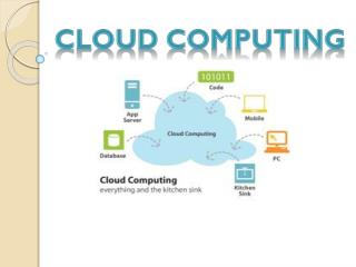
Cloud Computing • Advanced Distributed Computing • Provides ‘computing as a service’ • ‘Pay-as-you-go’ model • Model: • Convenient, on-demand network access • Access to shared pool of computing resources • Ex: networks, servers, storage, applications and services • Resources can be provisioned and released fast • Minimal management effort • Service provider interaction
Characteristics of Cloud Computing • Cloud Computing difference to other distributed approaches • On-Demand Self Service • As needed automatically • Broad Network Access • Different types of network terminals • Resource Pooling • Consolidation of diff. types of Computing resources • Rapid Elasticity • Rapidly & elastically provisioning, allocating & releasing resources • Measured Service • Supports pay-as-you-go approach
Advantages of Cloud Computing • Rapid Deployment • Dependability/Redundancy • Flexibility/Scalability • Levelled Playing Field • Security • Identity Management & Access Control What are the advantages of Cloud Computing?
Services for Cloud Computing • Cloud Computing is provided through 4 services • Infrastructure as a Service (IaaS) • Platform as a Service (PaaS) • Software as a Service (SaaS) • Data as a Service (DaaS) Geospatial Sciences
Uses of Cloud Services • Earth Observation (EO) Data Access: • Fast, secure access & utilization of EO data • Storage & Processing needs - DaaS • Parameter Extraction: • Complex geospatial processes – Reformatting & Reprojecting • PaaS can be used • Knowledge & Decision Support: • Used by domain experts, managers or public • SaaS provides good support • Social Impact & Feedback: • SaaS such as Facebook & email can be best utilized
Spatial Cloud Computing (SC2) • Cloud Computing Paradigm • Driven by geospatial sciences • Optimized by Spatiotemporal principles • Geospatial Science Problems • Intensive Spatiotemporal constraints & Principles • Best if spatiotemporal rules for geospatial domains used
GeoSpatialPrinciples • Physical phenomena are • Continuous • Heterogeneous in space, time, and space-time scales; • Semi-independent across localized geographic domains and can be divided and conquered • Geospatial science and application problems include the spatiotemporal locations of • Data Storage • Computing/processing resources • Physical phenomena • Users • Spatiotemporal phenomena that are closer are more related (Tobler’ first law of geography)
Validation Methodology • Four scenarios given for 4 intensity problems in order to validate their work • Case study to show that SCC might solve the four problems of geospatial sciences
SCC: Spatiotemporal Intensity Scenario • Real-time traffic network - Metropolitan area like DC, • Static Routing – 90k nodes, 200k links, 90k*90k origin & destination requests • Several Optimized routes for one OD request pair – 1 GB • Dynamic Real – Time Routing • Routing condition – Changes for each min. and each link & node • Daily - Volume increases by about (2460) 1TB • Weekly– (24607) 10TB • Yearly - (2460365)- 1PB
Assumptions • Methods and principles of geospatial sciences that can drive and shape computing technology would remain unchanged • Unreliable assumption • Both the development in technology & geospatial sciences itself might cause changes to occur • Validation done with examples of particular scenario • Can cloud computing be used always • Overhead cost of cloud computing might be > Cost without cloud computing
Application Areas • Spatiotemporal principle mining & extracting • Important digital earth & complex geospatial science and applications • Supporting the SCC characteristics • Security • Citizen and Social Science
Present & Future • Present:
Present & Future • Present: • Google Maps: Encouraged Web developers • Other Companies: GISCloud.com, SpatialStream.com • Web based solutions for GIS functions • Spatial Analysis & Data management • ESRI’s ArcGIS Online – ArcGIS.com • Future: • Security – Personal & Sensitive data • Boundaries • Mostly on internet • Wary about location of data and services • Source: http://www.linkedin.com/groups?gid=1839124
Exercises/Questions to Check • What are the problems faced by geospatial data? • What are geospatial principles? • What does system of systems solution include? • What is Cloud Computing? • Different services of Cloud Computing? • How is Cloud Computing different from others? • What is Spatial Cloud Computing? • What scenarios Spatial Cloud Computing can be used in context of geospatial sciences?
Preserve & Revise • Revise • Whole paper - Recent advancements in cloud computing • More practical examples of SC2 scenarios • Security issues faced and any possible solutions • Preserve • Different types of intensities • Cloud Computing & SC2 key concepts • Relationship between both
References • [1] Chaowei Yang , Michael Goodchild , Qunying Huang , Doug Nebert , Robert Raskin, Yan Xu , Myra Bambacus & Daniel Fay (2011) Spatial cloud computing: how can the geospatial sciences use and help shape cloud computing?, International Journal of Digital Earth, 4:4, 305-329, doi: 10.1080/17538947.2011.587547 • [2] Buyya, R., Pandey, S., and Vecchiola, S., 2009. Cloudbus toolkit for market-oriented cloud computing. Cloud Computing, Lecture Notes in Computer Science, 5931 (2009), 24_44. doi: 10.1007/978-3-642-10665-1_4. • [3] Olson, A.J., 2010. Data as a service: Are we in the clouds? Journal of Map & Geography Libraries, 6 (1), 76_78. • [4] Mell, P. and Grance, T., 2009. The NIST definition of cloud computing Ver. 15. [online]. NIST.gov. Available from: http://csrc.nist.gov/groups/SNS/cloud-computing/ • [5] Yang, C., et al., 2011a. WebGIS performance issues and solutions. In: S. Li, S. Dragicevic, and B. Veenendaal, eds. Advances in web-based GIS, mapping services and applications. London: Taylor & Francis Group, ISBN 978-0-415-80483-7. • [6] Yang C., et al., 2011b. Using spatial principles to optimize distributed computing for enabling physical science discoveries. Proceedings of National Academy of Sciences, 106 (14), 5498_5503. doi: 10.1073/pnas.0909315108.