Download
1 / 16
160 likes | 172 Views
CE 394 K GIS in water resources GEOCHEMISTRY of AUSTIN STREAMS Qianru Zeng Fall 2002. My objective of this project was to have experience in applying GIS technology in stream studies.

E N D
CE 394 K GIS in water resources GEOCHEMISTRY of AUSTIN STREAMS Qianru Zeng Fall 2002
My objective of this project was to have experience in applying GIS technology in stream studies. • This project was based on the MS research of Lance Christian from the department of Geological Sciences of University of Texas at Austin.
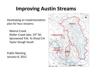
In order to judge the degree of urbanization within a watershed. • I choose The waller creek watershed in the downtown area for geochemistry analysis. • I will use G.I.S to analysis the geochemical attribute by join data table of Alkalinity, major and trace element concentrations, oxygen, and strontium, PH, conductivity parameters.
Nitrate concentrations in public water supplies have risen above acceptable levels in many areas of the world, largely as a result of overuse of fertilizer and contamination by human and animal waste
Work in progress! • The following work should use the strontium-lead isotope system to create potentiometric surface map and link the geochemistry data with hydrological models.