Download
1 / 23
340 likes | 737 Views
Unit 3.3: California Geology. Geologic Processes:. Tectonic processes inside Earth: Subduction: Pacific plate sinks below North American plate, creates large pools of magma that crystallize – forms batholiths Sierra Nevada Mountain Range

E N D
Geologic Processes: • Tectonic processes inside Earth: • Subduction: • Pacific plate sinks below North American plate, creates large pools of magma that crystallize – forms batholiths • Sierra Nevada Mountain Range • Juan de Fuca plate subducts below North American plate, produces volcanoes of Cascade Range • Mount Shasta, Mount Lassen • Accretion: • Slabs of crust “push” into North American plate, form Coast Range
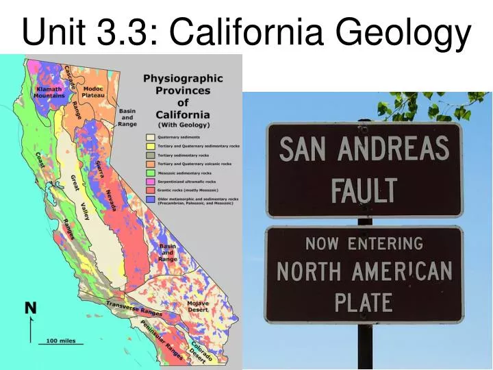
Faulting: • Uplift and movement of plates creates other ranges: • Basin and Range mountains east of Sierras • Transform boundary where Pacific plate moves north relative to N. American plate: • San Andreas Fault • Faulting causes other regions to “drop”, creates basins • Central Valley • Basin regions of Basin and Range Mtns. • Includes Death Valley
Surface processes: • Water erosion shapes mountains, river valleys. • Sierras: rivers cut V-shaped valleys along steep sides • Central Valley: along valley floors, rivers spread out and slow down, leaving alluvial deposits • alluvium: clay, silt, sand, gravel left by flowing streams in a river valley or delta, typically producing fertile soil • Glacial ice carved mountainous regions • Creates vast U-shaped valleys as glaciers move • Yosemite Valley
Deposition of sediment: • Desert landforms produced by water, wind • Few plants to prevent erosion • Ex: dunes and playas of the Mojave Desert • playa: flat, dry lake bed where mineral salts form by evaporation • Central Valley was once an inland sea • As Sierra and Coast ranges uplifted, left Central Valley as a basin, filled with sediment that washed down from nearby mtns. • Leaves fertile soil for agriculture
California’s Natural Hazards • Earthquake Hazards: • Tsunamis: undersea earthquakes or landslides can trigger enormous waves. • Dozens locally in the past 200 years • And from afar: Alaska, Japan • Tsunami Warning System alerts coastal communities • Seismic shaking: caused by earthquakes • Decreases as you move away from epicenter
Liquefaction: water-soaked soil becomes thick liquid during an earthquake • Can cause building collapse • Landslides: loose rock/soil on slopes slides away during an earthquake • Steeper slopes = greater chance of landslide • More likely after forest fire or droughts because plants that hold soil in place are damaged
Volcano Hazards include volcanic ash, lava flows, and volcanic gases • Cascade Range volcanoes: • Black Butte, Medicine Lake are currently dormant • Shasta erupted in 1700’s and Lassen in early 1900’s so are considered active • “Volcanic fields”: area covered by volcanic rocks • Dormant, but could become active again • Long Valley caldera releases CO2 gas that, in high concentrations, is deadly to plants and animals
Storm Hazards: • Mudflows occur when a mass of very wet soil/rock flows quickly downhill, moves faster as it picks up loose debris • More common when rainfall is higher than normal • Southern California is more susceptible because it’s a drier region, but can also occur in Northern California • Mudflows also occur in regions affected by wildfire • Wildfires eliminate the plants that hold the ground in place
California’s Resources: • Sand/gravel used in construction is mined from alluvial deposits • Crushed stone used in cement is limestone from shells, areas once covered by Pacific Ocean • Granite, sandstone, shale used for decorative building stone • Mineral Resources: includes minerals, rocks, sediments, and products made from them • Industrial Minerals: sand, gravel, crushed stone, building stone
Metallic Minerals: gold, silver, iron • Gold/silver occur in quartz veins in igneous and metamorphic rocks created when mountains form. • Placer deposits form when gold/silver settle out of moving water because they are more dense. • Gold mined in Sierra Nevada, Klamath, Mojave regions • Silver mined in Sierra Nevada • Iron found in Mojave Desert: magma heats rock and water producing iron-rich solutions. As solution cools, iron is deposited in rock fractures.
Nonmetallic Minerals: evaporites, clay • Borates form when boron-rich water flows into desert lakes and evaporates. • Used for making fiberglass, detergents, glass, ceramics, and insulation • Gypsum forms when salt-water or sulfur-rich water (in caves and hot springs) evaporates • Used in wallboard, plaster, and cement • Clay minerals form from weathered feldspar (a mineral) • Used in ceramics and for making bricks • Gemstones: mineral-rich solutions crystallize deep underground. • Tourmaline, garnet, agate, and jade
Major Energy Resources: • Oil: ~15% of US oil produced in California • Oil is formed when organic matter (dead plants/animals) sediments, undergoes physical/chemical changes. • Shale is “source rock” for this oil. • Oil can migrate into nearby porous rocks called “reservoir rocks”
Natural Gas: forms along with oil • Mostly methane, but other gases as well • Less dense than oil, so rises to top of reservoir • Geothermal: abundant in volcanic areas • A geothermal field occurs where magma close to surface heats ground water (becomes steam). • Engineers drill wells that “capture” steam that powers turbines to generate electricity
California’s Geomorphic Provinces: • Eleven Regions: • Klamath Mountains • Cascade Range • Modoc Plateau • Sierra Nevada • Coast Range • Great Valley • Basin and Range • Transverse Range • Peninsular Ranges • Mojave Desert • Colorado Desert
Klamath Mountains: • Considered a northern extension of Sierra Nevada • Peaks reach 8,000 feet • Gold-bearing gravels • Cascade Range: • Chain of volcanic cones extending from Washington through Northern California. • Mt. Shasta: 14,162 feet • Pit River flows through it to Sacramento River
Modoc Plateau: • Volcanic table land built of lava flows and tuff beds • Cut by many N-S faults • Bounded by Cascade Range and Basin and Range • Sierra Nevada: • Tilted fault block 400 miles long • Crest culminates in Mt. Whitney – 14,495 feet • Gold-bearing veins in Mother Lode • Northern boundary disappears under Cascades
Coast Range: • NW-trending peaks ~4000 feet • Northern range separated from Southern range by San Francisco • Runs sub-parallel to San Andreas Fault • Great Valley: • Alluvial plain 50 miles wide and 400 miles long – fertile soil • North is Sacramento Valley • South is San Joaquin Valley • Oil fields in south • Sutter Buttes: isolated volcano
Basin and Range: • Westernmost part of Great Basin • Many lakes and playas • Includes Death Valley and Owens Valley • Transverse Range: • “transverse” = cut across • E-W trending steep range, instead of N-S • Includes San Miguel, Santa Rosa, and Santa Cruz Islands • Intense N-S compression causes peaks to rise • Petroleum-rich rocks = oil…
Peninsular Ranges: • NW-trending valleys • Topography is similar to Coast Ranges • Geology is similar to Sierra Nevada – granitic rock • Includes Catalina islands off coast
Mojave Desert: • Isolated mountain ranges separated by desert plains • Fault trends define region: NW-SE and E-W trend that parallels Transverse Range • Bounded by San Andreas and Garlock Faults • Colorado Desert: • Low-lying barren desert basin – 245 feet below sea level • Dominated by Salton Sea • Depressed block between San Andreas Fault and Mojave Desert