Download
1 / 10
100 likes | 166 Views
Data Integration and Location-Aware Access to Resources. Isabel F. Cruz. ADVIS Lab Department of Computer Science University of Illinois at Chicago. Workshop on GeoSpatial and GeoTemporal Informatics NSF, January 8-9, 2009. Data Integration Example. Global RDF schema. Local XML schema.

E N D
Data Integration and Location-Aware Access to Resources Isabel F. Cruz ADVIS LabDepartment of Computer ScienceUniversity of Illinois at Chicago Workshop on GeoSpatial and GeoTemporal Informatics NSF, January 8-9, 2009
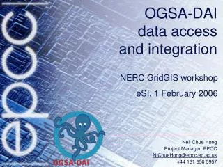
Data Integration Example Global RDF schema Local XML schema Local XML schema Local XML schema HealthInsurance XML instances Laboratory Testing XML instances Hospital XML instances Mapping Mapping Mapping Local RDF schema Local RDF schema Local RDF schema Mapping Mapping Mapping
Data Integration Example Global RDF schema Local RDF schema Local RDF schema Local XML schema Local XML schema Local XML schema HealthInsurance XML instances Laboratory Testing XML instances Hospital XML instances Global Query Rewritten Query Rewritten Query Rewritten Query Local RDF schema Query Query Query 3
Schemas are known Single-layer No uncertainty Same granularity (space and time) Conditions do not change over time (nor do the conclusions) RBAC model Single strategy No uncertainty Simple inferencing (space and time) Conditions do not change over time (nor do the policies) What Is Solved or Being Solved? Data Integration Location Awareness
Examples of “What is missing”(Data Integration) • Considering several “layers” at a time • Population, traffic, weather, flooding, land use/cover, …, e.g., to understand the spread of wild fires • Approximate concept matching • E.g., residential vs. urban • Time/space heterogeneity • E.g., demographic information available from different years or aggregated in different areas • Fuzzy spatial boundaries • E.g., no exact separation between prairie and desert
Examples of “What Changes”(Data Integration) • Many (very large) data sets • Legacy data • Any format, no clear data model • Data mining could play a part in understanding what to match/ how to match • Ontology (concept) matching • What gets matched (multi-layer vs. multiple single layer strategies) • Metrics • Query processing techniques • Query rewriting (multi-layer vs. multiple single layer strategies) • Uncertainty must be taken into account
“What Has Been Overlooked”(was “What Has Failed”) • Real and compelling applications • Real domain experts and users • Mixing up tools and solutions • Google Maps • Geospatial One-Stop • GIS standards • …
What is Next? High Risk and Needed Topics Data Integration Location Awareness • Query processing in the presence of uncertainty • Extended metrics • Multi-layer strategies • Time and space considerations (analysis, prediction) • Inferencing expressiveness and language efficiency • Extended constraints • Different organizations • Time and space considerations (resources, policies)