Download
1 / 29
300 likes | 537 Views
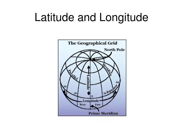
Latitude and Longitude. Lines of Latitude and Longitude:. Imaginary lines running around the globe that create an imaginary grid over Earth’s surface.

E N D
Lines of Latitude and Longitude: • Imaginary lines running around the globe that create an imaginary grid over Earth’s surface.
Latitude lines run east/west but they measure north or south of the equator (0°) splitting the earth into the Northern Hemisphere and Southern Hemisphere.
Lines of latitude are numbered from 0° at the equator to 90° N.L. at the North Pole. Lines of latitude are numbered from 0° at the equator to 90° S.L. at the South Pole. Latitude North Pole South Pole 90 80 [ 70 60 50 40 30 20 ] 10 10 20 30 40 50 60 70 80 90
The equator is at 0° latitude. It is neither north nor south. It is at the center between north and south. 40° N is the 40° line of latitude north of the equator. 40° S is the 40° line of latitude south of the equator. LatitudeThe North Pole is at 90° NThe South Pole is at 90° S
Longitude lines run north/south but they measure east and west of the Prime Meridian (0°) splitting the earth into the Eastern Hemisphere and Western Hemisphere.
60° W is the 60° line of longitude west of the Prime Meridian. The Prime Meridian is located at 0°. It is neither east or west 60° E is the 60° line of longitude east of the Prime Meridian. LongitudeLines of longitude begin at the Prime Meridian. W E
Lines of longitude are numbered east from the Prime Meridian to the 180° line and west from the Prime Meridian to the 180° line. Longitude 180° N North Pole W E West Longitude East Longitude PRIME MERIDIAN S
Western Hemisphere Eastern Hemisphere Places located east of the Prime Meridian have an east longitude (E) address. Places located west of the Prime Meridian have a west longitude (W) address. Prime MeridianThe Prime Meridian (0°) and the 180° line split the earth into the Western Hemisphere and Eastern Hemisphere.Prime Meridian
By combining latitude and longitude, any location can be pinpointed
East West, North South on the Earth N • Let each of the four quarters then be designated by North or South and East or West. W E S
East West, North South on the Earth • The N tells us we’re north of the Equator. The S tells us we’re south of the Equator. • The E tells us that we’re east of the Prime Meridian. The W tells us that we’re west of the Prime Meridian. (N, W) (N, E) (S, W) (S, E)
East West, North South on the Earth • That means all points in North America will have a North latitude and a West longitude because it is North of the Equator and West of the Prime Meridian. (N, W) Prime Meridian
ApplicationN W E S North America is in the Northern Hemisphere because it is north of the Equator. North America is in the Western Hemisphere because it is west of the Prime Meridian.
So Where is (0,0)? • The origin point (0,0) is where the equator intersects the prime meridian. • (0,0) is off the western coast of Africa in the Atlantic Ocean.
LONGITUDE AND TIME • The world rotates (spins) 360° in 24 hours. 360° / 24 hours = 15° per hour • The world has 24 time zones, each l5° apart. THERE IS A 1 HOUR TIME DIFFERENCE FOR EVERY 15° OF LONGITUDE
Greenwich, England is the logical starting point for time zones • The world rotates west to east (counterclockwise), time zones to the east are ahead of the those time zones to the west
ANOTHER CHEESY SAYING • EAST INCREASE Time is forward to all places to the east • WEST LESS Time is backward to all places to the west
East Increase – West Less(1 hr per l5°) If it 9 p.m. at Position D, what time is it at position C? Position B? If it is 1 p.m. at Position X, at which location is the time 5 p.m.
Earth rotates west to east Solar time is based on the position of the sunNIGHT IS FALLING ON EARTH Look at the East Coast of the United States. The lights are already lit. California the sun is still visible.
Saguenay Sept-Iles Thunder Bay Toronto St.John Ottawa It’s still daylight in California Québec Montréal Those light are Boston, New York, Philadelphia and Washington. Detroit Dallas Puerto Rico Houston Miami Mexico City Havana Port-au-Prince
NIGHT IS FALLING ON EARTH. Look at Paris and Barcelona, the lights are already lit, meanwhile in London, Lisbon and Madrid the sun is still visible. Looking south, we can see the islands in the middle of the ocean. We have a perfect view of the British Islands, Iceland and Canada.
Iceland England Atlantic Ocean France Spain Italy AFRICA
Locating Points on a Map • Yesterday we talked about this imaginary grid of the world. We discussed lines of latitude and longitude. We also delved into the four hemispheres and time zones. However, still don’t know how to locate points on any TYPE of map using our grid.
How Do I Use These Lines?! • Latitude comes first. Longitude comes second. (N/S comes first. E/W second. • Always put a degree sign ° after the number.