Download
1 / 11
110 likes | 221 Views
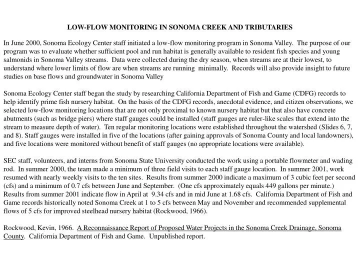
LOW-FLOW MONITORING IN SONOMA CREEK AND TRIBUTARIES

E N D
LOW-FLOW MONITORING IN SONOMA CREEK AND TRIBUTARIES In June 2000, Sonoma Ecology Center staff initiated a low-flow monitoring program in Sonoma Valley. The purpose of our program was to evaluate whether sufficient pool and run habitat is generally available to resident fish species and young salmonids in Sonoma Valley streams. Data were collected during the dry season, when streams are at their lowest, to understand where lower limits of flow are when streams are running minimally. Records will also provide insight to future studies on base flows and groundwater in Sonoma Valley Sonoma Ecology Center staff began the study by researching California Department of Fish and Game (CDFG) records to help identify prime fish nursery habitat. On the basis of the CDFG records, anecdotal evidence, and citizen observations, we selected low-flow monitoring locations that are not only proximal to known nursery habitat but that also have concrete abutments (such as bridge piers) where staff gauges could be installed (staff gauges are ruler-like scales that extend into the stream to measure depth of water). Ten regular monitoring locations were established throughout the watershed (Slides 6, 7, and 8). Staff gauges were installed in five of the locations (after gaining approvals of Sonoma County and local landowners), and five locations were monitored without benefit of staff gauges (no appropriate locations were available). SEC staff, volunteers, and interns from Sonoma State University conducted the work using a portable flowmeter and wading rod. In summer 2000, the team made a minimum of three field visits to each staff gauge location. In summer 2001, work resumed with nearly weekly visits to the ten sites. Results from summer 2000 indicate a maximum of 3 cubic feet per second (cfs) and a minimum of 0.7 cfs between June and September. (One cfs approximately equals 449 gallons per minute.) Results from summer 2001 indicate flow in April at 9.34 cfs and in mid June at 1.68 cfs. California Department of Fish and Game records historically noted Sonoma Creek at 1 to 5 cfs between May and November and recommended supplemental flows of 5 cfs for improved steelhead nursery habitat (Rockwood, 1966). Rockwood, Kevin, 1966. A Reconnaissance Report of Proposed Water Projects in the Sonoma Creek Drainage, Sonoma County. California Department of Fish and Game. Unpublished report.
Results of Low-Flow Monitoring:Sonoma Creek and Tributaries HY 2000 to 2002
Low-Flow Monitoringis gauging stream flow in Sonoma Creek and tributaries during the dry season.
Objective 1 To evaluate whether sufficient pool and run habitat is available to resident fish species from April 1 until rains resume each year.
To gain insight on base flow Objective 2 • The flow of water entering stream channels from groundwater sources
What is the location name? Where is the monitoring location? Is there a staff plate? Why was the site selected? Sonoma Creek A(SON-1) Sugarloaf Bridge, Adobe Canyon Road Nursery area for rainbow trout/steelhead Sonoma Creek B Highway 12 immediately north of Adobe Cyn Rd, Kenwood yes Habitat transition zone Sonoma Creek C(SON-3) 986 Warm Springs Road Habitat transition zone Sonoma Creek D(SHB) Sonoma Developmental Center yes Roach zone Sonoma Creek E Larson Park below dam, Boyes Hot Springs Sucker zone
Location? Where? Gauge? Why? Calabazas Creek(CAL-2) Dunbar Road crossing yes Good nursery for rainbow trout/steelhead Stuart Creek (STU-2) Highway 12 at Glen Ellen Curve yes Good nursery in upper section Carriger Creek (CAR-1) Arizona Crossing on Marilyn Goode property 3 miles of good nursery
Location? Where? Gauge? Why? Rodgers Creek Via Colombard crossing in Temelec development yes Good nursery for rainbow trout/steelhead Nathanson Creek(NAT-2) Nathanson Creek Nature Preserve Minor nursery potential
Equipment and Methods • Digital flowmeter attached to an English top-setting wading rod. • U.S. Geological Survey and Clean Water Team protocols for stream flow gauging and instantaneous measurements
2001 Low Flow Max/Min Sonoma B: 1.05/0 Sonoma A: 0.47/0.06 Sonoma C: 7.63/0.13 Calabazas: 0.03/0 Sonoma D: 9.34/0.28 Stuart: 0.03/0 Carriger: 0.44/0.04 Sonoma D: 12.37/0.27 Nathanson: 0.28/0 Rodgers: 0.14/0 N to San Pablo Bay
Data Summary Appendix C, Sonoma Creek Watershed Limiting Factors Analysis, Sonoma Valley Knowledge Base http://knowledge.sonomacreek.net/node/37 Thank you!