Download
1 / 30
300 likes | 309 Views
National Flood Management Conference 2019 FLOOD RISK MANAGEMENT IN IRELAND. Mark Adamson Office of Public Works 27 th February, 2019. ‘CFRAM’ STUDIES. ‘CFRAM’ PROGRAMME Outcome of National Flood Policy Review, 2004 Compatible with FD Requirements, 2007 Flood Maps FRMPs Pilot Studies:

E N D
National Flood ManagementConference 2019FLOOD RISK MANAGEMENTIN IRELAND Mark Adamson Office of Public Works 27th February, 2019
‘CFRAM’ STUDIES • ‘CFRAM’ PROGRAMME • Outcome of National Flood Policy Review, 2004 • Compatible with FD Requirements, 2007 • Flood Maps • FRMPs • Pilot Studies: • Lee, Dodder, Fingal – East Meath: 2005-2011 • National Programme: 2011-2018 • Focused on 300 Communities (‘AFAs’)
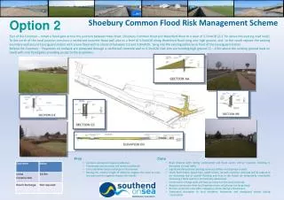
SCOPE OF WORK • Survey & Data Collection • Appx. 6,500kms River Channel • Hydrology • Incl. Use of FSU • Hydraulic Modelling • 1D-2D Dynamically Linked Models • Flood Mapping • Extent, Depth, Velocity, ‘Risk-to-People’, Flood Zone & Various Risk Maps
‘CFRAM’ STUDIES • FLOOD MAPS (‘CFRAM’ PROGRAMME) • Range of Flood Maps Produced • Extent, Depth, Velocity, ‘Risk-to-Life’, Flood Zone & Various Risk Maps • Up to 8 Flood Event Probabilities • Future Scenario Mapping • 2 Representative Climate Futures • MRFS: +500mm MSL, +20% Qp • HEFS: +1000mm MSL, +30% Qp
FLOOD MAPS • Detailed Mapping for 300 Communities • Incl. 90 Coastal Communities • Communities with Appx. 3m People (Appx. 2/3rds Population) • Less Detailed Mapping for Appx. 2,500 km Other River • Inform: • Sustainable Planning • Emergency Response Planning • Community Resilience
‘CFRAM’ STUDIES • FRMPs – COMMUNITY-LEVEL MEASURES
‘CFRAM’ STUDIES • FRMPs – COMMUNITY-LEVEL MEASURES • Screening & Option Development • Options Developed to ‘Line-&-Level’ & Costed • Appraisal • Multi-Criteria Analysis (MCA) • Cost-Benefit Analysis (CBA) • SEA / AA Environmental Assessment • Adaptability to Climate Change • Public Consultation: Over 450 PCDs
‘CFRAM’ STUDIES • FRMPs – COMMUNITY-LEVEL MEASURES • Overall FRS Programme (Protection) • 43 Schemes Completed • 35 Schemes in Construction, Design, Planning • 118 Further Schemes Proposed in FRMPs • Protection for Appx. 33,000 Properties: • Appx. 95% Properties at Risk in AFAs • Appx. 80% Properties at Risk Nationally
‘CFRAM’ STUDIES • FRMPs – NATIONWIDE MEASURES • Prevention: • Sustainable Planning & Devt. Management • Sustainable Planning Critical for Sustainable FRM • Guidelines: The Planning System and Flood Risk Management (OPW/DECLG, 2009) • Supported by OPW Advice & Flood Mapping
‘CFRAM’ STUDIES • FRMPs – NATIONWIDE MEASURES • Prevention: • Sustainable Planning & Devt. Management • Sustainable Planning Critical for Sustainable FRM • Guidelines: The Planning System and Flood Risk Management (OPW/DECLG, 2009) • Supported by OPW Advice & Flood Mapping • Consider Local Changes and Site-Specific FRAs
‘CFRAM’ STUDIES • FRMPs – NATIONWIDE MEASURES • Prevention: • Sustainable Planning & Devt. Management • Sustainable Urban Drainage Systems • Voluntary Home Relocation Scheme • Climate Change Adaptation Planning • Natural Water Retention Measures (ICM)
‘CFRAM’ STUDIES • FRMPs – NATIONWIDE MEASURES • Preparedness & Resilience: • Flood Forecasting & Warning • National Flood Forecasting Centre • Emergency Response Planning • Promotion of Individual / Community Resilience • Individual Property Protection • Flood Event Data Collection
FLOOD RISK MANAGEMENT PLANS • Finalised 3rd May 2018 • Published: www.floodinfo.ie
FUTURE WORK • CAPITAL FLOOD RELIEF PRPOGRAMME • Government Commitment • Budgets Allocation of Circa €1bn (NDP 2018-2027) • Annual Budget to Increase to €100m/yr • 10 Schemes in Construction, 25 in Design / Planning • Almost 120 Additional Schemes – FRMPs • Prioritisation – Appx. 50 ‘Tranche 1’ Schemes • Progressing to Project-Level Assessment • Generally Local Authority Lead; Part X
FUTURE WORK • ADAPTATION TO CLIMATE CHANGE • The ‘CFRAM’ Programme • Future Scenario Flood Mapping / Risk Assessment • Assessment of Adaptability of Options • National Future Scenario Flood Mapping • Adaptation in Flood Relief Schemes • Adaptability of Past Flood Relief Schemes • Apply Managed Adaptive Approach • Scheme Adaptation Plans • Update Sectoral Adaptation Plan: Sept. 2019
FUTURE WORK • NATURAL WATER RETENTION MEASURES • Emerging Approach often Promoted • Detailed Assessment at Project Scale • Concerns / Issues to Address: • Difficulty in Quantifying Projected Benefits • Effectiveness in Large Events • Intensive Land Owner Engagement • Benefits to Other Sectors: Integrated Catchment Mgt. • Research / Pilot Projects
FUTURE WORK • PREVENTION AND PREPAREDNESS • Flood Forecasting and Warning • National Flood Forecasting Service in Development • Emergency Response & Community Resilience • Review of Emergency Response Plans, Informed by CFRAM Maps • Enhance Community Resilience • Property Resilience • Home Relocation Scheme • Pilot ‘IPP’ Schemes
FUTURE WORK • SECOND CYCLE OF FLOODS DIRECTIVE • Review of PFRA, Flood Maps, FRMPs • Review, Not a ‘Re-Do’ • Opportunities for Refinement / Improvement • Consideration of Climate Change • Scope (AFAs): 1st Cycle • Relatively Low Threshold of Risk (Recent Floods) • Comprehensive Coverage of Communities • 2nd Cycle • No Need to Replicate CFRAM Programme • Focus on Understanding Risk in Rural Areas
FUTURE WORK • SECOND CYCLE OF FLOODS DIRECTIVE • Sources: • New National, Indicative Fluvial Mapping • Review Extreme Coastal Levels • Groundwater / Turlough Mapping • Risk from Urban-Storm Water Systems / Artifical Water-Bearing Infrastructure • Impacts: • Understanding Rural Risk • Critical Infrastructure • Impacts of Climate Change
FUTURE WORK • SECOND CYCLE OF FLOODS DIRECTIVE • PFRA: • Historic Flood Information (Floods 2012-Date) • Predictive Assessment of Risk (Incl. CFRAM Data) • Local and Expert Knowledge • Flood Maps: • Ongoing Changes (Infrastructure, Floods) • Need to Reflect Changes in Timely Manner • Flood Risk Management Plans: • Review of Progress on 1st Cycle FRMP Measures • Additional / Amended Measures
SUMMARY • CFRAM – EVOLUNTIONARY STEP FORWARD: • Assessment Covering 3m People (2/3rds National Population) • 2nd Cycle: Review, Refine and Improve • PROTECTION: • >150 Schemes In-Hand / Proposed in FRMPs • Broadening Approach: NWRM / ICM • Ensuring Adaptability to Future Climate • PREVENTION & PREPAREDNESS: • Sustainable Planning & Development • National Flood Forecasting Centre • Community Resilience
National Flood ManagementConference 2019FLOOD RISK MANAGEMENTIN IRELAND Mark Adamson Office of Public Works 27th February, 2019