Download
1 / 35
350 likes | 564 Views
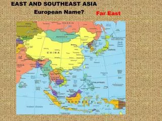
South, Southeast, and East Asia. Physical Geography. Land and Sea. The peoples Republic of China makes up about 80% of the land area of East Asia Also, China has the world’s largest population at 1.3 billion people. China’s neighbor Mongolia occupies about 13% of East Asia’s land.

E N D
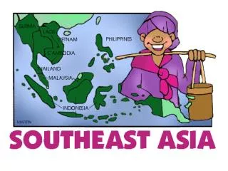
South, Southeast, and East Asia Physical Geography
Land and Sea • The peoples Republic of China makes up about 80% of the land area of East Asia • Also, China has the world’s largest population at 1.3 billion people. • China’s neighbor Mongolia occupies about 13% of East Asia’s land. • Mongolia however is one of the most sparsely populated countries in the world.
Land and Sea • The other countries in East Asia are Japan, Taiwan, North Korea, and South Korea. • Hong Kong and Macau are bustling ports that are now part of China.
Peninsulas, Islands, and Seas • There are many peninsulas and islands in this region. • These landforms divide the oceans into smaller bodies of water including the Yellow Sea, Sea of Japan, and the East China Sea. • The Korean peninsula is the most notable peninsula in this region.
Peninsulas, Islands, and Seas • Four large mountainous islands and thousands of smaller ones form the archipelago, or island chain, of Japan. • Honshu is the largest island of Japan with Hokkaido to the north and Kyushu and Shikoku to the south.
Islands • There are many archipelagoes in Asia such as: • Japan • Philippines • Indonesia Honshu is the largest island of Japan with Hokkaido to the north and Kyushu and Shikoku to the south.
Other Islands • Some other islands in Asia are: A. Hainan B. Taiwan C. Singapore D. Hong Kong
Ring of Fire • Part of Asia is on The Ring of Fire, an area around the Pacific Ocean where many tectonic plates meet. This area is at a greater risk for having earthquakes and active volcanoes.
Ring of Fire • Tsunamis are very prevalent in this region. • In 1993 more than 200 Japanese civilians lost their lives in a deadly tsunami. • The worst tsunami ever recorded happened in Japan in 2011. Almost 16,000 people lost their lives and an estimated 235 billion dollars worth of damages.
Mountains • Mountains are important in Asia because they influence: • Population patterns • Movement of people and goods • Climate
Mountains • The most important mountain range in Asia is the Himalaya Mountains. • The Himalayas separate India from China. • The Himalayas block clouds that are formed by monsoons from entering Western China. • The Himalayas isolate Tibet and make transportation difficult.
Mountains • Some other mountains in East Asia are: • Atlay Mountains • The Tian Shan Mountains • Mount Fuji in Japan • Qin Ling Mountains
Mountains • Mount Fuji is the tallest mountain in Japan at 12,388 ft. The mountain is located on the island of Honshu and it is considered sacred by Shintos.
Plateaus and Uplands • Most of Western China is on a plateau called the Plateau of Tibet. This plateau is over 15000 feet above sea level. Farther north is the Mongolian Plateau. • The Korean Peninsula and the Japanese Islands are mountainous.
Rivers and Bodies of Water • Many rivers in Asia start in the Himalaya Mountains. • Rivers erode away the mountains and carry sediment (little bits of dirt) down to the flat plains at the base of the mountains. • The sediment makes the soil by the rivers fertile and a good place to farm.
The Rivers of China • China has three major rivers that begin in the Himalayas and flow into the East China Sea or Yellow Sea. Chinese Name River Huang He Yellow River Yangtze River Chang Jiang West River Xi Jiang
The Rivers of China • The Yangtze and Yellow Rivers flow through an area that is flat in elevation called the North China Plain. This area has intensive farming and the two rivers are connected by The Grand Canal. The type of dirt found here is called loess. It is a rich soil that is yellow in color and normally deposited by the wind.
The Rivers of China • The Amur River starts in the Great Khingan Mountains in Northern China and empties into the Sea of Japan. This river is also a border between China and Russia.
Rivers in Southeast Asia • The longest river in Southeast Asia is the Mekong River. This river starts in the Himalayas and flows through China, Laos, Cambodia, and Vietnam before emptying into the South China Sea.
The Gobi Desert • The largest desert in this area is the Gobi Desert. • The Gobi Desert is formed by orographic precipitation. South Asia gets rain from the monsoons but the Himalaya Mountains block the rain from entering Western China. Most of Western China and Mongolia are in a rain shadow.
Islands • A group of islands is called an archipelago. There are many archipelagoes in Asia such as: • Japan • Philippines • Indonesia
Natural Resources • Numerous natural resources inhabit East Asia, such as: • Iron ore, tin, tungsten, and gold • Oil, coal, and graphite • Many farm as well asforest (grow cedar, hemlock, and oak).
Climate and Vegetation • Part of Asia is in the low latitudes otherwise known as the tropics. These areas have tropical wet or tropical wet and dry climates. What countries are in this area? A. Myanmar, Thailand, Laos, Cambodia, Vietnam B. Indonesia, Malaysia, Singapore, Philippines
Climate and Vegetation • Tropical wet climate zones always have tropical rainforests. One problem in many parts of Asia is deforestation.
Climate and Vegetation • China, Korea, Japan, and Taiwan are in the middle latitudes. Many of these areas have a humid sub-tropical or humid continental climate. Most of Western China is a desert.
Climate and Vegetation • Most of Northern Japan has a humid continental climate zone. This climate zone can also be found in Maine and New Hampshire. The winters are cold and it snows. http://www.youtube.com/watch?v=590_mhAuZhc
Climate and Vegetation • Part of Mongolia is a desert and part of it is covered by steppe. • In addition as in South Asia, monsoon winds bring season weather patterns which creates their seasons. • The monsoon winds brings rain that provides 80% of the annual rain which is important for farming.