Download
1 / 15
150 likes | 267 Views
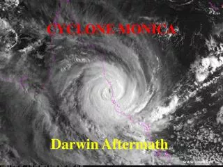
Inland Tropical Cyclone Impacts: Overview. Inland Winds Tornadoes Inland Flooding NWS Products/services to stay informed. Inland High winds. The strongest winds usually occur in the right side of the eyewall of the hurricane – but not always.

E N D
Inland Tropical Cyclone Impacts: Overview • Inland Winds • Tornadoes • Inland Flooding • NWS Products/services to stay informed
Inland High winds The strongest winds usually occur in the right side of the eyewall of the hurricane – but not always. Wind Gusts on top of sustained winds can significantly add to the destructive power! Wind speed usually decreases significantly within 12 hours after landfall. Nonetheless, winds can stay above hurricane strength well inland.
Tornadoes • Tornadoes with hurricanes: • Nearly 60% of hurricanes that make landfall spawn at least 1 tornado • In general, tropical tornadoes are less intense than those that occur in the spring and autumn • However, occasionally EF-2 or EF-3 tornadoes do occur • Tropical Systems allow for the potential of a significant number of tornadoes
Tornadoes add to the storm's destructive power! Likely in the right-front quadrant of the hurricane Can form with little or no warning Circulations are often smaller and short lived Storm motion
Tornadoes far from the Center Tornadoes can form up to several hundred miles northeast of the center
Additional Tornado Facts When associated with hurricanes, tornadoes are not usually accompanied by hail or a lot of lightning – often move west or northwest Tornado production can occur for days after landfall when the tropical cyclone remnants maintain an identifiable low pressure circulation.
2005 Storms and Tornadoes At least 221 tornadoes occurred in association with the 8 tropical cyclones (Arlene, Cindy, Dennis, Katrina, Ophelia [0 tornadoes], Rita, Tammy [0 tornadoes], and Wilma) that affected the United States.
Monitoring Tornado Threat A tornado watch is usually issued when tropical cyclone rain bands are about to move onshore. The watch box is generally to the right of the tropical cyclones path. A tornado warning is issued by local Weather Forecast Offices when a tornado is either detected on radar and/or sighted by spotters.
Watches and Warnings Inland Tropical Storm WatchIssued for interior counties when sustained winds of 39 to 73 mph associated with a tropical storm are possible within 48 hours. Inland Tropical Storm WarningIssued for interior counties when sustained winds of 39 to 73 mph associated with a tropical storm are expected within 36 hours. Inland Hurricane Watch Issued for interior counties when sustained winds of 74 mph or greater associated with a hurricane are possible within 48 hours. Inland Hurricane WarningIssued for interior counties that sustained winds of 74 mph or greater associated with a hurricane are expected within 36 hours. Extreme Wind Warning Issued for area when eye wall of Category 3 or higher storm will impact the area within one hour – used very rarely
Inland Flooding Heavy rainfall often extends well inland Storms can move very slowly…stall and/or interact with frontal boundaries to enhance rainfall rates Heaviest rainfall is often at night around the center and away from the center in the day Flash Flooding/River Flooding – lasts several days Flash Flood Watches issued ~24 hours in advance Flash Flood Warnings issued prior to flooding Flash Flood Emergency when rare flooding/ water rescues occurring
WFO Hurricane Local Statements (HLS) Bringing all the forecasts together Local WFOs analyze TPC/NHC products and issue Hurricane Local Statements (HLS), which contain (for inland areas): • Counties, parishes, or cities included in the HLS • Watches and/or warnings in effect • Present winds and the expected time of onset of tropical storm or hurricane force winds • Tornado, flash flood, inland high wind potential • Recommended precautionary actions
WFO Briefings • Some briefings done using GoToMeeting and some over 800 mHz radio (Alabama) • Discuss the specifics of the storm for local and state Emergency Management (EM) – personal touch • Can answer any questions if there is confusion • EMs can get a feel for uncertainty and expected severity of the event that text products/graphics do not provide • Some have brought local officials into the briefing to hear what the NWS is saying – helps add credibility to what the EMs are telling the officials