Download
1 / 12
120 likes | 123 Views
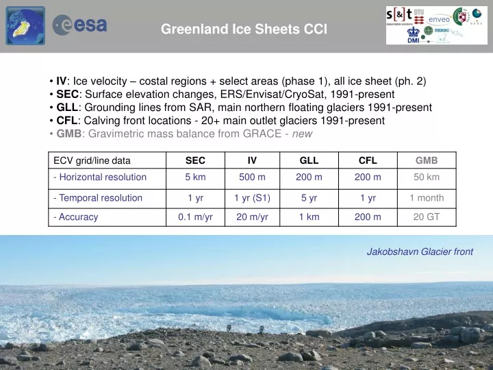
Greenland Ice Sheets CCI. IV : Ice velocity – costal regions + select areas (phase 1), all ice sheet (ph. 2) SEC : Surface elevation changes, ERS/Envisat/CryoSat, 1991-present GLL : Grounding lines from SAR, main northern floating glaciers 1991-present

E N D
Greenland Ice Sheets CCI • IV: Ice velocity – costal regions + select areas (phase 1), all ice sheet (ph. 2) • SEC: Surface elevation changes, ERS/Envisat/CryoSat, 1991-present • GLL: Grounding lines from SAR, main northern floating glaciers 1991-present • CFL: Calving front locations - 20+ main outlet glaciers 1991-present • GMB: Gravimetric mass balance from GRACE - new Jakobshavn Glacier front
Velocity [m/d] Greenland-wide IV coverage (Enveo) ECV release Dec 2015 Sentinel 1 IWS SLC Period: Nov 2014-Dec 2015 (mainly winter scenes) Arrangements agreed with ESA for several yearly data acquisitions => Time series of frequent epochs possible (but processing intensive!)
Google earth data IV SEC
Grid filtering – merged product 15 km/5 cm 0.1 filter Grid errors
Envisat 2006-10 Details (10 km filtering)
CryoSat CCI 2010-14
CryoSat 2010-14 dh/dt - details zoom in 79 Glacier Zachariae Storstrømmen Method: Custom treshold Level-1 retracking of SARin and SAR mode data (J. Nilsson) 5 km resolution stacking w.r.t. reference DEM (iterative) [m/yr]
GMB issues: Greenland vs Canada Greenland mass trend 2002-15: -244 GT/yr (excl. Canada) Solving for Greenland mask alone: ~ -300 GT/yr … too large Absolute trend values of Greenland depends strongly on whether East Canadian ice caps are included or not .. express leakage problems Mass loss of Greenland increased by ~100 G/yr around 2010 … (2012 extreme melt event)
GRACE issues: Validation with SEC? GRACE 2003-12 (DTU Masscons) Envisat (CCI) and GRACE merged solution Overall mass loss (excl Canadian ice caps) ~ 250 GT/yr ~ 0.7 mm global sea level rise
Ice Sheet CCI users ... • Coupled ice sheet / climate models • (e.g. DMI, European/US groups) • Validation of Surface Mass Balance • and ice flow models – glaciologists • General public, stakeholders: • - Ice Sheet changes major indicator of • climate change / global sea level rise • Monitoring programs (PROMICE) • Scientists … easier access to data CCI ECV Status Feb 9, 2016:. CFL: 45 downloads, GLL: 43 downloads, IV: 147 downloads (5 products) SEC: 60 downloads
Phase 2 / Year 1 ECV’s + Options • GMB: • - Monthly values mass loss, 2002-present • Zwally basin time series, total mass loss, • Maps (50 km resolution) .. Greenland only • IV: • 2nd Greenland-wide S-1 grid, 2012-13 RadarSat grid • 7 ice streams • Optical fill-in • SEC: • Continue yearly dh/dt: CryoSat, AltiKa • New product: accumulate surface elevation change • 1992-present, ERS, EnviSat, CryoSat .. • Issues: • Antarctica methodology correspondence (Antarctica CCI) • Quantifying outlying Greenland glaciers (Glaciers CCI) • CFL, GLL: • Continue time series, S-1+ S-2 data utilization • CCI Options proposed: • Sea level closure (SL CCI, AIS CCI, GIS CCI, Glaciers CCI) … in prep. • High-resolution GMB product (GIS-CCI), combination of GRACE, altimetry, firn models