Download
1 / 41
410 likes | 413 Views
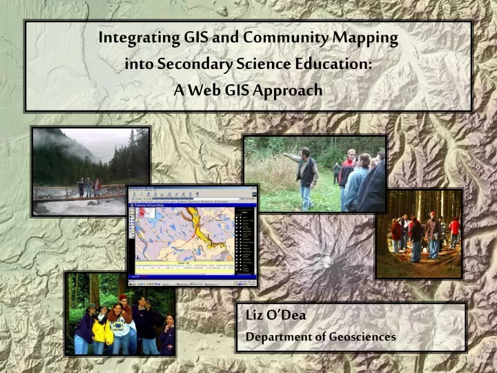
Liz O’Dea Department of Geosciences. Integrating GIS and Community Mapping into Secondary Science Education: A Web GIS Approach. Introduction. GIS: program combining mapping, data, and analysis tools GIS and Secondary education Growing interest Slow growth in use

E N D
Liz O’Dea Department of Geosciences Integrating GIS and Community Mapping into Secondary Science Education: A Web GIS Approach
Introduction • GIS: program combining mapping, data, and analysis tools • GIS and Secondary education • Growing interest • Slow growth in use • Success limited (time, resources) • Time wasted teaching technology • Global data common, local data desired • Less complex GIS options needed
Web GIS as potential solution • What is web GIS? • Basic GIS functions with Internet technology • Accessible via the Web • Less complex interface • Easier to use as tool
Objectives • Is web GIS a viable option for GIS in education? • What are the benefits and limitations of web GIS use in education? • What are some factors of success?
The Tahoma Virtual Atlas • Model online physical geographic community atlas • Created for Tahoma School District’s secondary science classes • Developed using Arc Internet Map Server
Benefits of GIS in Education • Provides new perspective • Interactive nature increases learning • Ideal for student-centered classrooms • Problem solving and spatial reasoning skills • Interdisciplinary = “real world” • Complements science curriculum nicely • Exposure to modern mapping methods
Current Status • 2% of high schools own a GIS • Only half of those schools use it
Why so low? • Full GIS too technical for most teachers • Time consuming: • Learning • Teaching (takes away from core curriculum) • Lack of resources • Training • Adequate technology • Money to support these • Few curriculum resources
Efforts to Increase Use • Organizations • Nonprofit, government, university • Software • ArcExplorer, ArcVoyager • Trainings
Web GIS • Recent technology • Static maps vs. functionality • Local GIS programs and data not required • Used by GIS novices and experts • Can be tailored to meet needs
Arc Internet Map Server (ArcIMS) • Advanced web GIS • Product of ESRI • Simplified ArcView • Basic GIS functions • Single interface • Uses ArcView Shapefiles
Viewers Client Server Web Server ArcIMS Connectors Application Server Spatial Server Manager
The Tahoma Virtual Atlas • Tahoma School District, Washington • Online physical geographic community atlas • Secondary integrated science curriculum • Tool that compliments field trips
Planning • Initial design: • Physical geographic theme • Integrated: geology, hydrology, climate, vegetation • Pierce and King Counties • Field trip locations • Goals: • Provide teachers access to local data • Tool to build upon
Data Compilation • Internet download, CDs, tables • Acquired from various sources • County governments • University of Washington • Federal Government Agencies (BLM, USFS, USGS) • Created (contours, slope, aspect, earthquakes)
Data Processing • Most time consuming • Many formats, projections • Final format: • State Plane WA, North Zone Projection • ArcView Shapefiles • grids and images: GeoTIFF format
Data challenges • Scale issues • Original scale: large = more detail • Joining Layers • Matching features • Matching tables • Differing scales • Most added separately (too time consuming)
ArcIMS Installation • ArcIMS 3.1 Installed • Dell Precision Workstation • Windows 2000 Workstation • Requires web server and Java components to be installed first • Apache Web Server, Jakarta Tomcat • Secure and stable • Long, painful process
Site Creation • ArcIMS Manager easy to use
Site Customization • Default site unattractive • Manual edits to HTML and JavaScript files: • Changed colors • Added links to accessory pages created: • Introductory page • Help page • Metadata page • Disclaimer
Page Overview Overview Map Layers/ Legend Toolbar Map Frame Mode Frame Text Box Links
Implementation • Introduced atlas to teachers • brief training • Sample lesson • Survey • Teacher using in class 3 days later! • Migration from OSU to high school • Train future site manager
The Final Product • Many functions: • Choose layers to display • Zoom/pan • Identify, search, query features • Measure, buffer features • Print layout
Uses of the atlas • Enhance science lessons with local data • Volcanic activity, earthquakes • Watershed studies • Mapping skills • Local affects of global warming • Investigate study sites • Add new layers • Develop temporal database (i.e., water quality)
Data Observations • Factors of consideration • Scale • Quality • Metadata quality variable • Area too large
ArcIMS Observations • Challenging to install • IMS Manager and site sometimes quirky • Slow site speed = frustrated students • Customization challenging • Need programming skills • Maintenance may be too challenging for teachers
Web GIS in Education • Addresses time issues: • Less training needed • Focus on educational standards • Addresses resource issues: • Web browser only requirement • Use from any computer • Lead to increased GIS use in education • Same data sets accessible with ArcView
Community Mapping • Local data more interesting • Students relate better • Local issues Global issues • Incorporate hands-on learning • Create new data in the field • Web GIS makes access easier • Connect students with community
Conclusions • Not answer for everyone • As technology improves, feasibility will increase • Success depends on teachers
Conclusions (cont’d.) • Easy to access and use • Tool to enhance curriculum • Use ArcView for more depth • Atlas can be expanded • Web GIS and fieldwork = unique opportunity
Future Work • Curricula development • Follow-up study of use in classrooms • Create new atlas pages, tailored to lessons • Simpler web GIS = greater use
Thank You! http://www.geocities.com/gisliz2002


![Geoneutrino Radiometric Analysis For Geosciences [GRAFG]](https://cdn2.slideserve.com/4382941/slide1-dt.jpg)