Download
1 / 2
20 likes | 127 Views
A System of Hierarchical Monitoring Methods for assessing changes in the biological and physical state of intertidal areas. Partners The HIMOM team consists of developers and end users from coastal management: Brockmann Consult (coordination), Germany University St. Andrews, Scotland

E N D
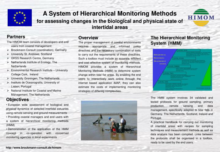
A System of Hierarchical Monitoring Methodsfor assessing changes in the biological and physical state of intertidal areas • Partners • The HIMOM team consists of developers and end users from coastal management: • Brockmann Consult (coordination), Germany • University St. Andrews, Scotland • GKSS Research Centre, Germany • Netherlands Institute of Ecology, The Netherlands • Environmental Research Institute – University College Cork, Ireland • University Groningen, The Netherlands • Instituto de Oceanografia, University of Lisbon, Portugal • National Institute for Coastal and Marine Management, The Netherlands Overview The proper management of coastal environments requires appropriate and informed policy directives and the necessary combination of tools to carry out the requirements of these directives. Such a toolbox must include an accurate, efficient and cost effective system of monitoring methods. HIMOM provides a system of Hierarchical Monitoring Methods (HMM) to determine system change within tidal flat areas. By enabling the end users to interactively work online through the internet based application iMAP, they can also estimate the costs of implementing monitoring strategies of differing complexities. The Hierarchical Monitoring System (HMM) The HMM system involves 34 validated and tested protocols for ground sampling, primary production, remote sensing and data management, specifically adapted to tidal flats in Germany, The Netherlands, Scotland, Ireland and Portugal. A practical handbook for carrying out monitoring of intertidal areas with recipes for sampling techniques and measurement methods as well as data analysis has been compiled. Links between the protocols shall be organised in a toolbox, ready to be used by the end users. • Objectives • European wide assessment of biological and physical dynamics of selected intertidal estuaries using remote sensing and ground measurements • Providing coastal managers and end users with a system of hierarchical monitoring methods (HMM) • Demonstration of the application of the HMM concept in co-operation with concerned monitoring agencies in local experiments http://www.brockmann-consult.de/himom
A System of Hierarchical Monitoring Methodsfor assessing changes in the biological and physical state of intertidal areas Ground truthing Field measurements are carried out every 2 – 3 months over 3 years in 4 different test sites spread over Europe. These seasonal measurements in each test site are performed in order to detect and compare changes throughout the years. In the scope of an intercalibration campaign different instruments and sampling as well as measurement methods were adjusted. During a simultaneous campaign in all test sites, the vertical migration of microphytobenthos was analysed. Remote Sensing Spectral reflectances, which are measured regularly as standard parameter within the HMM, links the in-situ measurements with remote sensing data such as CASI or Landsat images. Methods like NDVI, linear spectral unmixing or supervised classification are used in order to retrieve sediment classifications and assessment of microphytobenthos in different scales. Landsat images of the estuaries of each test site have been classified and compiled to the HIMOM Estuary Atlas. Link to End Users The link to end users is performed on the one hand through the Book of Protocols and on the other hand through the HIMOM iMap, which is designed as an interactive tool for making geoinformation available via the internet. Because monitoring data have both - a spatial and temporal dimension, special treatment of these data are required. The main purpose of the iMap is to allow end users to visualise and interpret this data immediately and together with other data sets including easy data up- and download. Visual interpretation and queries on all (spatial and non-spatial) data is possible, as well as presenting data in graphical form such as for example time series or reflectance spectra measured at different measurement points.