Download
1 / 21
210 likes | 302 Views
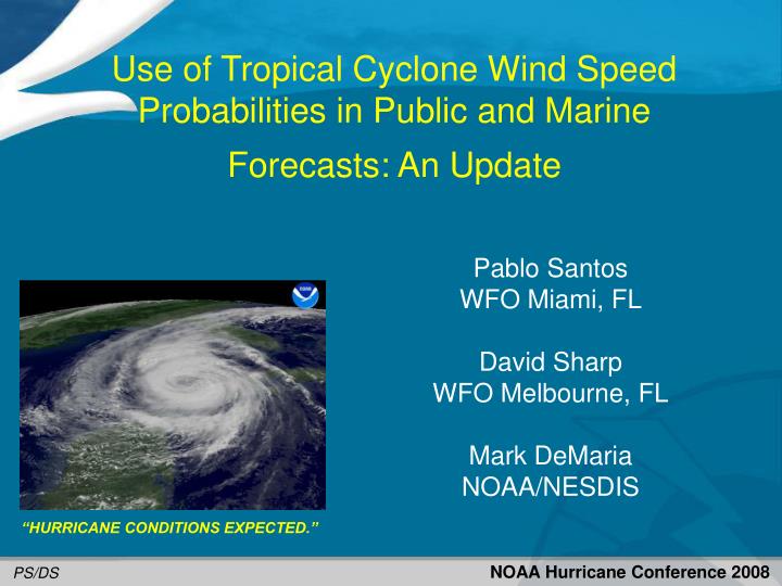
Use of Tropical Cyclone Wind Speed Probabilities in Public and Marine Forecasts: An Update. Pablo Santos WFO Miami, FL David Sharp WFO Melbourne, FL Mark DeMaria NOAA/NESDIS. “HURRICANE CONDITIONS EXPECTED.”. NOAA Hurricane Conference 2008. PS/DS. Contents of Presentation.

E N D
Use of Tropical Cyclone Wind Speed Probabilities in Public and Marine Forecasts: An Update Pablo Santos WFO Miami, FL David Sharp WFO Melbourne, FL Mark DeMaria NOAA/NESDIS “HURRICANE CONDITIONS EXPECTED.” NOAA Hurricane Conference 2008 PS/DS
Contents of Presentation • Brief Background Review • Methodology • 2008 Season Cases • Verification of Incremental Probabilities • The probability of sustained winds reaching or exceeding the specified threshold during the 12 hour forecast period ending at the specified forecast hour. • Future Plans
Message Sensitivity (Fostering One Forecast Message) Text Formatters: Logic HierarchyINTENT (Item 42-05): to establish a set of rules for triggering enhanced wording which responsibly conveys wind speed uncertainties within text forecasts Note: Forecast Error implies appreciation for the inherent uncertainties regarding the track, intensity, and size of the tropical cyclone.
Baseline Phraseology (Text Formatters) • Note: • The phrases with * above are equivalent to imminent or ongoing conditions as • reflected in the 00-12 hour period simultaneously by the hazard, wind, and • probability grids. • The word EXPECTED is used in situations mainly during the Warning period, but is • also selectively used in the Watch period (e.g., Day 1 & 2, or out to period 4). • The word POSSIBLE is used during the extended period (e.g., Day 3 - 5), but is also • used in specific situations within Watch/Warning period. • Also, certain situations require compound phrases (e.g., Tropical Storm Warning with • a Hurricane Watch).
Methodology • Load Wind Grids with TCMWindTool and take care of any local editing issues to address background blending (gradient), wind gradients within the coastal zone, other local value-added adjustments, etc. • Next, compute Wind Gust Grids (use GFE SmartTools). • Then populate the IncrementalProbability Grids (PWS_Procedure). • If warranted, be sure to populate any Hazard Grids by using a combination of PlotTPCEvents (TCV) procedure and Make Hazard Tools. • Finally, publish your grids and then run the ZFP and CWF text formatters. QC and post-edit before sending. Publishing the grids automatically activates the point and click version too.
2008 Season Examples Feedback
2008 Summary of Issues • TPCWindSpeed Probabilities mapping problem. DR 20206. • Sites not updating probabilities every 6 hours (PWS_Procedure) or running the procedure too early. • Timeliness of Probability files (Around 20 minutes after advisory time). • Internet communication issues with grids and Internet support. • Forecasters not applying procedure with every advisory resulting in packages that employed the probabilistic wording and some that did not. • Forecasters freelancing with post editing outside the bounds of what the training discussed they should be doing. • Impression from field forecasters that Incremental Probability thresholds for hurricane conditions might be low. • Otherwise, feedback from field offices very positive in general. One field survey by WFO Brownsville showed 8 out of 11 respondents specifically used the terms of uncertainty from our forecast products.
Special Probability Verification for WFO Application • Rerun 2008 MC model for all cases 2004-2008 with continental U.S. hurricane warnings • Include runs up to 3 days prior to 1st warning • 401 runs from 19 storms • Calculate 12 hr incremental probabilities at 343 coastal breakpoints locations • Use standard probabilistic skill metrics to optimize probability thresholds for WFO application • Threat score and ROC diagrams • Preliminary results for 64 kt probabilities
Pt Optimization Procedures • Threat Score • Threat Score useful for low probability events since it does not include No-No cases • TS ranges from 0 to 1 (1 is best) • Pick Pt that maximizes TS • Hit Rate/False Alarm Rate • Plot HR vs. FR in 2-D plane for range of Pt • Relative Operating Characteristic (ROC) diagram • Pick Pt for point closest to upper left corner in ROC diagram • Upper left corner has Hit Rate=1, False Alarm Rate=0
Optimal 64 kt Probability Thresholds based on Threat Score and ROC Diagram
Future - 2009 Season • Every site will have OB9. In OB9 formatters were re-designed for better integration with baseline ZFP and CWF formatters. In order for this last base lining step to be successful, FOCAL POINTS MUST follow the procedures outlined here as a post install after they upgrade to OB9: • http://www.nws.noaa.gov/os/vtec/GFEOB9Changes.html#Trop • So the question is where do we go from here?
Future – 2009 Season • Complete Incremental Probabilities verification for 34 knots and verify using other metrics. Adjust thresholds currently used accordingly and run tests with old and new thresholds. • Propose going official with this capability with ZFP/CWF and point and click pages in 2009. This will require: • WSH look into status of DR 20206. • Coordinate any needed changes to the public and marine directives with those programs to support transition to official. Preliminary conference call on this topic was held prior to even the 2007 season. • Conduct formal training with all coastal offices and associated inland offices using modules already developed by Dave and Pablo to support transition. • Provision for proper support for point and click in case something goes wrong. If this capability is adopted officially this will need to be communicated to Bungee’s group. • Expand capability to tabular products, specifically, the PFM. Enlist help of Tracy Hansen if needed to more effectively accomplish this. I believe this is doable for next season. • Propose Wind Team reconvene to discuss all these.
Zones Gustav – WFO LIX
Conversion of Probabilities into Yes-No Forecast • Pick probability threshold (Pt) • If P ≥ Pt, forecast YES • If P < Pt, forecast NO • Best choice of Pt depends on particular application • Use appropriate validation metric to select Pt objectively • Metrics determined from contingency table
Observed Yes No Yes Forecast No a b c d Contingency Table for Validation of Yes-No Forecasts Threat Score (TS) = a/(a + b + c) Hit Rate (HR) = a/(a + c) False Alarm Rate (FR) = b/(b + d)
Threat Score vs. Probability Threshold 24-36 hr Incremental Probabilities Optimal Probability Threshold = 19%
ROC Diagram for 24-36 hr Incremental Probabilities Optimal Probability Threshold Pt = 4% Pt=1% Pt=0% Pt=100%