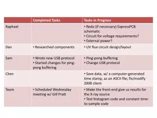
Download
1 / 16
170 likes | 292 Views
INSPIRE DS Stream Data Specification Elevation v2.0. Jordi Escriu Paradell - TWG EL Editor Institut Cartogràfic de Catalunya (ICC) INSPIRE Conference 2011 Edinburgh, 29 th June -1 st July 2011. This presentation. TWG Elevation INSPIRE Data Specification Elevation (v2.0) Overview

E N D
INSPIRE DS StreamData Specification Elevation v2.0 Jordi Escriu Paradell - TWG EL EditorInstitut Cartogràfic de Catalunya (ICC) INSPIRE Conference 2011Edinburgh, 29th June -1st July 2011
This presentation • TWG Elevation • INSPIRE Data Specification Elevation (v2.0) • Overview • Elevation theme • Reference materials • Scope • Results and achievements • Key aspects • UML Model • Open issues INSPIRE DS Stream – Data Specification Elevation v2.0
TWG Elevation Michael Hovenbitzer (Facilitator) Jordi Escriu Paradell (Editor) Chris Howlett Dave Capstick Eduardo González Gyula Iván Lee Brinton Lynne Allan Rogier Broekman Tim Kearns Veijo Pätynen Vincent Donato Zdzislaw Kurczyński Katalin Tóth (EC- JRC contact point) May 2010 – TWG EL Kick-off Meeting Frankfurt Nov 2010 – TWG EL Meeting Warsaw End Nov 2010 – Delivery of DS EL v1 March 2011 – TWG EL Meeting Barcelona June 2011 – Delivery of DS EL v2 April 2012 – Delivery of DS EL v3 IIIIII II III IV I II III IV 2010 2011 2012 INSPIRE DS Stream – Data Specification Elevation v2.0
Elevation theme • Definition “Digital elevation models for land, ice and ocean surface. Includes terrestrial elevation, bathymetry and shoreline.” [INSPIRE Directive, 2007/2/EC] • Description “The theme includes: Terrestrial elevation(namely land-elevation), represented as: • Digital Terrain Models (DTM) describing the three-dimensional shape of the Earth’s surface (ground surface topography). • Digital Surface Models (DSM) specifying the three dimensional geometry of every feature on the ground, for example vegetation, buildings and bridges. Bathymetry data, e.g. a gridded sea floor model” [Adapted from INSPIRE Feature Concept Dictionary] INSPIRE DS Stream – Data Specification Elevation v2.0
Elevation theme • Relationships with other INSPIRE themes • Geographical names – Summits, mountain passes, singular spots • Hydrography / Administrative Units – Data consistency • Sea Regions – Shoreline (Coastline) • Buildings / Utility and governmental services / others… • Properties storing absolute elevations • Identification of the Vertical CRS to which these are referenced • Orthoimagery (& others using grids) • Modelling of Grids as coverages • Use cases of many themes use Elevation data as input for spatial analyses (EL present in 11 use cases) INSPIRE DS Stream – Data Specification Elevation v2.0
Reference materials Reference documents • 36 received and analysed User requirements survey • 44 received • 4 Key use cases selected • Flooding • Orthoimagery production • Safety in maritime and hydrographic navigation • Elevation mapping INSPIRE DS Stream – Data Specification Elevation v2.0
DS Scope • In the scope • Content • Land elevations: • Absolute gravity-related heights • Bathymetry • Sea and inland water bodies depths • Modelling of surfaces • 2.5-D, only one value per planimetric position • Either a Digital Terrain Model (DTM) or a Digital Surface Model (DSM) • Data representations • Vector data (2-D and 3-D geometries) • Gridded data (coverages) • TIN data • Out of the scope • Measurement procedures from which elevation properties are gathered • Bathymetry of river courses • Coastline • INSPIRE Data Specifications on Sea Regions, ‘CoastLine’ Feature type INSPIRE DS Stream – Data Specification Elevation v2.0
Key aspects (I) • Homogenous / Integrated approach to • Land elevation and bathymetry data (elevation properties) • Representation of different surfaces: DTM, DSM • Different spatial representation forms: Vector, Grid, TIN • Identifier management • Unique identifiers mandated for vector spatial objects, grid coverages and TIN structures • Object life-cycle information (voidable) • beginLifespanVersion / endLifespanVersion • Coordinate Reference Systems (requirements / recommendations) Identification of the Vertical CRS is needed! - Mechanism provided in the EL model INSPIRE DS Stream – Data Specification Elevation v2.0
Key aspects (II) • Cross-border interoperability (Grids): • Main Issues: • MS Data is stored using national grids (different CRSs and map projections) – This makes necessary to perform transformations with their inherent quality lose. • National grids uses different grid cell alignment rules. • Possible solution to fix these issues • Provide Elevation data using a Common European / Global Grid. • Existing common grid • Grid_ETRS89-LAEA, established as the multipurpose Pan-European standard by the IR on Data Interoperability (Annex I - DS on Geographical Grid Systems). • Based on the ETRS89 Lambert Azimuthal Equal Area CRS (ETRS89-LAEA) • Main purpose: Framework for spatial analysis and reporting • Not appropriate for Elevation data • PROPOSAL: European Common Grid for Raster Data (Grid_ETRS89-GRS80) • Hierarchical grid based on ETRS89-GRS80 geodetic coordinates • Common set of rules assuring aggregation of grid cells (grid origin, grid cell reference point) • Recommended for provision of EL and OI data aimed at cross-border purposes (DS Annex C) • Aligned with the IR (Section 2.2.2): Other theme-specific grids may be specified Data based on national grids is totally valid within their geographical scope! INSPIRE DS Stream – Data Specification Elevation v2.0
UML Model - Structure INSPIRE Directive ISO Standards INSPIRE Generic Conceptual Model D2.5 Coverages (Domain and Range)App. Schema Elevation - Base App. Schema Elevation – Vector Elements App. Schema Elevation - Coverages App. Schema Elevation - TIN App. Schema INSPIRE Elevation Data Product Specification D2.8.II.1 INSPIRE DS Stream – Data Specification Elevation v2.0
UML Model – Application schemas Elevation - Base Describing… • Basic classes • ‘ElevationDataSet’ • Generic components • Common types [Data types] • Vertical CRS identification ‘ElevationCRSReference’ [Code lists & enumerations] • Elevation property type ‘height’ / ‘depth’ • Surface type ‘DTM’ / ‘DSM’ INSPIRE DS Stream – Data Specification Elevation v2.0
UML Model – Application schemas Void Area Elevation – Vector Elements Describing… • Generic abstract class • ‘ElevationVectorObject’ • Specialized features types • Points ‘SpotHeight’, ‘SpotDepth’ • Lines ‘ContourLine’, ‘DepthContour’ • Auxiliary objects ‘BreakLine’, ‘VoidArea’, ‘IsolatedArea' Isolated Area Elevation Vector Object Break Line Spot Height Points Lines Spot Depth Contour Line Depth Contour INSPIRE DS Stream – Data Specification Elevation v2.0
UML Model – Application schemas Elevation – Coverages (Grids) Describing… • Main class • ‘ElevationGridCoverage’ • Elevation property / Surface • ‘height’ / ‘depth’ • ‘DTM’ / ‘DSM’ • Conformity to • Generic Conceptual Model (GCM) • ISO 19123:2005 – Coverages geometry and functions • Current draft of WCS 2.0 INSPIRE DS Stream – Data Specification Elevation v2.0
UML Model – Application schemas Elevation - TIN Describing… • Main class • ‘ElevationTIN’ • Elevation property / Surface • ‘height’ / ‘depth’ • ‘DTM’ / ‘DSM’ • Conformity to • ISO 19107:2003 – Spatial Schema Type ‘GM_Tin’ INSPIRE DS Stream – Data Specification Elevation v2.0
Open issues • Bathymetry of river courses • Not in the current scope of the DS – Needed for relevant use cases like e.g. safety of inland navigation? • Cross-theme data consistency • Not clear how to achieve positional / logical consistency between data from different INSPIRE themes. • Elevation Vector and TIN cross-border data consistency • Must be further investigated by the TWG. • Grid coverage data aggregation • An integrated approach with TWG-OI is needed. • Requirements / recommendations on depth measurement– Under discussion • For the vertical component measuring the depth of the sea floor, where there is an appreciable tidal range, the Lowest Astronomical Tide shall? be used as reference surface. In marine areas without an appreciable tidal range, in open oceans and effectively in waters that are deeper than 200 m, the depth of the sea floor shall? be referenced to the Mean Sea Level. • For the vertical component measuring depths above the sea floor in the free ocean, barometric pressure shall be used. • Data quality • Target results for DQ measures and recommended evaluation procedures. • Metadata • Mandatory / Optional theme-specific metadata elements - Under discussion. • Guidance on specific MD elements – e.g. template for Lineage Looking for feedback from the Consultation & Testing Phase! INSPIRE DS Stream – Data Specification Elevation v2.0
Thank you for your attention!! jordi.escriu@icc.cat inspire-twg-el@jrc.ec.europa.eu INSPIRE DS Stream – Data Specification Elevation v2.0