Download
1 / 1
10 likes | 119 Views
An Improved Microwave Satellite Data Set for Hydrological and Meteorological Applications. Wenze Yang 1 , Huan Meng 2 , and Ralph Ferraro 2 1. UMD/ESSIC/CICS, College Park, MD Email : ywze98@umd.edu; 2. NOAA/NESDIS/STAR, College Park, MD. AMS2014 # 776.

E N D
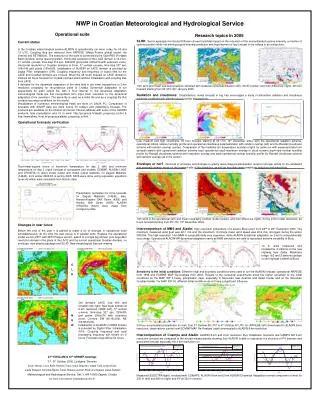
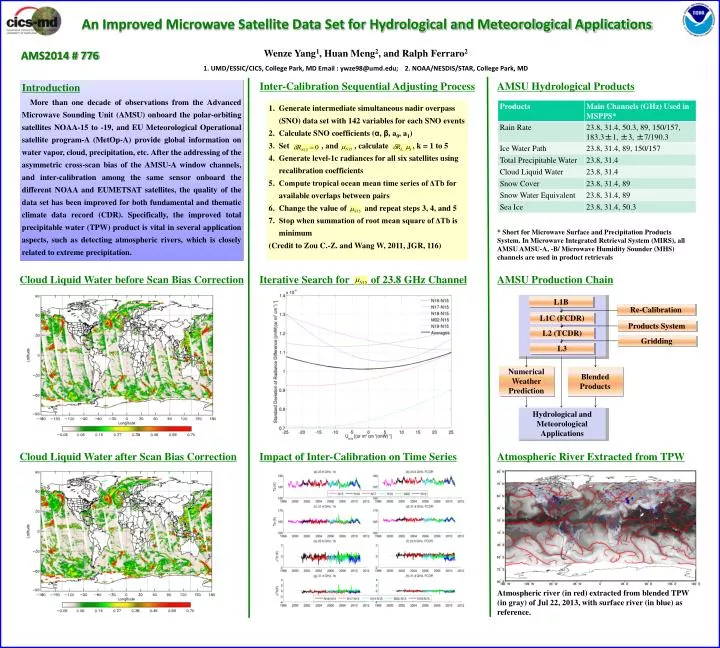
An Improved Microwave Satellite Data Set for Hydrological and Meteorological Applications Wenze Yang1, Huan Meng2, and Ralph Ferraro2 1. UMD/ESSIC/CICS, College Park, MD Email : ywze98@umd.edu; 2. NOAA/NESDIS/STAR, College Park, MD AMS2014 # 776 Inter-Calibration Sequential Adjusting Process AMSU Hydrological Products Introduction More than one decade of observations from the Advanced Microwave Sounding Unit (AMSU) onboard the polar-orbiting satellites NOAA-15 to -19, and EU Meteorological Operational satellite program-A (MetOp-A) provide global information on water vapor, cloud, precipitation, etc. After the addressing of the asymmetric cross-scan bias of the AMSU-A window channels, and inter-calibration among the same sensor onboard the different NOAA and EUMETSAT satellites, the quality of the data set has been improved for both fundamental and thematic climate data record (CDR). Specifically, the improved total precipitable water (TPW) product is vital in several application aspects, such as detecting atmospheric rivers, which is closely related to extreme precipitation. Generate intermediate simultaneous nadir overpass (SNO) data set with 142 variables for each SNO events Calculate SNO coefficients (α, β, a0, a1) Set , and , calculate , k = 1 to 5 Generate level-1c radiances for all six satellites using recalibration coefficients Compute tropical ocean mean time series of ΔTb for available overlaps between pairs Change the value of and repeat steps 3, 4, and 5 Stop when summation of root mean square of ΔTb is minimum (Credit to Zou C.-Z. and Wang W, 2011, JGR, 116) * Short for Microwave Surface and Precipitation Products System. In Microwave Integrated Retrieval System (MIRS), all AMSU AMSU-A, -B/ Microwave Humidity Sounder (MHS) channels are used in product retrievals Cloud Liquid Water before Scan Bias Correction Iterative Search for of 23.8 GHz Channel AMSU Production Chain L1B Re-Calibration L1C (FCDR) Products System L2 (TCDR) Gridding L3 Numerical Weather Prediction Blended Products Hydrological and Meteorological Applications Cloud Liquid Water after Scan Bias Correction Impact of Inter-Calibration on Time Series Atmospheric River Extracted from TPW Atmospheric river (in red) extracted from blended TPW (in gray) of Jul 22, 2013, with surface river (in blue) as reference.