Download
1 / 29
330 likes | 643 Views
Deep Convection: Classification. Deep Convection: Classification. Types of Convective Storms: Single Cell Storms Multicell Storms Supercell Storms. Single Cell Storms. The Convective Cell: Ordinary deep convective cumulonimbus (Cb) clouds

E N D
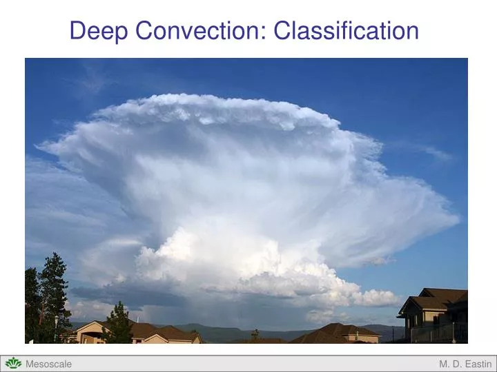
Deep Convection: Classification M. D. Eastin
Deep Convection: Classification • Types of Convective Storms: • Single Cell Storms • Multicell Storms • Supercell Storms M. D. Eastin
Single Cell Storms • The Convective Cell: • Ordinary deep convective cumulonimbus (Cb) clouds • Have been studied and documented since the late 1800s M. D. Eastin
Single Cell Storms • The Convective Cell: • First detailed documentation of “thunderstorms” • was by Horace Byers and Roscoe Braham • in the late 1940s • Documented all convection that occurred • during a 3-month period in a ~100 square • mile area near Orlando, FL • Data collection included 50 surface stations, • 6 balloon launch sites, radar, and aircraft • simultaneously flying at 5 altitudes • Results described the evolution of an ordinary • convective cell in three stages M. D. Eastin
Single Cell Storms The Convective Cell: Cumulus Stage: Developing cumulus cloud dominated by an updraft > 10 m/s Minimal updraft tilt No downdrafts Precipitation develops aloft and is suspended by updraft From Byers and Braham (1949) M. D. Eastin
Single Cell Storms The Convective Cell: Mature Stage: Cloud extends through depth of the atmosphere Anvil cloud begins to spread out near tropopause Downdraft develops due to precipitation loading and evaporational cooling Precipitation reaches the ground Leading edge of downdraft produces a gust front From Byers and Braham (1949) M. D. Eastin
Single Cell Storms The Convective Cell: Dissipating Stage: Precipitation core and downdraft wipe out the updraft Cell becomes dominated by a weak downdraft Light precipitation at the ground From Byers and Braham (1949) M. D. Eastin
Single Cell Storms • The Convective Cell: • Basic building block of all • convective systems • Lifespan is 30-60 minutes • Occur in environmentswith: • weak vertical shear (< 10 m/s), • variable CAPE (500-2000 J/kg), • and small CIN ( > -50 J/kg) • Motion is roughly the speed and • direction of the mean flow in the • 0-6 km AGL layer • Gust front spreads out equally in • all directions and rarely initiates • new convective cells • Can produce rain, hail, strong • winds, but rarely tornadoes M. D. Eastin
Single Cell Storms • The Convective Cell: • Basic building block of all • convective systems • Lifespan is 30-60 minutes • Occur in environmentswith: • weak vertical shear (< 10 m/s), • variable CAPE (500-2000 J/kg), • and small CIN ( > -50 J/kg) • Motion is roughly the speed and • direction of the mean flow in the • 0-6 km AGL layer • Gust front spreads out equally in • all directions and rarely initiates • new convective cells • Can produce rain, hail, strong • winds, but rarely tornadoes M. D. Eastin
Multicell Storms • The Multicell Storm: • A collection of single-cell storms • at various stages in their lifecycle • New cell development regularly • occurs on gust front flanks Cell 3 Cell 2 Cell 4 Cell 1 Cell 5 Note: These images are qualitatively consistent with one another M. D. Eastin
Multicell Storms • The Multicell Storm: • New cell development occurs on • the flanks of the gust front where • convergence with the ambient • storm-relative low-level flow is • maximized • Individual cell motion (Vc) may be • different than the overall storm • motion (Vs) • Individual cells continue to move • at the speed and direction of the • mean flow in the 0-6 km AGL layer • The storm may move at a speed • slower or faster than the mean • wind (and in a different direction) • depending on which flank has the • maximum convergence M. D. Eastin
Multicell Storms • The Multicell Storm: • Main inflow approaches the storm and • is lifted by the spreading gust front • By the time the updraft has reached the • tropopause (anvil cloud), it is often well • behind the leading edge of the gust front • Downdraft air originates at mid-levels from • precipitation loading and evaporational • cooling • Updraft and downdraft are well separated, • allows the system to live for a much • long time than a single cell M. D. Eastin
Multicell Storms • The Multicell Storm: • Common features include a shelf cloud, • overshooting tops, and an anvil cloud • Lifespan 2-12 hours • Occur in environmentswith: • moderate vertical shear (10-20 m/s) • variable CAPE (500-3000 J/kg) • small CIN (> -50 J/kg) • Can produce copious rainfall, hail, high • winds and some tornadoes along the • gust front Shelf Cloud Example M. D. Eastin
Multicell Storms • The Multicell Storm: • Often observed in a wide variety • of overall system structures • Examples include: • Squall Lines (all varieties) • Bow Echoes • Mesoscale Convective Complexes Examples of Multicell Storms on Radar From Houze (1993) M. D. Eastin
Supercell Storms • The Supercell Storm: • Single-cell storm that develops in isolation or • splits from a multicell storm • Defining characteristic is a single, quasi-steady, • rotating updraft – often observed by radar as • a strong “mesocyclone” and with a “hook” echo • Most rare, but most dangerous, storm type - can • produce large hail and strong, long-lived tornadoes From Houze (1993) M. D. Eastin
Supercell Storms • The Supercell Storm: • Life span up to 8 hours • Motion is often slower than and • to the right of the mean flow • in the 0-6 km layer • Occur in environments with: • strong vertical shear (> 20 m/s) • large CAPE (1000-4000 J/kg) • small CIN ( > -50 J/kg) M. D. Eastin
Supercell Storms • The Supercell Storm: • Early radar observations help identify many common structural characteristics during the mature stage of a supercell • Forward Flank Downdraft (FFD) • Strongest and largest of the downdrafts • Located below the primary anvil cloud • and separated from primary updraft • Associated with the most intense • precipitation and gust front • Rear Flank Downdraft (RFD) • Located adjacent to the primary updraft • Associated with mid-level mesocyclone • Collocated with the “hook” appendage • Both downdrafts are driven by water loading and evaporational cooling • Note how their two gust fronts create “meso-fronts” similar to an occluded low Storm Motion From Lemon and Doswell (1979) M. D. Eastin
Supercell Storms • The Supercell Storm: • Early radar observations help identify many common structural characteristics during the mature stage of a supercell • Primary Updraft (UD) • Helical in structure • Updraft speeds can reach 40-50 m/s • Located at the occlusion point of the • two intersecting gust fronts • Located within the “hook” structure Hook Echo (see thick black contour) • Distinct notch in the radar reflectivity • Location of maximum inflow • Location of primary updraft • Location of any tornado • Caused by the mid-level mesocyclone • advecting precipitation around itself • Good evidence of a mesocyclone • Also called an “inflow notch” Storm Motion Tornado (T) From Lemon and Doswell (1979) M. D. Eastin
Supercell Storms • The Supercell Storm: • Modern Doppler radar observations continue to show these common features as well as the strong rotation associated with the mid-level mesocyclone Mesocyclone Doppler Velocity Inbound Flow Outbound Flow Mesocyclone M. D. Eastin
Supercell Storms • The Supercell Storm: • Bounded Weak Echo Region (BWER) • Distinct “gap” of low reflectivity • in radar cross-sections • Location of the primary updraft • Caused by a very strong ascent • lofting all precipitation and hail • (that normally fall through the • updraft) to the upper levels • Updraft speeds must be • greater than 10 m/s • Located within the hook echo • Also called an “echo free vault” • Presence of a BWER • and a hook echo is good • evidence of a very strong • and rotating updraft • (i.e. a supercell) M. D. Eastin
Supercell Storms • The Supercell Storm: • Strong updrafts can produce • very large hailstones if the • updraft velocity is greater • than the fall velocity of the • hailstone (up to 20-30 m/s) • The “overhang” of a BWER, • observed in radar reflectivity, • is often composed of small • hailstones that are initially • ejected from the updraft at • upper levels, but fall back • into the strong updraft at • lower levels • This cycle can repeat itself • several times, allowing the • hailstone to grow larger • A hail trajectory example • might follow 1 → 2 → 3 From Chisholm and Renick (1972) M. D. Eastin
Supercell Storms • The Supercell Storm: • Often “split” into two separate storms • After the split, the motion of the storm • on the right (left) is to the right (left) of • the mean 0-6 km environmental flow • Called “right-movers” and “left-movers” • The right-mover usually continues as a • long-lived supercell (thanks in part to • continued access to the warm, moist • low-level inflow from the southeast), and • often experiences a slower forward speed • The left-mover usually begins to dissipate • (in part due to the right-mover blocking • access to the inflow), and often • experiences a faster forward speed • We will discuss the dynamical processes • involved with such events later…… Left Mover (LM) LM Mean Wind RM Storm Split Right Mover (RM) From Burgess (1974) M. D. Eastin
Supercell Varieties Classic Supercell • A Spectrum of Supercell Types: • Classic supercells • High-precipitation (HP) supercells • Low-precipitation (LP) supercells • Shallow (miniature) supercells • Classic Supercells: • Structure described on previous slides • Tend to occur in the Central Great Plains • and Midwest (west of Mississippi River) • Are capable of producing large hail, violent • tornadoes, and strong winds. M. D. Eastin
Supercell Varieties • High-Precipitation (HP) Supercells: • Produce more rain than classic supercells • Strongest RFDs and FFDs • Tend to be less isolated – located at the • southern end of squall lines • Often occur east of the Mississippi River • Are capable of producing large hail, weak • tornadoes (rain-wrapped), downbursts, • and flash floods Note the Elevation Angles M. D. Eastin
Supercell Varieties • Low-Precipitation (LP) Supercells: • Produce less rain than classic supercells • Weakest RFDs and FFDs • Tend to be smaller in diameter • Most often occur in the High Plains • along the dryline • Still capable of producing large hail, but • tornadoes are less common Note the Elevation Angles M. D. Eastin
Supercell Varieties • Shallow (or Miniature) Supercells: • Small diameter (<6 km) and shallow (<6 km) • compared to classic supercells • Most often occur in tropical cyclones • Small CAPE (<1000 J/kg) confined to • lower and middle levels • Strong shear (up to 30 m/s) in lower 3 km • Capable of producing weak tornadoes Miniature Supercells in Hurriance Ivan From Eastin and Link (2009) M. D. Eastin
Deep Convection: Classification • The following questions naturally arise…. • Given observations of the environment, which convective storm structure • should you anticipate? • Single cells • Multicells • Supercells • What environmental parameters should you look at? • Vertical Instability (CAPE and CIN…more in next lecture) • Vertical Shear (hodographs…more in next lecture) • What physical processes are responsible for the aforementioned storm • structure and evolution? (more to come…) M. D. Eastin
Deep Convection: Classification • Summary • Single Cell Storms • History • Three Stages (basic characteristics and structure) • Significance • Multicell Storms • Basic Characteristics and Structure • Motion and Propagation • Varieties • Supercell Storms • Basic characteristics • Defining structures • Motion and storm-splitting • Varieties (differences in structure and environment) M. D. Eastin
References Atkins, N.T., J.M. Arnott, R.W. Przybylinski, R.A. Wolf, and B.D. Ketcham, 2004: Vortex structure and evolution within bow echoes. Part I: Single-Doppler and damage analysis of the 29 June 1998 derecho. Mon. Wea. Rev., 132, 2224-2242. Byers, H. R., and R. R. Braham, Jr., 1949: The Thunderstorm. Supt. Of Documents, U.S. Government Printing Office, Washington, D.C., 287 pp. Burgess, D. W., 1974: Study of a right-moving thunderstorm utilizing new single Doppler radar evidence. Masters Thesis, Dept. Meteorology, University of Oklahoma, 77 pp. Chisholm, A. J. and J. H. Renick, 1972: The kinematics of multicell and supercell Alberta hailstorms. Alberta Hail Study, Research Council of Alberta hail Studies, Rep. 72-2, Edmonton, Canada, 24-31. Houze, R. A. Jr., 1993: Cloud Dynamics, Academic Press, New York, 573 pp. Klemp, J. B., and R. Rotunno, 1983: A study of the tornadic region within a supercell thunderstorm. J. Atmos. Sci., 40, 359-377. Lemon, L. R. , and C. A. Doswell, 1979: Severe thunderstorm evolution and mesocyclone structure as related to tornadogenesis., Mon. Wea. Rev., 107, 1184–1197. Weisman, M. L. , and J. B. Klemp, 1986: Characteristics of Isolated Convective Storms. Mesoscale Meteorology and Forecasting, Ed: Peter S. Ray, American Meteorological Society, Boston, 331-358. Wilhelmson, R. B., and J. B. Klemp, 1981: A three-dimensional numerical simulation of splitting severe storms on 3 April 1964. J. Atmos. Sci., 38, 1581-1600. M. D. Eastin