Download
1 / 27
270 likes | 446 Views
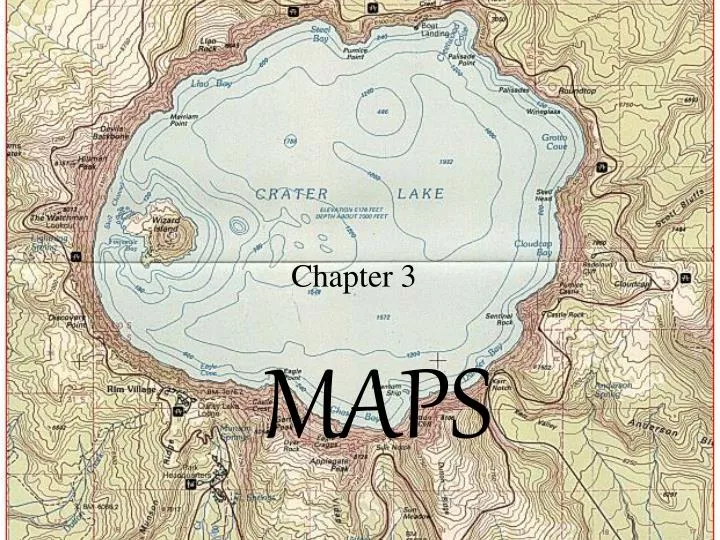
MAPS. Chapter 3. 3.1 Finding Locations on the Earth. Distinguish between latitude and longitude. Explain how latitude and longitude can be used to locate places on the earth. Explain how a magnetic compass can be used to find directions on the earth. Latitude:.

E N D
MAPS Chapter 3
3.1 Finding Locations on the Earth • Distinguish between latitude and longitude. • Explain how latitude and longitude can be used to locate places on the earth. • Explain how a magnetic compass can be used to find directions on the earth.
Latitude: 3.1 Finding Locations on the Earth • The distance in degrees north and south of the equator • Measured by parallels which are imaginary lines that circle the world. • The largest parallel is the equator • One degree of latitude is equal to 70 mi or 112 km.
Longitude: 3.1 Finding Locations on the Earth • The distance in degrees east or west of the prime meridian • Measured by meridians which are lines that runs from the north to the south poles. • The Prime Meridian runs through Greenwich, England, and is 0o longitude
Longitude • Locations east of the prime meridian have longitudes between 0◦ and 180◦ E • Locations west of the prime meridian have longitudes between 0◦ and 180◦ W
Longitude • The distance covered by a degree of longitude depends on where the degree is measured. The distance measured by a degree of longitude decreases as you move from the equator to the poles. • At 60 ◦ N one degree = 55 km • At 80 ◦ N one degree = 20 km
3.1 Finding Locations on the Earth Great Circles: • Divide the globe into halves • The shortest distance between two points on a globe • Used to plan air and sea routes
3.1 Finding Locations on the Earth Great Circles: • Divides the globe into halves • The shortest distance between two points on a globe • Used to plan air and sea routes
Finding Direction • Geomagnetic poles- the points on the earth’s surface just above the poles of the imaginary magnet inside the earth. A compass needle points to the geomagnetic North Pole • The Geographic North pole is located in a different place than the Geomagnetic pole. • Magnetic declination is the angle between the direction of the geographic pole and the direction in which the compass needle points • Boston Massachusetts-declination is 15 W of true north • San Antonio Texas- declination is 15 E of true north
3.2 Mapping the Earth’s Surface • Describe the characteristics and uses of three types of map projections. • Define scale, and explain how scale can be used to find distance on a map.
MAP PROJECTIONS, LOCATIONS, & SCALES real thing model ModelRepresentation of an object or idea Map Model of the earth’s surface on a sheet of paper
HOW DO WE MAKE A MAP WHEN THE EARTH IS ROUND?? Map Projection Transferring the curved surface of the earth onto a flat map 3 Major Types Mercator, Gnomonic, Conic
MAP PROJECTIONS • MERCATOR: • Shows the whole world • Shows true direction by straight lines. • Distortion is greatest at the poles.
MAP PROJECTIONS GNOMONIC: A projection made as if a sheet of paper were laid on one point on earth’s surface. Shows shortest route by straight line. Useful in plotting routes for air travel as it helps navigators find a great circle route. London to Tokyo
MAP PROJECTIONS CONIC: Nearly correct in all respects; this means latitude and longitude lines have a slight curve Best for showing the shapes of land masses Most accurate for making topographic maps
3.3 Topographic Maps • Explain how elevation and topography can be shown on a map. • Interpret a topographic map.
Important Features On A Topographic Map • Scale = shows the ratio of distance on the map to distance on the earth • Key / Legend = shows you what the symbols are on a map • Directional Compass = shows true north • Mileage Chart = shows common places on a map and how far they are apart
Important Features On A Topographic Map • Elevation is shown by contour lines. • Contour Interval = the difference in the elevation between adjacent contour lines. • Depression Contours = contours that show a lower area on a map; shown with closed contour lines that contain hachure marks on the inside.
Important Features On A Topographic Map • Bench Mark/Spot Elevation = place on a topographic map that shows exact elevation above sea level • Magnetic Declination = is the difference in degrees between magnetic north and true north. • Gradient = change in elevation in feet divided by the distance in miles
MODERN METHODS OF MAPMAKING • Remote sensing • Computer imaging • Use of computer-drawn maps and images