Download
1 / 12
140 likes | 252 Views
Existing Lunar Datasets. M. S. Robinson School of Earth and Space Exploration Arizona State University. Earth Based Telescopes Ranger Surveyor Lunar Orbiter Apollo Photography handheld automated Apollo Laser Altimetry Apollo Elemental Soviet Surface Imaging. Lunar Datasets.

E N D
Existing Lunar Datasets M. S. Robinson School of Earth and Space Exploration Arizona State University School of Earth and Space Exploration
Earth Based Telescopes Ranger Surveyor Lunar Orbiter Apollo Photography handheld automated Apollo Laser Altimetry Apollo Elemental Soviet Surface Imaging Lunar Datasets • Earth Based Radar • Clementine • Imaging, topography • Lunar Prospector • Elemental maps • Gravity • Global Control Network • Chang’e, Kaguya • Chandrayaan 1, LRO Review relevant image datasets, existing and upcoming
Lunar Orbiter • Best existing global BW morphology dataset (60 m/pix near and ~300 far m/pix) • USGS LO negatives global map scan project “completed” • High resolution mapping of equatorial regions (LO 1,2,3) • Synoptic mapping (LO 4) • High-resolution coverage of science targets (LO 5) • High Resolution LO Coverage: • ~1m/pixel of 1% of Moon • ~10 m/pixel covers ~12% • Nearside at ~60 m/pixel • Farside ~300 m/pixel • Quality varies http://astrogeology.usgs.gov/Projects/LunarOrbiterDigitization/
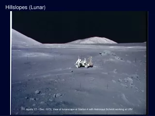
AS15-M-0284 Apollo 14 at Frau Mauro Apollo Photography 1968-1972 • Handheld 70-mm • 10,000 Color • 10,000 BW • Orbit, surface • Metric Camera (Ap 15-17) • BW, 127 x 127 mm (~8m/pixel) • Panoramic Camera (Ap 15-17) • BW, 127 mm x 1 m (1m/pixel) • 35-mm, Ap 14 Hycon, surface stereo… • JSC/ASU Apollo Flight Film Scanning Project underway!! • All flight films scanned by end 2009 • Accessible online at: HTTP://apollo.sese.asu.edu
Apollo Metric/Pan Camera Coverage True stereo, incidence angle ranges from 90° to near 0°, simultaneous laser altimeter point (~10,000 negatives). Panoramic camera footprints very similar (~4800 negatives). Full resolution digital scan project in progress! See information in registration folder.
UVVIS (CCD) 100-200 m/p global 5 filters (415-1000 nm) NIR (InSb) 160-320 m/p global 6 filters (1100-2800 nm) HIRES (CCD) 25-50 m/p (effective) 4 filters (415-750 nm) BW poles, selected color strips LWIR (HgCdTe) 200-400 m/p global broadband (8000-9500 nm) LIDAR Ranging (2.5° spatial, 100 m vertical, 65S to 65N) Clementine 1994 UVVIS Nearside High Sun for Color Analysis
Chang’e • Stereo Camera 120 m/p • 200x200 km orbit • Launched Oct 2007, 1 year nominal mission • Terrain Mapping Camera (TMC) 5 m resolution (40 km swath) global map of the Moon • To be launched mid-2008 Chandrayaan
Kaguya (Selene) • Launched Oct. 2007, 3 spacecraft • 100 km circular polar orbit • Terrain Camera Broadband Stereo 10 m/p, +- 15° forward and aft, planned global mapping • Multi Band Imager (20/62 m/p, VIS/NIR) • HDTV • http://www.selene.jaxa.jp/index_e.htm • Data release one year from end of nominal mission
Earth Based Radar • 20 to 40 m/pixel imaging and topography of lunar poles • Nearside only • Estimate illumination conditions over time Topography near Shackleton (S. Pole)
Lunar Reconnaissance Orbiter 2008 • LROC: Global WAC UV-VIS imaging 100 m/pixel; NAC BW 10% Moon at 0.50 m/pixel • LOLA: Globaltopography • LEND: Neutron flux (water ice) • DLRE: Temp. of lunar surface • LAMP: Search for surface ices in polar regions • CRaTER: Lunar radiation environment • Mini-RF: SAR (image permanently shadowed areas)
Lunar Reconnaissance Orbiter Camera • 2 Narrow Angle Cameras (NACs) for Landing Site Certification • 1000s of potential landing site observations at 0.5 m/pix • Polar mosaics (85.5 to 90) at 1 m/pix • Conventional and photometric stereo observations for 2 to 10 m/pix topography • Wide Angle Cameras (WAC) to Monitor Polar Lighting and Map Resources • Every orbit image each pole: BW 100 m/p • Global BW 100 m/p >50° incidence coverage • Global 7-color (100/400 m/p), 10° to 40° incidence • Special Observations (context, phase experiments, stereo)
What is NeededPrior to Human Return • Uniform global geodetic control network • Uniform global high resolution mineralogic and compositional data • Uniform global high resolution morphology data • Uniform global regolith characterization • Local very high resolution imaging of landing sites • Local very high resolution topography of landing sites