Download
1 / 27
280 likes | 551 Views
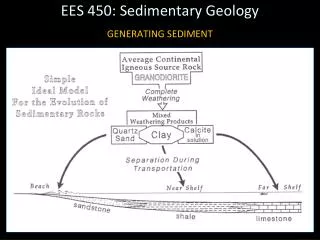
EES 450: Sedimentary Geology. Watersheds and Basins. EES 450: Sedimentary Geology. WATERSHEDS AND BASINS ● Watershed : An area that collects and drains rain water = sediment source area. - Prior to 1900, the Missouri-Mississippi River system supplied ~400 million metric tons of

E N D
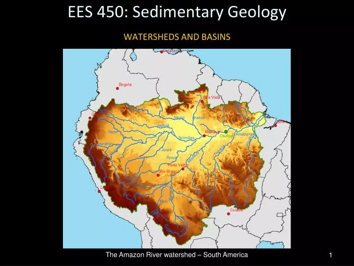
EES 450: Sedimentary Geology Watersheds and Basins The Amazon River watershed – South America
EES 450: Sedimentary Geology WATERSHEDS AND BASINS ●Watershed: An area that collects and drains rain water = sediment source area. -Prior to 1900, the Missouri-Mississippi River system supplied ~400 million metric tons of sediment per year to the Gulf of Mexico. From the late 1980’s on, transport has averaged ~145 million metric tons per year. Why?
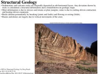
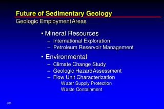
EES 450: Sedimentary Geology WATERSHEDS AND BASINS ● Earth’s surface is partitioned into areas of erosion and deposition. Areas of deposition are called sedimentary basins. - Both erosion and deposition occur across a very wide range of spatial scales, including within watersheds of various sizes. Think about an example of spatial scale independence in sedimentary geology? - Manifestations of the scale of sediment transport to and deposition within Earth’s largest sedimentary basins (oceans) are manifest globally by, for example, Holocene-age river deltas (next). GIS-based model of erosion (warm colors) and deposition (cool colors) within part of one watershed.
EES 450: Sedimentary Geology WATERSHEDS AND BASINS Amazon River Nile River Mississippi River Lena River Mekong River Ganges-Brahmaputra River
Interpretive Process Units Geologic Processes Geologic Units EES 450: Sedimentary Geology Weathering & Erosion Watershed Source WATERSHEDS AND BASINS ●The usefulness of multiple perspectives... Sedimentary Basin Sink Deposition
EES 450: Sedimentary Geology WATERSHEDS AND BASINS ● A fundamental link between erosion, deposition and tectonics is slope. - Tectonics often creates topographic highs (uplift), which = sediment sources, as well as topographic lows (subsidence) that collect sediment. - Energy to transport sediment from source to sink comes from the elevation difference between these two areas, and this difference is commonly expressed as the slope or gradient. Potential Energy PE = G x M x H Base level
EES 450: Sedimentary Geology WATERSHEDS AND BASINS ●Accommodation Space: That space made available in a sedimentary basin for potential sediment accumulation. It is dependent upon: (1) Sea level rise: Mostly glacio-eustatic over geological time (?). Are there other important drivers in the contemporary sense? (2) Subsidence: Can be driven by many processes, including crustal cooling, tectonics, isostasy, sediment or hydrostatic loading, autocompaction (including diagenetic processes via biological [metabolic] or chemical [remineralization] modifications) or fluid withdrawal. Where would you expect each to be important? (3) Combination of the two.
EES 450: Sedimentary Geology WATERSHEDS AND BASINS ● Sedimentary basins are the ultimate sinks for sediment. Sediment transport distances can vary considerably, as do depositional settings.
EES 450: Sedimentary Geology WATERSHEDS AND BASINS ● In addition to looking at – the rock record, and – contemporary sedimentary environments – we can develop and study physical models to gain insight into how these processes work.
EES 450: Sedimentary Geology WATERSHEDS AND BASINS ● Sedimentary basins are often subsiding areas where sediment accumulates to form stratigraphic successions. Tectonic setting is the premier criterion to distinguish different types of sedimentary basins. (1) Extensional basins: Occur within or between tectonic plates and are associated with increased heat flow due to hot mantle plumes. (2) Collisional basins: Occur where tectonic plates collide, either characterized by subduction of an oceanic plate or continental collision. (3) Transtensional basins: Occur where tectonic plates move in a strike-slip fashion relative to each other.
EES 450: Sedimentary Geology WATERSHEDS AND BASINS ● Extensional Basins 1. Proto-oceanic (linear sea) trough. 2. Oceanic basin.
EES 450: Sedimentary Geology WATERSHEDS AND BASINS ● Extensional Basins: East African rift. Can you see evidence of extension?
EES 450: Sedimentary Geology WATERSHEDS AND BASINS ● Extensional Basins: East African rift EAR ongoing for ~25 MY (late Paleocene), and expresses entire history of continental rift evolution – from initial border faulting (south) to seafloor spreading (north). Valleys RICH in fossils.
EES 450: Sedimentary Geology WATERSHEDS AND BASINS ● Extensional Basins 3. Rift-margin basins
EES 450: Sedimentary Geology WATERSHEDS AND BASINS ● Extensional Basins 4. Intracratonic basins: Known on every continent.
Sea of Okhotsk EES 450: Sedimentary Geology Sea of Japan WATERSHEDS AND BASINS ● Extensional Basins 5. Back-arc basins: Striking features of W. Pacific; large, complex group of back-arc basins set between intra-oceanic arcs and continents (Coral Sea, Philippine Sea, Japan Sea). Sea of Japan and Sea of Okhotsk, back-arc basins separating Japanese and Kuril Islands from Asia 16
EES 450: Sedimentary Geology WATERSHEDS AND BASINS ● Extensional Basins 6. Aulacogens- Failed arm of a triple junction in a rift system. Reelfoot Rift began ~750 MYA and continued through to Cambrian (~570 MYA). southern OK aulacogen rifting began prior to and into the Cambrian, then quickly failed resulting in subsidence and infilling during early Paleozoic Era. 17
EES 450: Sedimentary Geology WATERSHEDS AND BASINS ● Collisional Basins 1. Foreland basins:Structural basin developing parallel to a mountain belt. Formation driven by lithospheric loading and flexure. 18
EES 450: Sedimentary Geology WATERSHEDS AND BASINS ● Collisional Basins 1. Foreland basins:Two types - Peripheral (Pro) foreland basins – Occur on the plate that is subducted (outer arc). - Retroarc (Retro) foreland basins – Occur on the plate that overrides during plate convergence. 19
EES 450: Sedimentary Geology WATERSHEDS AND BASINS ● Collisional Basins 2. Arc-Trench related basins: - Trenches –Hemispherical- scale in length, but typically narrow seafloor basins. Can be incredibly deep (e.g., Mariana Trench = 11,033m; Tonga Trench = 10,882m; Kuril-Kamchatka Trench = 10,542m, etc.). Major Pacific basin trenches (1-10); 1 = Kermadec, 2 = Tonga, 3 = Bougainville, 4 = Mariana, 5 = Izu-Ogasawara, 6 = Japan, 7 = Kuril-Kamchatka, 8 = Aleutian, 9 = Middle America and 10 = Peru-Chile 20
EES 450: Sedimentary Geology WATERSHEDS AND BASINS ● Collisional Basins 2. Arc-Trench related basins: - Trenches – Striking features on the seafloor. Peru-Chile Trench 21 Puerto Rico Trench
EES 450: Sedimentary Geology WATERSHEDS AND BASINS ● Collisional Basins 2. Arc-Trench related basins: - Forearc basins –Depressions on the seafloor located between a subduction zone and an associated volcanic arc. 22
EES 450: Sedimentary Geology WATERSHEDS AND BASINS ●Transtensional (strike-slip) Basins - Highly variable, no one depositional model works for all. 1. Strike-slip rhomb basin: 23
Catchment Depositional Basin Breccia Conglomerate Diamictite Sandstone Siltstone Shale Mechanical Weathering Clastic or Detrital New Clay Minerals Shale Source Rocks Limestone Chert Diatomite Biochemical Solution Evaporites Chert Limestone Ironstone Chemical Weathering Chemical Peat Coal Bitumen Resins Plant Extraction Organic Crustal, upper mantle melts Explosive Eruption Tuff, Bentonite Agglomerate Volcaniclastic
EES 450: Sedimentary Geology WATERSHEDS AND BASINS 25
EES 450: Sedimentary Geology WATERSHEDS AND BASINS ● A look at one section of a single convergent boundary. 26
EES 450: Sedimentary Geology WATERSHEDS AND BASINS ● High complexity is most often the rule, not the exception. 27