Download
1 / 22
220 likes | 331 Views
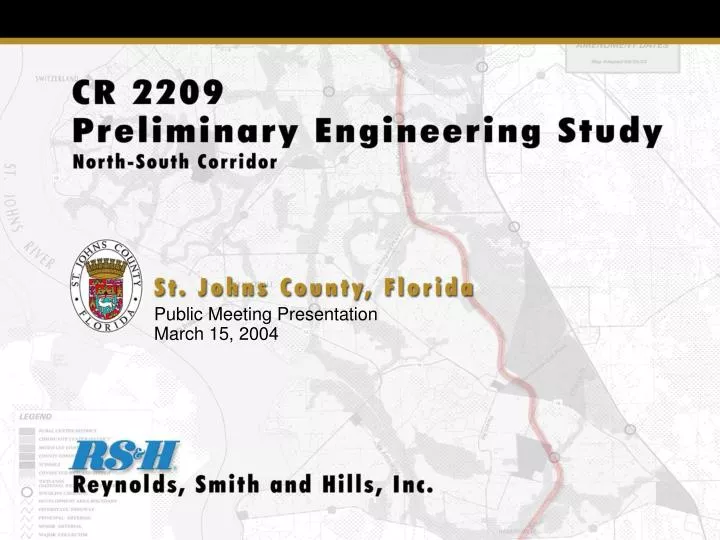
Public Meeting Presentation March 15, 2004. Project Location. Project Purpose Traffic reliever to I-95 Integrate road with the Northwest Sector Plan Connect Racetrack Road to CR 208 Study Objective Determine the location of the roadway Provide Right-of-Way Maps. Project History.

E N D
Public Meeting Presentation March 15, 2004
Project Location • Project Purpose • Traffic reliever to I-95 • Integrate road with the Northwest Sector Plan • Connect Racetrack Road to CR 208 • Study Objective • Determine the location of the roadway • Provide Right-of-Way Maps
Project History • 1995 - St. Johns County and Florida Department of Transportation “Variance Agreement” • 2001 - St. Johns County adopts a preferred location for the north/south roadway (CR 2209) as part of the “Sector Plan” • 2002 - St. Johns County adopts a “Northwest Sector Plan“ that includes the CR 2209 Corridor • 2003 - CR 2209 Preliminary Engineering Study begins • The “Variance Agreement” with the FDOT requires the CR 2209 project to meet the following deadlines: • North Segment Right of way maps by December 2005 Construction to start by December 2009 • Central Segment Right of way maps by December 2006 Construction to start by December 2010 • South Segment Right of way maps by December 2007 Construction to start by December 2015
Corridor Study Recommendations • Segment 1: LINK N2 • Provides direct connection to Racetrack Road • Supports a future connection to SR 9B • Avoids Durbin Creek crossing • Shortest segment length (3.1 miles) • Significantly fewer wetlands (22.5 acres) • Least construction cost ($8.0M) • Segment 2: LINK C2 • Borders wetland providing additional buffer and protection • Forces development and access to one side (west) of the proposed roadway • Creates additional access to International Golf Parkway • Shortest segment length (8.0 miles) • Least construction cost ($20.4M) • Segment 3: LINK S1 • Least wetland impact between S1 & S3 • No Six Mile Creek Crossing required as compared to S3 • Least construction cost ($7.8M) • Satisfies the “Variance Agreement” by connecting to CR 208
2001 Corridor Study Recommendations • General Location for the Roadway • Specific Design Items • Design Speed of 60 mph • Arterial Roadway with Intersections • Number of Lanes and Right-of-Way Width • Access Management Criteria
2001 Corridor Study Recommended Typical Sections SR 16 to CR 208 Racetrack Road to SR 16
Major Developments • Approved Since 2001 • Nocatee • Aberdeen • Durbin Crossing • Samara and Palm Lakes • Vestcor Plantation • RiverTown
North Segment Racetrack Road to Russell Sampson Road (Phase 1)
North Segment Racetrack Road to Russell Sampson Road
North Segment Russell Sampson Road to CR 210
Central Segment South Approach to CR 210 Intersection
Recommended Design Criteria • Arterial Type Roadway (Intersections/not Interchanges) • Design Speed - 60 mph • Access Management Class 3 Designation • Rural Typical Section (Minimum Right-of-Way Width of 200 Feet)
Access Management • Protect the Integrity of the Roadway System • Provide Safety to the User PURPOSE
Access Management Focus Items • Spacing of Signals • Spacing of Median Openings • Spacing of Side Road Connections • Type of Median • Type of Median Opening
Access Management Class 3 1 MILE • SPEED >45MPH • SIGNALS • FULL MEDIAN OPENINGS • CONNECTIONS 1/2 MILE 1/4 MILE CONNECTIONS CAN OCCUR EVERY 660 FEET 1 MILE • SPEED <45MPH • SIGNALS • FULL MEDIAN OPENINGS • CONNECTIONS 1/2 MILE 1/4 MILE CONNECTIONS CAN OCCUR EVERY 440 FEET
2002 Traffic Volumes (Daily) 8,600 11,900 9,700 LEGEND Daily Traffic 14,400 13,400 11,900 - Year 2002 50,500 4,700 8,100 7,000 16,900 5,200 21,900 7,600
Current Study - Year 2037 Traffic Forecasts 8,600 77,200 38,800 103,200 15,000 11,900 19,800 98,000 9,700 63,600 39,100 68,400 78,500 90,300 LEGEND Daily Traffic 14,400 86,500 13,400 41,200 11,900 - Year 2002 58,500 68,400 - Year 2025 133,000 90,300 - Year 2037 42,800 56,400 4,700 8,100 24,900 21,300 7,000 34,900 22,400 29,600 16,900 18,600 31,600 21,800 1,600 5,200 21,900 18,300 12,700 58,700
Central and South Segment Rural Typical Section – 4 Lane Requirement Rural Typical Section – 6 Lane Requirement
Tonight’s Meeting • Provide information regarding the status of the project • Secure citizen input prior to the development of alternatives within the recommended corridor PURPOSE
Project Schedule Activity Date • Public Kick-off Meeting March 15, 2004 • Alternatives Public Meeting May/June 2004 • Recommended Alternative Public Meeting January 2005 • Right-of-Way Maps June 2005 • County/FDOT I-95 (“Variance Agreement” Requirements) • North Segment (Racetrack Road to CR 210) • Right-of-Way Maps 2005 • Construction2009 • Open to Traffic2011 • Central Segment (CR 210 to SR 16) • Right-of-Way Maps 2006 • Construction2010 • Open to Traffic2012 • South Segment (SR 16 to CR 208) • Right-of-Way Maps2007 • Construction2015 • Open to Traffic2017
Public Meeting Presentation March 15, 2004