Download
1 / 21
230 likes | 422 Views
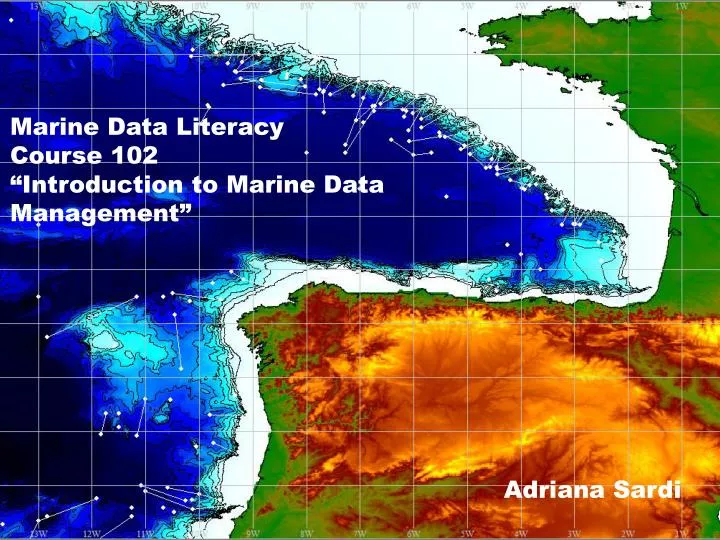
Marine Data Literacy Course 102 “Introduction to Marine Data Management”. Adriana Sardi. Exclusive Economic Zone. North coast of Spain and west coast of France Adjacent to the Portugal and UK’s EEZ. Depth contours. AOI Sediment thickness. World Ocean Database OSD data.

E N D
Marine Data Literacy Course 102 “Introduction to Marine Data Management” Adriana Sardi
Exclusive Economic Zone • North coast of Spain and west coast of France • Adjacent to the Portugal and UK’s EEZ.
Ocean Data View OSD data • More than 38612 OSD • Data since 1800 • More than 2200 cruises Data from World Ocean Database
Other ODV products1 • Selected time series • Handy to analyze the effects of known events or processes.
Other ODV products2 AOI Section
TEMPERATURE OXYGEN
Gridding the data points… 0.1 degree 0.5 degree 0.05 degree 1 degree 0.01 degree
0-5 m depth 350-400 m depth Temperature 0-5 m depth (⁰C) Temperature 350-400 m depth (⁰C)
Chlorophyll data From Global Aqua MODIS Chlorophyll_4km Data from US NASA Ocean Color Web
Sea Surface Temperature (SST) SST (⁰C) Data from US NASA Ocean Color Web
GEBCO bathymetry Data from GEBCO
… plus draw contours Data from GEBCO
Current vectors January Data from National Virtual Ocean Data System (frankly speaking data from Felipe)