Download
1 / 8
80 likes | 227 Views
Spatial data infrastructure initiatives in the Asia-Pacific region and at the global level. Peter Holland General Manager, Australia’s national mapping agency, AUSLIG Vice-President, PCGIAP Immediate Past President, GSDI steering committee peterholland@auslig.gov.au www.auslig.gov.au.

E N D
Spatial data infrastructure initiatives in the Asia-Pacific region and at the global level Peter Holland General Manager, Australia’s national mapping agency, AUSLIG Vice-President, PCGIAP Immediate Past President, GSDI steering committee peterholland@auslig.gov.au www.auslig.gov.au
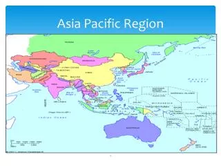
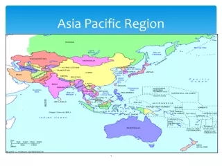
Asia Pacific Spatial Data Infrastructure (APSDI) • Network of distributed databases of standards-compliant fundamental spatial data readily accessible to address regional issues • Built by Permanent Committee on GIS Infrastructure for Asia Pacific (PCGIAP) • PCGIAP is forum for nations in Asia Pacific to consider SDI issues • www.permcom.apgis.gov.au • 6th PCGIAP and 15th UNRCC meetings Kuala Lumpur April 2000
PCGIAP working groups • Geodesy • Defining a horizontal and vertical datum for the region • Regional observation campaigns, 17 countries • Workshops, develop transformation parameters • Regional fundamental data • Policy on sharing data • Pilot administrative boundary dataset • Pilot data node network • GIS application demonstrations
PCGIAP working groups • Development needs taskforce • Publication number 1 defining APSDI • Questionnaires and workshops to determine needs • Communication and outreach • Website, publications, papers • PCGIAP structure in period 2000-2003 • Geodesy and regional fundamental data • Cadastral and institutional strengthening
Global Spatial Data Infrastructure (GSDI) • Encompasses policy, organisational, technical and financial arrangements to support global access to GI • Critical to the attainment sustainable development • GSDI Steering Committee comprising cross section of stakeholder community • www.gsdi.org
Working groups • Operations Working Group • oversee implementation of umbrella organisation structure. • Technical Working Group • forum for the discussion and coordination of technical activities. Eg SDI Cookbook. • Outreach and Capacity Building WG • raise national awareness of SDI issues. • Legal and Economic Working Group • discuss issues affecting use of geographic data Eg liability, intellectual property
Other activities • Business case • scoping study completed • focus on case studies • Links to related initiatives • digital earth (international steering committee), global mapping (ISCGM) and UN geographic database project • 5th GSDI conference • Cartagena Colombia, 21-25 May 2001 • in conjunction with inaugural PC for Americas
Spatial data infrastructure initiatives in the Asia-Pacific region and at the global level Peter Holland General Manager, Australia’s national mapping agency, AUSLIG Vice-President, PCGIAP Immediate Past President, GSDI steering committee peterholland@auslig.gov.au www.auslig.gov.au