Download

1 / 25
250 likes | 416 Views
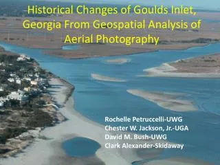
Historical Changes of Goulds Inlet, Georgia From Geospatial Analysis of Aerial Photography. Rochelle Petruccelli-UWG Chester W. Jackson, Jr.-UGA David M. Bush-UWG Clark Alexander-Skidaway. Savannah. Goulds Inlet. Sea Island. Goulds Inlet Between St. Simons and Sea Islands, Georgia

E N D
Historical Changes of Goulds Inlet, Georgia From Geospatial Analysis of Aerial Photography Rochelle Petruccelli-UWG Chester W. Jackson, Jr.-UGA David M. Bush-UWG Clark Alexander-Skidaway
Savannah Goulds Inlet
Sea Island • Goulds Inlet • Between St. Simons and Sea Islands, Georgia • Mesotidal, spring tide range • is 3.1 meters • Small, stable inlet
Sea Island spit seawall Johnson rocks
A B C D
Previous Work • Griffin, Martha M., and Henry, Vernon J. 1984, Historical Changes in the Mean High Water Shoreline of Georgia, 1857-1982.
1924-1974 1857/60 - 1974 Griffin and Henry: Changes to St. Simons and Sea Island
Goals • Assess the coastal hazards vulnerability of homes along East Beach, St. Simons Island, GA • GIS evaluation of historical behavior of Goulds Inlet • Shoreline positions • Inlet channel positions • Inlet-associated shoals • Predict future behavior of inlet system • Recommend management options
Methods • Acquire historical information • Air photos • T-sheets • DOQQs • Digitize • Inlet channel • Historical shorelines • Inlet shoals • Analyze position data • Shorelines • Inlet 1963
Goulds Inlet, Georgia 1942 1964 1979 1984 1993
Inlet channel has migrated over time Current tidal channel location Sea Island spit seawall Previous tidal channel location(~late1800s)
Shoreline Change Statistics • EPR = End Point Rate—Distance between oldest and youngest shorelines divided by total time elapsed (m/yr) • AOR = Average of Rates—average of separate EPRs for all combinations of shorelines when more than two are available • LRR = Linear Regression Rate—slope of the best-fit line using all data points • JKR = Jackknife Rate—average of slopes of all points, leaving out one point each iteration • AOE = Average of Eras—change rates are calculated between each set of air photos, then averaged
1869-1933 Era 1933-1957 Era East Beach, St. Simons Island 1957-1979 Era 1979-1993 Era End Point Rates for selected eras 1993-1999 Era Accretion Erosion
Shoreline Change Summary 76 transects 22 show erosion 54 show accretion 1869-2003 Era accretion erosion
Inlet Shoals 1963
Persistence of Inlet Shoals Green and yellow = frequent shoaling Blue = infrequent shoaling
St. Simons Island Sea Island St. Simons Island Sea Island St. Simons Island Sea Island
Results • Sea Island spit has steadily accreted • Northern tip of St. Simon’s has experienced long-term erosion • St. Simons East Beach has experienced net long-term accretion • Goulds Inlet appears relatively stable, though it does exhibit slow southerly migration
Recommendations for homes along East Beach, St. Simons Island, GA • Major Engineering • Remove seawall, relocate inlet channel • Reorient inlet channel by dredging • Augment existing rocks, add sand, vegetate • Minor Engineering • Retreat /relocation • Retrofit buildings • Do nothing (preferred alternative)
Acknowledgements • Mike Robinson, Skidaway Institute of Oceanography • Clark Alexander, Skidaway Institute of Oceanography • John Gay, St. Simons Island • John Congleton, UWG Geosciences • Jeong Seong, UWG Geosciences • Georgia Department of Transportation • University of West Georgia • Georgia Sea Grant College Program