Download
1 / 20
200 likes | 290 Views
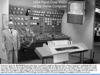
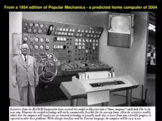
From a 1954 edition of Popular Mechanics - a predicted home computer of 2004. Connecting the Components. Integrated base data – The National Map Coordination, standards, policy – Federal Geographic Data Committee Discovery and access – Geospatial One-Stop

E N D
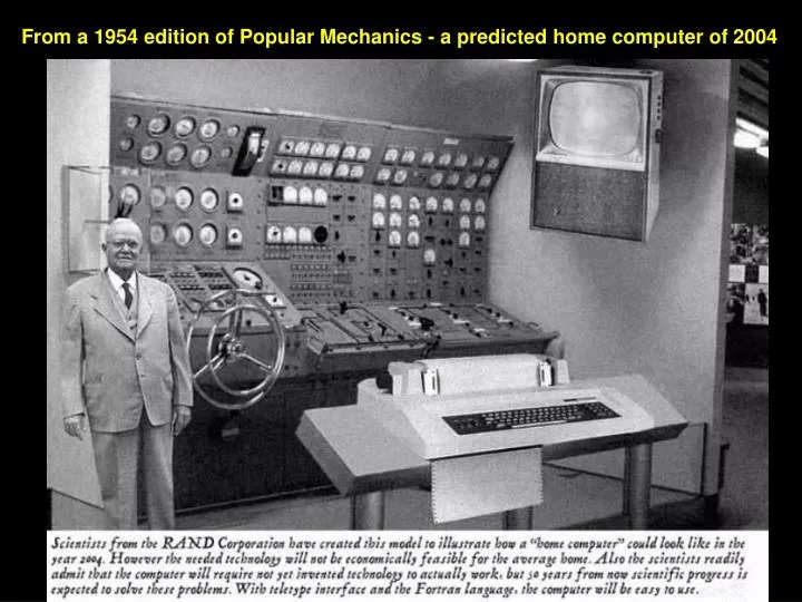
From a 1954 edition of Popular Mechanics - a predicted home computer of 2004
Connecting the Components • Integrated base data – The National Map • Coordination, standards, policy – Federal Geographic Data Committee • Discovery and access – Geospatial One-Stop • Optimize use of geospatial technologies– Enterprise Geospatial Information Management Coordination& Standards Consistent & Current Content Data Discovery & Access How are they different?
A Bold Step . . . Strategic Alignment of USGS Programs • Charge from USGS Director, August 2004 • Strategic Alignment of Activities • National leadership of highly visible, high-demand geospatial programs • Time to bring it all together!
NGPO Directions • Unify and simplify • Act as one, under one executive (Karen Siderelis, GIO) • Contribute to completion of the NSDI • Include partners in all aspects • Be unconstrained by today or yesterday – “how we look today is not how we will look tomorrow” • Bias toward action “transformation”
NGPO Core Team • Govern the process • Sponsor Study Teams • Prepare Final Plan and Report for USGS Director • “Pillars” • Ivan DeLoatch, Federal Geographic Data Committee • Mark DeMulder, Geospatial One Stop • Hank Garie, Cooperative Topographic Mapping Program • Bob Pierce, Interior Enterprise Geographic Information Management • Stan Ponce, Partnerships and External Coordination • Mark Naftzger, Emergency Operations
NGPO Study Teams • Unified Geospatial Enterprise Architecture • Geospatial Technology Integration • Partnership Offices • Unified NSDI Web Presence • Measuring Geospatial Investments • USGS Geospatial Products and Services
NGPO Purpose “Providing leadership to place reliable geographic information at the fingertips of the Nation.” http://www.usgs.gov/ngpo
Geo-spatial Framework for Surface Water Vision NHD Follow a drop of water from where it falls on the land, to the stream, and all the way to the ocean. NED EDNA How will this vision be attained? WBD
Geo-spatial Framework for Surface Water Sponsor: Subcommittee for Spatial Water Data • Federal Geographic Data Committee (FGDC) • Advisory Committee for Water Information (ACWI), Subcommittee for Spatial Water Data Information (SSWD)
The NationalWatershed Boundary Dataset (WBD) Kenny Legleiter, Michael Laitta & Karen Hanson WBD Technical Team
Geo-spatial Framework for Surface Water Watershed Boundary Dataset • Non-politically biased • Hydrologically sound • consisting of Common reporting units • Detailed Provide national standard framework of hydrologic units that are: National addressing system
Geo-spatial Framework for Surface Water Partners NWS (EDNA stage 1) NRCS (review, website, Hydro tools) Tools Standards Coordination Pilots USFS ($6M hi-res NHD, WBD) Subcommittee on spatial water data USEPA (NHD,EDNA tools, Flow & velocity work) NOAA (coastal watersheds) Data Stewardship State Partners (hi-res NHD, EDNA stage 2) USGS (Streamstats)
Subcommittee for Spatial Water Data Proposed WBD Work Groups/Teams: • Technical team • Management team • Program plan • Set priorities • $$ NEW!
New York NRCS IRT NRCS NYESF New York Watershed Boundary Commitments Challenge NYDEC NRCS/Titan EPA R3 NRCS NYESF Challenge