Download
1 / 1
30 likes | 127 Views
Model What is CE-QUAL-W2? Two-dimensional Laterally averaged Hydrodynamic and water quality. Figure 1. El Cajon Dam Location. Obtain background information Find geographic coordinates of the site Define the reservoir extent. Results. Figure 2. Reservoir TIN.

E N D
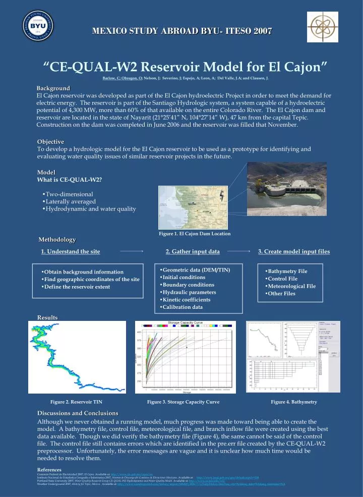
Model • What is CE-QUAL-W2? • Two-dimensional • Laterally averaged • Hydrodynamic and water quality Figure 1. El Cajon Dam Location • Obtain background information • Find geographic coordinates of the site • Define the reservoir extent Results Figure 2. Reservoir TIN Figure 3. Storage Capacity Curve Figure 4. Bathymetry MEXICO STUDY ABROAD BYU- ITESO 2007 “CE-QUAL-W2 Reservoir Model for El Cajon” Barlow, C; Obregon, O; Nelson, J; Severino, J; Espejo, A; Leon, A; Del Valle, J.A; and Clausen, J. Background El Cajon reservoir was developed as part of the El Cajon hydroelectric Project in order to meet the demand for electric energy. The reservoir is part of the Santiago Hydrologic system, a system capable of a hydroelectric potential of 4,300 MW, more than 60% of that available on the entire Colorado River. The El Cajon dam and reservoir are located in the state of Nayarit (21°25’41” N, 104°27’14” W), 47 km from the capital Tepic. Construction on the dam was completed in June 2006 and the reservoir was filled that November. Objective To develop a hydrologic model for the El Cajon reservoir to be used as a prototype for identifying and evaluating water quality issues of similar reservoir projects in the future. Methodology 1. Understand the site 2. Gather input data 3. Create model input files • Geometric data (DEM/TIN) • Initial conditions • Boundary conditions • Hydraulic parameters • Kinetic coefficients • Calibration data • Bathymetry File • Control File • Meteorological File • Other Files Discussions and Conclusions Although we never obtained a running model, much progress was made toward being able to create the model. A bathymetry file, control file, meteorological file, and branch inflow file were created using the best data available. Though we did verify the bathymetry file (Figure 4), the same cannot be said of the control file. The control file still contains errors which are identified in the pre.err file created by the CE-QUAL-W2 preprocessor. Unfortunately, the error messages are vague and it is unclear how much time would be needed to resolve them. References Comisión Federal de Electricidad 2007, El Cajon. Available at: http://www.cfe.gob.mx/cajon/en Instituto Nacional de Estadística Geografía e Informática 2007, Sistema de Descarga del Continuo de Elevaciones Mexicano. Available at: http://www.inegi.gob.mx/geo/default.aspx?c=338 Portland State University 2007, Water Quality Research Group CE-QUAL-W2 Hydrodynamic and Water Quality Model. Available at: http://www.ce.pdx.edu/w2/ Weather Underground 2007, History for Tepic, Mexico. Available at: http://www.wunderground.com/history/airport/MMEP/2006/7/1/DailyHistory.html?req_city=NA&req_state=NA&req_statename=NA