Download
1 / 1
10 likes | 14 Views
This study utilizes Doppler Radar rainfall estimates and weather stations to predict the risk of Wheat Scab in the Spring Creek Watershed. It also examines the role of wind trajectories in the migration of gypsy moths.

E N D
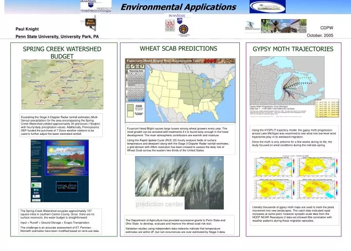
Environmental Applications CDPW October, 2005 Paul Knight Penn State University, University Park, PA WHEAT SCAB PREDICTIONS SPRING CREEK WATERSHED BUDGET GYPSY MOTH TRAJECTORIES Excerpting the Stage 3-Doppler Radar rainfall estimates (Multi-Sensor precipitation) for the area encompassing the Spring Creek Watershed yielded approximately 30 grid boxes (16sqkm) with hourly/daily precipitation values. Additionally, Pennsylvania DEP funded the purchase of 7 Davis weather stations to be used to further adjust the basin estimated rainfall. Fusarium Head Blight causes large losses among wheat growers every year. The mold growth can be arrested with treatments if it is found early enough in the head development. The main atmospheric contributors are warmth and moisture. Using the Rapid Update Cycle (RUC 20) hourly analysis fields of surface temperature and dewpoint along with the Stage 3-Doppler Radar rainfall estimates, a grid domain with 20km resolution has been created to assess the daily risk of Wheat Scab across the eastern two-thirds of the United States. Using the HYSPLIT trajectory model, the gypsy moth progression across Lake Michigan was examined to see what role low-level wind trajectories play in its westward migration. Since the moth is only airborne for a few weeks during its life, the study focused on wind conditions during the mid-late spring. Literally thousands of gypsy moth traps are used to track the pests movement into new landscapes. The catch data indicated rapid increases at some point, however synoptic scale data from the NCEP-NCAR Reanalysis 2 data set showed little correlation with weather patterns during these migration episodes. The Spring Creek Watershed occupies approximately 157 square miles in southern Centre County. Since there are no surface reservoirs, the water budget is straightforward: Input = Runoff + Ground Storage + Evapo-Transpiration. The challenge is an accurate assessment of ET. Penman-Monteith estimates have been modified based on land-use data. The Department of Agriculture has provided successive grants to Penn State and Ohio State to develop, evaluate and improve the wheat scab risk tool. Validation studies using independent data networks indicate that temperature estimates are within 2F, but rain occurrences are over-estimated by Stage 3 data.