Download
1 / 31
310 likes | 480 Views
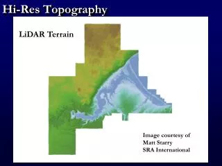
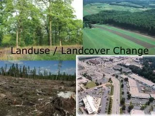
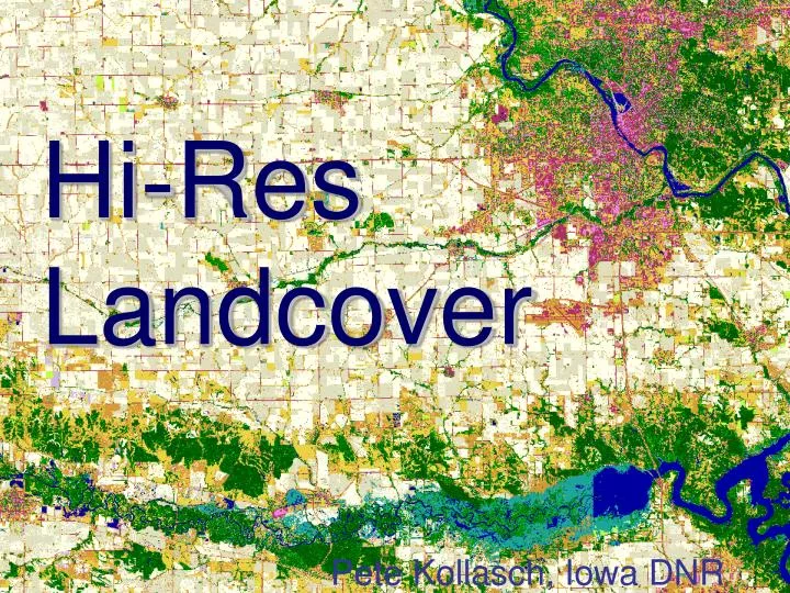
Hi-Res Landcover. Pete Kollasch, Iowa DNR. You are here. It’s about resolution. HRLC 1m. It’s about resolution. 2002 15m. It’s about resolution. 2009 2m. It’s about resolution. 2002 15m. What is it?. Statewide Land Cover file 1 meter spatial resolution

E N D
Hi-Res Landcover Pete Kollasch, Iowa DNR
It’s about resolution HRLC 1m
It’s about resolution 2002 15m
It’s about resolution 2009 2m
It’s about resolution 2002 15m
What is it? • Statewide Land Cover file • 1 meter spatial resolution • Compare to previous 15m 1986, 1990, 2002 • Derived from aerial imagery and lidar data • Previous all derived from Landsat imagery • Interpreted to Summer 2009 NAIP • County files ~ 50% complete now • 100% complete by end of 2013
Need • 2002 – most recent landcover product • More current data desired • In May 2003 – Landsat 7 partial failure • With only Landsat 5: difficult to obtain sufficient satellite imagery coverage • Interest in higher resolution product
Opportunity • Annual NAIP imagery available • From 2004 through 2011 • 4 band spring leaf-off imagery available • 2007 Northwest by Sanborn • 2009 West & 2010 East by ASI • Lidar elevation data becoming available
Criteria for Process • Reliable enough to produce compatible products from a wide range of input quality • That can be completed in a finite period
Issues • Aerial Photography has high spectral variability • Collection date (esp. NAIP) • Multiple cameras / collections • Internal variability – hotspots, etc. • Suggests the use of “flattening” technologies • Need sufficient spectral content
Technologies • Multitemporal • Lidar Normalized Elevation • Common Land Units • Segmentation • Knowledge-based classification • Classification & Regression Tree
Technologies • Multitemporal • Lidar Normalized Elevation • Common Land Units X • Segmentation X • Knowledge-based classification X • Classification & Regression Tree X • Independent Component Analysis • Classical Unsupervised
HRLC History • Initial research began in 2002 • Initial results were not very successful • Meetings: DNR, UI, ISU, UNI late 2008 • Procedure design 2009 • Began receiving enough data in late 2009 • 2010 to present • Preprocessing, Interpretation, Postprocessing • Final results began emerging early 2012
Inputs • Multitemporal Aerial Imagery • 2007/2009/2010 Four band spring imagery • 2009 NAIP imagery • 2008 NAIP imagery • LiDAR normalized elevation layer • First return minus Bare earth
Inputs • Multitemporal Aerial Imagery • 2007/2009/2010 Four band spring imagery • 2009 NAIP imagery • 2008 NAIP imagery • LiDAR normalized elevation layer • First return minus Bare earth • What issues do they solve?
Preprocessing • Aerial Imagery Stack • 10 bands (4 + 3 + 3) • Areas of consistent spectral character • ICA (primary flattening technology) • Add lidar normalized elevation band • Unsupervised / Supervised Classification • 250 clusters
Interpretation • ERDAS Class Grouping Tool • Initially 2 tier • Grouping / Checking • Later 3 tier • Grouping / Checking / Final Check • Final check by a single interpreter for consistency
Postprocessing • Fuzzy Recode (another flattener) • Erode edges of tiles, sequence • Mosaic tiles together • Lidar normalized elevation filtering • Shadow conversion around structures • Eliminate objects < 10 pixels • Reconstruct entire mosaic
Counties • Clip county to rectangle with 100m buffer • If there be holes, wait for enough data to fill • Raster edit steps • General rule: if not possible, change it • Affects only a small percent of space, but makes a big difference in the look • 2 sets of eyes • Prep for NRGIS library • (4 bit, color table, names, round to .5 m)
HRLC Data Access • NRGIS library, by FTP • By county: HRLC_2009_xx.img • http://www.igsb.uiowa.edu/nrgislibx/ • Map Service available
Thejashwini Ramarao Matt Swanson Kathryne Clark Matt Gosse Sarah Porter Cody Hackney ISU, UI, UNI remote sensing personnel Jim Giglierano Chris Ensminger Daryl Howell Casey Kohrt Chris Kahle and many more … Thanks
Questions? • Pete Kollasch • Pete.kollasch@dnr.iowa.gov • 319-335-1578