Download
1 / 32
320 likes | 424 Views
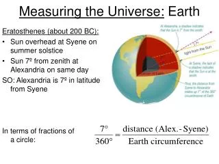
Chapter 8: Measuring sealevel. Sea Level and Pressure. Pressure and sea level measurements are of special interest in geophysical studies, and few other records are “as continuous or span such long timescales” But relation between pressure and sealevel is not trivial. Really we want.

E N D
Sea Level and Pressure Pressure and sea level measurements are of special interest in geophysical studies, and few other records are “as continuous or span such long timescales” But relation between pressure and sealevel is not trivial. Really we want Thus the quantity of dynamical interest is pressure on a geoidal surface just beneath the sea surface. This is called SYNTHETIC SUBSURFACE PRESSURE (SSP) The height equivalent of SSP is called ADJUSTED SEA LEVEL (ASL)
Sea Level and Bottom Pressure • Bottom pressure observations have been made with increasing frequency over the past decades availability of stable pressure sensors • They measure absolute pressure directly, but • - including atmospheric component (different from sealevel measurement) • - Including pressure changes due to density fluctuations of the water column above the sensor (important if DEEP sensor, negligible if shallow) • So: • To compare BP measurements to SSP measured from coastal level stations, need to convert BP also to SSP.
Sea Level and Bottom Pressure Assume hydrostatic pressure distribution in the vertical integrating over the water column Baroclinic Pressure SSP ( is sea surface height) Approximated here as since is small Density is a function of Temperature: with So SSP determined from bottom pressure is
Tide gauge Device to measure sea level Mean Sea Level (‘still water level’) Level of the sea with motions such as wind waves and tides, averaged out. >> Measured wrt land so changes can result - from a real change in sea level - from a change in height of the land on which the tide gauge operates
Tide Gauges • Stilling well and float • Pressure systems • Acoustic systems • Radar systems
Tide gauge • Kelvin type tide gauge: • Used pencils and springs • Had to wind springs daily • Paper set vertically • (prone to damping and strecthing as it had no cover)
Tide gauge • Some factors that complicate determining the sea level change from tide gauge data: • Settling of the site • Vertical motions of the region due to post-glacial rebound, tectonic uplift or crustal subsidence In long term assessments of sea level change, variables such as barometric pressure and windspeed have to be monitored so they can be eliminated.
Stilling Well National Tidal and Sea Level Facility UK Tide Gauge Network (Ilfracombe)
Pressure Systems • Need knowledge of seawater properties • Two main types: • Pneumatic bubbler gauges • Pressure sensor gauges
Pressure Sensor Gauges • Installed directly in the sea to measure sub-surface pressure • Absolute pressure (sea level and atmosphere), which requires a separate barometer synchronized with sensor to correct for atmosphere • Differential pressure transducers, which have a vented cable that is exposed to the atmosphere (but they are known to have blockage issues)
Installation considerations • Withstanding ice, winter storms • Stable ground (no erosion, land subsidence, etc.) • Areas of representative tides (not headlands) • Not over sandbars/long sloping beaches with unusual wave patterns • Not near breakwaters, construction, shipping traffic, outfalls, estuaries • Need nearby benchmarks for leveling
Comparison • Acoustic sensors • In sounding well - $8-12,000, <1 cm accuracy • Open air - $5-8,000, >1 cm accuracy • Pressure • Single transducer - $5-12,000, ~mm precision • Multiple transducers - $12-20,000, ~mm precision & accuracy • Bubble gauge - $8-12,000, ~1 cm accuracy (3) Stilling Well - Float gauges - $5-12,000, ~1 cm accuracy (4) Radar Systems - radar gauge - $12-20,000, expected ~1 cm accuracy
IOC Recommendations • Mid/low latitude • Acoustic gauge with sounding tube • Radar tide gauge • Multiple transducer pressure system • High latitude • Absolute pressure sensor & barometer • Bubbler pressure gauge
GLOSS Establishing high quality global and regional sea level networks for application to climate, oceanographic and coastal sea level research. Global core network: 290 sea level stations around the world http://www.gloss-sealevel.org/
http://www.gloss-sealevel.org/network_status/ http://www.psmsl.org/data http://www.psmsl.org/data/obtaining/
University of Hawaii Sea Level Center To collect, process, distribute, and analyze in-situ tide gauge data from around the world in support of climate research. http://uhslc.soest.hawaii.edu/ data
Accuracy of tide gauge and bottom pressure measurements • Associated to a variety of errors • Inaccuracies in the measurement • Local peculiarities of the observational site In the case of bottom pressure sensors: Possible vertical motions of the anchoring system: anchor drifts (real or by sinking). • Harms and Winant (1994) Synthetic Subsurface Pressure Derived from Bottom Pressure and Tide Gauge Observations. Journal of Atmospheric and Oceanic Technology. • Lentz (1993) The Accuracy of Tide-Gauge Measurements at Subtidal Frequencies. Journal of Atmospheric and Oceanic Technology. • Wearn and Larson (1982) Measurements of the sensitivities and drift of Digiquartz pressure sensors. Deep-Sea Research.
Pressure Sensors See chapter 6
η 0 isopycnal -H Travel time anomaly Δtt is For Gulf Stream front, first term is about 1ms and second one 7ms, EACH WAY, so total signal approx. 16ms roundtrip
Inverted echosounder: empirical traveltime vs dynamic height relations
TOPEX/Poseidon & Jason satellites -radar altimeter emitting 2 frequencies (range) -microwave radiometer measuring at 3 frequencies for water vapor content -DORIS, LRA, and GPS for precise orbital information