Download
1 / 19
190 likes | 352 Views
Integration of the four Basic SGI Principles. Geomorphology, Stratigraphy, Soil Morphology and Hydrology Our theories of today solve our problems of today. Jacob Bronowski Language is not describing facts, but creating images. Niels Bohr. 6/1/2012. Course Objectives (1).

E N D
Integration of the four Basic SGI Principles Geomorphology, Stratigraphy, Soil Morphology and Hydrology Our theories of today solve our problems of today. Jacob Bronowski Language is not describing facts, but creating images. Niels Bohr 6/1/2012
Course Objectives (1) Apply the 4 principles to the different geomorphic environments for soil survey data development, evaluation and delivery. • Soil geomorphology • Stratigraphy • Hydrology, and • Pedology
Course Objectives (2) • Use the interrelationships of ecological site factors to soil geomorphology in preparation of soil survey data • Identify soil patterns as controlled by soil landscape hydrology and their relations to water quality and hydric soils. • Discuss spatial distribution and the age, both relative and absolute, of geomorphic surfaces and their relationships to landforms, soil processes, soil patterns, and ecological influences in order to produce high quality soils data.
Course Objectives (3) • Identify types of earth materials, sediment bodies, and stratigraphic relationshipsas they relate to soil genesis for the development of high quality soils data. • Create 2D diagrams and 3D landscape models to illustrate key processes occurring in any geomorphic environment using tacit knowledge and/or field gathered documentation. • Use the Geomorphic Description System (GDS) properly in gathering and documenting point data.
Participants will be tested as follows: 70% or 105/150 is satisfactory
This training integrates four principles -- geomorphology, stratigraphy, hydrology, and pedology to understand soil landscapes.
Participants will apply these principles to topo-sequences,hydro-sequences, and soil associations to produce conceptual, visual models for their MLRA. Such models improve soil interpretation and communicate soil knowledge to clients and fellow workers.
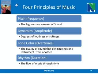
Four Principles The Cadre’s Mantra • GEOMORPHOLOGY Geo = Earth (land) Morph = Form Ology = study • STRATIGRAPHYStrata=materials (layers) Graph = structure • HYDROLOGYHydro = water Ology = study • SOIL MORPHOLOGYField Observations and Interpretations of soil
PEDIMENTS (Erosional Footslopes) DYNAMIC EQUILIBRIUM BACK-WEARING Cross-Section 5
Valley & Ridge MLRA 147 B C D F Toe Foot Back slope Sandstone Quartzite Sandstone Shale Limestone
Precip On ContourCross-Section“Red Edge in Coastal Plains” A B C soil aquifer Iron Precip. Aquitard shale
TOPOGRAPHIC MAPAlice, Cass Co., ND • Contour lines • Lack of streams • Trees? 12
CONSIDER A CROSS-SECTION VIEW VERSUS MAP VIEW! WHAT WOULD SEE OF THIS SOIL PEDON FROM AN AIRCRAFT OR BY SIMPLY WALKING THE GROUND? We need to look IN the ground to get the depth dimension. CROSS-SECTION DEVELOPMENT IS AN ESSENTIAL PART OF SOIL GEOMORPHOLOGY. SURFICIAL VIEWING IS NOT ENOUGH FOR UNDERSTANDING THE SOIL. IF ONE CANNOT DRAW THE CROSS-SECTION, ONE DOES NOT UNDERSTAND THE LANDSCAPE.
OUTWASH TERRACE; HIGH WATER TABLE EVERY SPRING; 94% SAND OR COARSER, HIGH SODIUM & pH; white Bk is Protodolomite; note the Btn horizon. E Btn pH 9.1 Bk 50% clay 2Cg 94% sand THE PARTICIPANT WILL DESCRIBE AND EXPLAIN THE DEVELOPMENT OF THIS SOIL, ESPECIALLY FOCUS ON THE WATER DYNAMICS. STIRUM: COARSE-LOAMY, MIXED, SUPERACTIVE, FRIGID TYPICNATRAQUOLL
Concepts to use in your answer • Matric Flow a) wet to dry; b) frost; • Saturated flow above and below water table; • Formation of a Bt, Btn and Bk in terms of hydrology; • Dispersion; translocation, reverse translocation • Braided stream; terrace • Evaporite sequence – alkaline branch • Redoximorphic features
Other Concepts in the Class • Osmotic flow; Reflow • Most Important Line; • Multiple Working Hypotheses; • Phreatophyte; • Meandering Stream; • Recharge, Flowthrough, Discharge • Arid, Semi-arid, Sub-humid, Humid, • Mass-wastage • Erosivity, Erodibility • Saltation, Suspension, Traction • Hjulstrom’s diagram
Other Concepts in the Class • Back-wearing, Super-position, Cross-cutting, Rule of Ascending Slopes • Geomorphic Surfaces • Faceted (stepped) Surfaces • Cohesion and Internal Friction All these concepts looks like a bigger task than it is. We will be using these in the class and field. You will be using these with other participants. We will be immersed in the integration of the parts into one whole.
EPILOG • I have tried to use “PARTICIPANTS” as an inclusive term, which includes all of us. • We will work hard; WE will have fun; and WE will learn from each other. mudman@gotsky.com