Download
1 / 10
100 likes | 224 Views
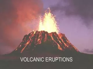
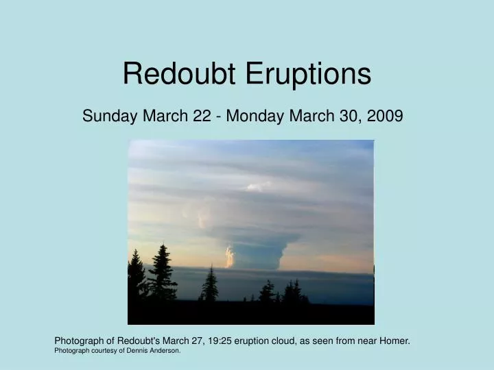
Redoubt Eruptions. Sunday March 22 - Monday March 30, 2009. Photograph of Redoubt's March 27, 19:25 eruption cloud, as seen from near Homer. Photograph courtesy of Dennis Anderson. Sunday March 22 nd. 10:38 pm AKDT. Tops 20,000 feet. 11:56 pm AKDT. Tops to 50,000 feet. Monday March 23 rd.

E N D
Redoubt Eruptions Sunday March 22 - Monday March 30, 2009 Photograph of Redoubt's March 27, 19:25 eruption cloud, as seen from near Homer. Photograph courtesy of Dennis Anderson.
Sunday March 22nd • 10:38 pm AKDT. Tops 20,000 feet. • 11:56 pm AKDT. Tops to 50,000 feet.
Monday March 23rd • Two small eruptions. • 4:37 am AKDT. Tops to 60,000 feet. • 7:41 pm AKDT. Tops 50,000 to 60,000 feet. Image of ashfall, taken from Tordrillo Mountain Lodge on Judd Lake (just north of Beluga Lake, at the head of the Talachulitna River.) Photograph courtesy of Lel Tone.
Thursday March 26th • 8:38 am AKDT. Tops unkn. • 9:24 am AKDT. Tops to at least 65,000 feet. Measurement of the shadow indicate approximately 73,000 • Series began at 11:47 pm AKDT. Tops 30,000 to 50,000 feet. Lasted into early morning March 27th. • Eruption produced a lahar down the Drift River. Mudflows are occurring in the Drift River Valley and pyroclastic flows were observed by the AVO web cameras.
Friday March 27th • 8:40 am AKDT. Tops to 50,000 feet. • 5:35 pm AKDT. Tops to 40,000 feet. • 7:25 pm AKDT. Tops to 51,000 feet. • 1120 pm AKDT. Tops to 40,000 feet. Photograph of lightning from Redoubt's 11:20 pm, March 27, eruption, courtesy of Bretwood Higman.
Saturday March 28th • 120 am AKDT. Tops to 50,000 feet. • 140 pm AKDT. Tops 25,000 to 30,000 feet. • 329 pm AKDT. Tops to 35,000 feet. • 723 pm AKDT. Tops to 45,000 feet. • Ashfall N. Kenai Peninsula, Anchorage, Mat-Su Valley to Valdez. • Anchorage International closed due to ashfall. Photograph of Redoubt's ash cloud, viewed while traveling between Kenai and Nikiski. Photograph courtesy of Jaden Larson.
Sunday March 29th • 1120 am AKDT. Steam emission to 25,000 feet. Seismicity decreased within 15 minutes. • 1114 pm AKDT. Ash cloud tops to 20,000 feet.
Monday March 30th • 944 am AKDT. Ash cloud tops to 27,000 feet. • 1126 pm AKDT. Ash cloud tops to 25,000 feet. • Since the event began. Estimated 250 canceled flights. Over 10,000 impacted passengers. Cargo flights diverted to Oakland, Seattle, Vancouver. FedEx and UPS cutting staff (laying off support staff).
Tuesday March 31st • 407 pm AKDT. Tops 25,000 feet. • AK Airlines canceled all flights again.