Download
1 / 21
0 likes | 3 Views
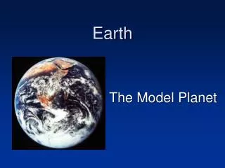
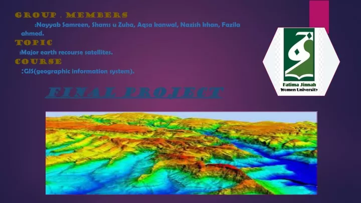
A major Earth resource satellite is a sophisticated spacecraft equipped with advanced sensors to monitor and gather data on various Earth resources. It provides valuable information about land use, vegetation health, water resources, climate patterns, and environmental changes, aiding in scientific research, resource management, and decision-making processes.<br>in this slides information of most important satellites are present

E N D
GROUP . MEMBERS :Nayyab Samreen, Shams u Zuha, Aqsa kanwal, Nazish khan, Fazila ahmed. TOPIC :Major earth recourse satellites. COURSE :GIS(geographic information system). Final project
Major earth resource satellites • Earth resource satellites, also known as Earth observation satellites or remote sensing satellites, are specifically designed to gather data and images of the Earth's surface, atmosphere, and oceans. These satellites play a crucial role in monitoring and understanding various natural and human-induced processes on our planet. • Here are some key points about Earth resource satellites: • . Data Collection and Imaging • Monitoring Land and Vegetation • Ocean and Coastal Monitoring • Atmospheric Monitoring • Disaster Management • Scientific Research and Environmental Monitoring • Satellite sensor system: • Satellite sensor systems are integral components of Earth observation satellites. • They consist of various instruments and sensors designed to collect data about the Earth's surface, atmosphere, and other environmental parameters from space. • These systems play a crucial role in monitoring weather patterns, climate change, natural disasters, and other phenomena.
•Landsat is a satellite sensor system. The Landsat program consists of a series of Earth-observing satellites that have been capturing images of the Earth's surface since 1972. Satellite sensor program (Landsat): The Landsat program is a long-running series of Earth observation satellites developed and operated by NASA and the United States Geological Survey (USGS). 1. Initiation: in 1972 with the launch of the first Landsat satellite, Landsat 1 (originally called Earth Resources Technology Satellite-1 or ERTS-1). 2. Earth Observation: is to collect high-quality, multispectral imagery of the Earth's surface to monitor and understand changes over time. 3. Continuous Data Collection: making it the longest-running program of its kind. Currently, Landsat 8 and Landsat 9 are the active satellites in the program. 4. Multispectral Imaging: uses sensors to capture images in multiple spectral bands, including visible, near-infrared, and thermal infrared. This enables detailed analysis of land cover, vegetation health, and other surface properties. 5. Global Coverage: The Landsat satellites, provide global coverage of the entire planet's landmass every 16 days.
Timeline of the Landsat Program, beginning with the launch of Landsat 1 in 1972. Landsat Next, which is expected to launch in late 2030, will continue the legacy of the Landsat Program. Note: Landsat 7, 8, and 9 are actively collecting data. However, on May 5, 2022, Landsat 7 began an extended science mission at a lower orbit.
6. Data Accessibility: Landsat data is freely available to the public, making it a valuable resource for scientists, researchers, policymakers, and the general public. • 7. Land Cover Change: Landsat imagery is instrumental in monitoring and documenting changes in land cover, including deforestation, urbanization, agricultural practices, and natural disasters. • 8. Environmental Monitoring: The Landsat program contributes to environmental monitoring efforts by providing data on water resources, coastal zones, wetlands, and biodiversity. • 9. Historical Archive: The Landsat program has created an extensive archive of satellite imagery, allowing researchers to compare past and present conditions and understand long-term trends. • 10. Applications: Landsat data is used in a wide range of applications, including agriculture, forestry, urban planning, climate studies, disaster management, and resource exploration. • The Landsat program has been instrumental in advancing our understanding of Earth's dynamic processes and supporting sustainable resource management practices. • History
The Landsat program was started in response to growing recognition of the need for systematic and comprehensive monitoring of Earth's resources from space. The first satellite, Landsat 1 (originally called Earth Resources Technology Satellite-1 or ERTS-1), was launched on July 23, 1972. • Over the years, the Landsat program expanded with the launch of subsequent satellites. Landsat 2 was launched in 1975, followed by Landsat 3 in 1978. These satellites improved upon the capabilities of their predecessors, enhancing the quality and resolution of the collected imagery. • Landsat 4 and 5:The Landsat program, initiated in 1972, is a long-standing Earth observation program developed and operated by NASA and the United States Geological Survey (USGS). • Landsat 4 was launched in 1982, and Landsat 5 in 1984. These satellites introduced significant technological advancements, including increased spectral bands, thermal infrared sensors, and improved data transmission capabilities. • In 1985, the management of Landsat satellites was transferred to the private sector, marking the first time a civilian Earth observation satellite program was operated by a commercial entity. This transition aimed to reduce costs and increase operational efficiency. • Landsat 6 and 7: Landsat 6, launched in 1993, failed to reach orbit. However, Landsat 7, launched in 1999, successfully continued the data collection mission. It introduced the Enhanced Thematic Mapper Plus (ETM+) sensor, providing improved spectral and radiometric capabilities. • Landsat 8 and Beyond: Landsat 8, launched in 2013, is the current active satellite in the program. It carries the Operational Land Imager (OLI) and Thermal Infrared Sensor (TIRS), which provide high-quality multispectral imagery and thermal data. • Landsat 9: Landsat 9 is set to be launched in late 2021 or early 2022. It will continue the legacy of the Landsat program, ensuring the continuity of Earth observation data.
Some major earth orbiting satellites: • There are several major Earth orbiting satellites, including weather satellites. Some well-known weather satellites are; • GOES (Geostationary Operational Environmental Satellite), • METEOSAT, • FengYun • , Polar orbiting operational environmental satellites (POES) • Himawri_8, and Himawari _9, • NOAA-NASA Joint Polar Satellite System (JPSS) etc. • These satellites provide valuable data for monitoring weather patterns, climate research, and forecasting. They help us better understand and predict weather conditions around the world.
1. Geostationary Operational Environmental Satellite (GOES): • GOES satellites are positioned in geostationary orbits, allowing them to continuously observe a specific region without moving. • They provide near real-time imagery and data for weather forecasting, severe storm tracking, and climate monitoring. • GOES-R series, such as GOES-16 and GOES-17, offer improved spatial resolution, faster image updates, and enhanced lightning detection capabilities. • 1. GOES-16: Also known as GOES-R, it was launched in 2016 and is currently positioned as GOES-East. It provides high-resolution imagery and rapid updates, helping forecasters monitor severe weather and hurricanes in the eastern United States and the Atlantic Ocean. • 2. GOES-17: Also known as GOES-S, it was launched in 2018 and is currently positioned as GOES-West. It covers the western United States, the Pacific Ocean, and the eastern Pacific region. It provides similar capabilities as GOES-16, including advanced imaging and monitoring of weather systems. • 3. GOES-East: This refers to the operational position of the GOES satellite that covers the eastern part of the United States and the Atlantic Ocean. It provides continuous monitoring of weather conditions, including cloud cover, storms, and other atmospheric features. • 4. GOES-West: This refers to the operational position of the GOES satellite that covers the western part of the United States, the Pacific Ocean, and the eastern Pacific region. It plays a crucial role in monitoring weather patterns, including the development of storms and tropical systems.
2. Himawari-8 and Himawari-9: • Himawari-8 and Himawari-9 are Japanese geostationary meteorological satellites, which provide high-resolution imagery of the Asia-Pacific region, including East Asia, Oceania, and the Western Pacific. • These satellites capture images in multiple visible and infrared spectral bands, helping meteorologists monitor cloud patterns, precipitation, volcanic ash plumes, and other atmospheric phenomena. Originally also named Geostationary Meteorological Satellites (GMS),[1] since the launch of GMS-1 (Himawari 1) in 1977. • They have been three generations, including GMS, MTSAT, and Himawari 8/9. Himawari 8/9 satellites are currently available for operational use. • there are two active satellites in the series: Himawari 8 and Himawari 9. Here's how they work and perform their functions: • 1. Geostationary Orbit: Both Himawari 8 and Himawari 9 are positioned in geostationary orbit, which means they orbit the Earth at the same rotational speed as the Earth's rotation. This allows them to remain fixed over a specific point on the equator, providing continuous coverage of a particular region. • 2. Imaging System: Himawari satellites are equipped with advanced imaging systems that capture images of the Earth's atmosphere and surface. Himawari 8 and Himawari 9 carry the Advanced Himawari Imager (AHI), which consists of multiple sensors that operate in various spectral bands, including visible, infrared, and water vapor. • 3. Weather Monitoring: The primary function of Himawari satellites is to monitor weather patterns, including cloud cover, atmospheric conditions, and severe weather events. They provide real-time imagery and data that help in weather forecasting, cyclone tracking, and understanding climate phenomena. • 4. Rapid Scan Capability: Himawari satellites have a rapid scan capability, which allows them to capture images of a specific region more frequently than standard geostationary satellites. This capability enables more detailed monitoring of rapidly evolving weather systems, such as thunderstorms and tropical cyclones. • 5. High-Resolution Imagery: The AHI sensors on Himawari satellites provide high-resolution imagery, allowing for detailed observations of clouds, aerosols, and other atmospheric features. This data is crucial for meteorological analysis, climate research, and disaster management. • 6. Data Distribution: The imagery and data collected by Himawari 8 and Himawari 9 are transmitted to ground stations and then distributed to various users, including meteorological agencies, research institutions, and the public. The data is used for weather forecasting, climate monitoring, and other applications. • 7. International Cooperation: The Himawari series is part of an international effort to improve global weather monitoring and forecasting. The data from Himawari satellites is shared with other meteorological agencies and used in conjunction with data from other satellites to enhance global weather prediction capabilities. • Himawari 8 and Himawari 9 have significantly advanced weather monitoring and forecasting in the Asia-Pacific region. Their continuous and high-resolution observations contribute to improved weather predictions, early warning systems, and better understanding of atmospheric processes.
3. Polar-orbiting Operational Environmental Satellites (POES): POES stands for Polar Operational Environmental Satellites, which are a series of weather satellites operated by the National Oceanic and Atmospheric Administration (NOAA) in the United States. Functions of POES: 1. Weather Monitoring: The primary function of POES satellites is to monitor and collect data on Earth's weather and climate patterns. They provide valuable observations of atmospheric conditions, cloud cover, temperature, humidity, and other meteorological parameters. 2. Polar Orbit: POES satellites are in a polar orbit, which means they pass over the Earth's poles as they orbit the planet. This orbit allows them to provide global coverage, observing the entire Earth's surface multiple times a day. 3. Sensor Suite: POES satellites carry a suite of sensors and instruments to capture various types of data. These sensors include Advanced Very High Resolution Radiometer (AVHRR) for visible and infrared imagery, Microwave Sounding Unit (MSU) for temperature profiles, and High-Resolution Infrared Radiation Sounder (HIRS) for atmospheric temperature and moisture profiles. 4. Data Collection: POES satellites collect a wide range of data on Earth's atmosphere, oceans, land surfaces, and ice cover. This data is crucial for weather forecasting, climate research, and environmental monitoring. 5. Environmental Monitoring: In addition to weather monitoring, POES satellites contribute to environmental monitoring efforts. They provide data on sea surface temperature, vegetation health, ocean currents, ice extent, and other parameters that help in understanding and managing Earth's ecosystems. 6. Data Distribution: The data collected by POES satellites is transmitted to ground stations, processed, and distributed to various users, including meteorological agencies, researchers, and the public. This data is used for weather forecasting, climate modeling, and other applications. 7. International Cooperation: The data from POES satellites is shared globally through international cooperation agreements. This collaboration allows meteorological agencies around the world to access and utilize the data for their weather forecasting and climate analysis efforts.
4. FengYun: • FengYun satellites, operated by CMA( China Meteorological Administration ), provide meteorological observations and data for weather forecasting, climate monitoring, and disaster management in China and surrounding regions. They are in both geostationary and polar orbits, offering a combination of global coverage and high-resolution imagery. FengYun satellites capture images in multiple spectral bands and provide data on temperature, humidity, wind patterns, and other atmospheric parameters.
Procedure of FengYun satellite's • The FengYun satellite system works through a series of steps to collect, process, and transmit meteorological data. • 1. The FengYun satellite is launched into space using a rocket. It is placed into a specific orbit around the Earth, allowing it to observe a designated area. • 2. FengYun satellites are equipped with various instruments and sensors to collect meteorological data. These instruments include imaging devices, sounders, radiometers, and spectrometers. • 3.The satellite's instruments collect data on weather patterns, cloud cover, precipitation, temperature, humidity, atmospheric composition, and other meteorological parameters. The sensors capture images, measure radiation, and analyze the atmosphere. • 4.The collected data is processed onboard the satellite using onboard computers and algorithms. This involves calibration, correction, and compression of the raw data to generate accurate and usable information. • 5. The processed data is transmitted from the satellite to Earth using radio frequency signals. FengYun satellites use different transmission methods, including X-band, S-band, and L-band frequencies, to send the data to receiving stations on the ground. • 6.Ground receiving stations receive the transmitted data from the satellite. These stations are strategically located to ensure continuous coverage and reception of the satellite's signals.
7. The received data is processed and analyzed at meteorological centers and weather forecasting agencies. Advanced algorithms and models • are applied to interpret the data and generate weather forecasts, climate analyses, and other meteorological products. • 8. The analyzed data and meteorological products are distributed to meteorological agencies, research institutions, and other users involved in weather forecasting, disaster management, agriculture, aviation, and other sectors. The data is used for accurate weather predictions, climate monitoring, and decision-making purposes. • 9. Data Sharing: (China actively participates in international cooperation and data sharing agreements with other countries and meteorological organizations.) The FengYun satellite data is shared with international partners to enhance global weather monitoring and prediction capabilities. • series of FengYun satellites • There are three main series: • 1. Fengyun-1 (FY-1): This is the first series of FengYun satellites, which were launched between 1988 and 1997. The FY-1 series included multiple satellites, each with different instruments for weather observation and monitoring. • 2. Fengyun-2 (FY-2): began in 1997 and continues to be active. These geostationary satellites provide continuous coverage of the Asia-Pacific region and are primarily used for weather monitoring and forecasting. The FY-2 satellites have improved instruments and capabilities compared to the FY-1 series. • 3. Fengyun-3 (FY-3): was launched in 2008 and is still operational. These polar-orbiting satellites provide global coverage and collect a wide range of meteorological and environmental data. The FY-3 satellites have advanced instruments for atmospheric sounding, cloud and aerosol detection, and other environmental monitoring purposes.
5. NOAA-NASA Joint Polar Satellite System (JPSS): • JPSS is a collaborative program between NASA and NOAA (National Oceanic and Atmospheric Administration) to provide global weather and environmental observations from space. • The JPSS program aims to ensure continuity of critical weather and climate observations, replacing the previous Polar-orbiting Operational Environmental Satellites (POES) program. • The JPSS satellite constellation consists of a series of satellites, with JPSS-1 (now NOAA-20) launched in 2017 and JPSS-2 planned for launch in 2022. • These satellites operate in a polar orbit, circling the Earth from pole to pole, providing global coverage and collecting data on various atmospheric, oceanic, and land surface parameters. • JPSS satellites carry advanced instruments to measure different aspects of the Earth's environment, including temperature, humidity, atmospheric composition, cloud cover, sea surface temperature, and vegetation health. • The data collected by JPSS satellites is used for weather forecasting, storm tracking, climate monitoring, and environmental research. • The observations from JPSS satellites are crucial for improving weather forecasts, severe weather warnings, and long-term climate predictions, aiding in disaster preparedness and response.
JPSS satellites observe the Earth using various instruments and sensors onboard. • 1. Imaging Instruments: JPSS satellites carry imaging instruments like the Visible Infrared Imaging Radiometer Suite (VIIRS) and the Advanced Technology Microwave Sounder (ATMS). These instruments capture images and data in different wavelengths of light, including visible, infrared, and microwave. • 2. Global Coverage: JPSS satellites orbit the Earth in a polar orbit, passing over different regions with each orbit. This orbit allows for global coverage, as the satellites pass over both the North and South poles, providing observations of the entire planet. • 3. Atmospheric Observations: JPSS satellites observe the Earth's atmosphere by measuring parameters like temperature, humidity, and atmospheric composition. Instruments like the Cross-track Infrared Sounder (CrIS) and the Ozone Mapping and Profiler Suite (OMPS) provide valuable data on atmospheric conditions and pollutants. • 4. Oceanic Observations: JPSS satellites monitor the Earth's oceans, measuring parameters such as sea surface temperature, ocean color, and chlorophyll concentration. This data helps in studying ocean currents, marine ecosystems, and identifying areas of potential harmful algal blooms. • 5. Land Surface Observations: JPSS instruments capture data related to the Earth's land surface, including vegetation health, land cover, and changes in land use. This information is useful for monitoring agricultural productivity, deforestation, and urban growth. • 6. Weather Forecasting: JPSS satellites contribute to weather forecasting by providing observations of atmospheric conditions, cloud cover, and precipitation patterns. This data helps meteorologists analyze current weather systems and make accurate predictions for short-term and long-term weather conditions. • 7. Climate Monitoring: JPSS plays a crucial role in climate monitoring by collecting long-term data on various climate parameters. This data enables scientists to study climate patterns, track changes over time, and assess the impact of human activities on the Earth's climate.
6.Worldview satellites • A series of commercial Earth observation satellites operated by Digital Globe, now a part of Maxar Technologies. Here is some information about Worldview satellites, their types, and procedures: • Types of Worldview Satellites: • The Worldview satellite includes three main types of satellites: • a. WorldView-1: Launched in 2007, it is a high-resolution imaging satellite with a panchromatic (black and white) camera capable of capturing imagery at a resolution of 0.5 meters. • b. WorldView-2: Launched in 2009, it has both panchromatic and multi-spectral capabilities. It provides imagery at a resolution of 0.5 meters for panchromatic and 1.8 meters for multi-spectral imagery. • c. WorldView-3: Launched in 2014, it has similar capabilities to WorldView-2 but includes an additional shortwave infrared (SWIR) sensor. It captures panchromatic imagery at 0.31 meters, multi-spectral imagery at 1.24 meters, and SWIR imagery at 3.7 meters.
Worldview -3 satellite • WorldView-3 is a commercial satellite operated by Digital Globe. • It has high-resolution imaging sensors that capture detailed imagery of the Earth's surface. • The satellite operates in a sun-synchronous orbit for consistent lighting conditions. • It covers a wide area during each orbit, allowing for efficient data collection. • The captured imagery is transmitted to ground receiving stations using radio frequency signals. • On the ground, the data undergoes processing and correction to remove distortions and artifacts. • Processed imagery is used to generate various image products like orthorectified images and digital elevation models. • These image products find applications in mapping, urban planning, and environmental monitoring. • Other similar satellites include GeoEye-1 and Pleiades, operated by different companies.
references • https://www.usgs.gov/faqs/what-landsat-satellite-program-and-why-it-important • https://landsat.gsfc.nasa.gov/satellites/history/ • https://www.noaasis.noaa.gov/POLAR/poes_overview.html • https://www.ospo.noaa.gov/Operations/POES/index.html • CMA - FengYun Satellites] • https://fy4.nsmc.org.cn/nsmc/en/satellite/index.html • https://www.sciencedirect.com/topics/earth-and-planetary-sciences/fengyun.. • EUMETSAT - Meteosat Satellites] • https://www.eumetsat.int/our-satellites/meteosat-series • : JMA - Himawari Satellites] • "WMO OSCAR | Details for Satellite Programmed: Himawari 4th Generation". space.oscar.wmo.int. Retrieved 12 October 2023. • "Mitsubishi Electric Wins New Japanese Meteorological Satellite Contract". www.businesswire.com. 14 March 2023. Retrieved 14 October 2023.