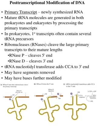
Download

1 / 42
420 likes | 565 Views
Manual modification of shape files. Basin Customization 03-2 March 2003. Reasons for Modification. Correct minor delineation errors. Add additional attributes to data table. Define watersheds smaller than the NSSL basins, mainly in highly urbanized areas.

E N D
Manual modification of shape files Basin Customization 03-2 March 2003
Reasons for Modification • Correct minor delineation errors. • Add additional attributes to data table. • Define watersheds smaller than the NSSL basins, mainly in highly urbanized areas. • Segment NSSL watersheds for improved detection + upstream-downstream timing. • Add point data sets for rain or stream gages.
Error Checking? • Compare EPA River Reach or NHD streams with defined NSSL watersheds. • Streams should cross ridge line boundaries only at outflow point. • Do watershed boundaries intersect the outflow point of a watershed? • Are radar bin assignments impacted by the error?
Shapefile attributes NSSL CD
Aggregated watersheds 8,000 –12,000 per WSR-88D Kpbz_agg_basins-French Creek Shape Polygon PFAF_ID 1461211000000 HUC 5010004 X_Outlet -79.82031 Y_Outlet 41.39202 State PA CWA PBZ CountyName Venango FIPS 42121 RFC OHRFC Modified 0 Reservoir 0 Area_sq_mi 5.59 Flow_acc 891 X_Centroid -79.85037 Y_Centroid 41.40212 French Creek Allegheny River Franklin, PA
WSR-88D Polar Grid 1o by 1 km Shape point Azimuth_dg 18.5 Range_km 102.5 X_coord -79.82816 Y_coord 41.40520 PFAF_ID 1461211000000 Franklin, PA
Add Arcview basin attributes? FFMP Basin ID Number Flash Flood Guidance Average Basin Rainfall (ABR) Basin Type??
New attribute: FFMP basin ID • Provides a link between the FFMP county threat table and the ArcView shapefiles provided on the NSSL CD. • The FFMP basin ID number will change if local modifications are made to the original NSSL data set, such as the addition of new or subdivided watersheds.
Average Basin Rainfall (ABR) • Add ABR as an ArcView attribute and rainfall can be displayed as a shapefile. • An ABR attribute must be added for each time period of rainfall for display. • Customized ABR legends can be created to accommodate any rainfall amount.
McMahon Creek Flash Flood04 June 2002 • Belmont county very flashy. 0 fatalities for this event, but 2 persons in the water were rescued from their camper as it washed downstream. • Pipe and Wegee Creeks, where 26 fatalities resulted during the 14 June 1990 flash flood near Shadyside, Ohio. (just south of McMahon Cr). • A small tributary of Wheeling Creek (Steep Run) produced a fatality on 28 June 1998 near Barton,OH. (just north of McMahon Cr)
New attribute: ffg (% urbanization) • Modify FFG based on % urbanization • FFG = TR + SM • TR = Threshold runoff (constant from RFC) • SM = ABR needed to initiate runoff based on soil moisture content. • New FFG = TR + SM (1.0-% urbanization) • Future load of FFMP will allow basin specific FFG.
New Attribute: watershed type • 1– flash flood watershed with inflow • 2 – flash flood watershed no inflow • 5 – lake or reservoir • 6 – sink • 7 – major river segment • 8 – major river segment with river forecast point as outflow.
NSSL Aggregated watersheds Allegheny River French Creek 5632 Franklin, PA Subdivide these watersheds
5624 French Creek Rocky Grove 2.44 5623 5632 2.56 Franklin Franklin 2.36 Chubb Run ABR (in) 21-22 June 2001 2330-0040 UTC Franklin Airport 5622 2.40 Allegheny River 5618 0 2km 1.65
French Creek 13th Street Liberty Street Area 1.0 mi2 MBA 2.0 mi2 Chubb Run 15th Street Route 62 Customization Add small watersheds Route 8 0 1km Franklin Airport
Customization…Add urban areas. French Creek Rocky Grove 7795 5632 Franklin Franklin Airport 0 2km
Area 14.8 mi2 Whiskey Run Carnegie Stream gage
Carnegie Stream gage
Sources of additive information • Mapping software showing detailed street information can be very valuable. • Topographic Maps are available in both hard copy and on line show valuable information on land use including forests, urbanized areas etc.
7.5 Minute Topographic Maps • ftp ftpnssl.nssl.noaa.gov • cd /pub/ajones • get metadata.tar.gz • Download this national index of topos. • Topograpic maps an important source of information on urbanization.
Divide Moon Run For road crossing at McKees Rocks Road
Divide Little Pine Creekto increase early detection capability
Little Pine #1638 Creek Watershed 6.2 mi2 5.70 3631 2.4 mi2 7.09 3630 1.7 mi2 1-hour FFG 2.10 in 6.35 ABR (in) 30 May 1986 1930 –2130 UTC 3629 2.1 mi2 3.55 Pine Creek Stream gage At Etna, PA
Little Pine Creek at Etna, PA 30 May 1986 ABR #1638 FFG (2.1) = TR (.75) + SM (1.35) FF0 Time (UTC) FF = ABR - FFG FF0 (ABR – FFG = 0.0)
Little Pine Creek at Etna, PA 30 May 1986 ABR #1638 FFG (2.1) = TR (.75) + SM (1.35) FF1 Time (UTC) FF = ABR - FFG FF1 (ABR - FFG = 1.0)
Little Pine Creek at Etna, PA 30 May 1986 ABR #1638 FFG (2.1) = TR (.75) + SM (1.35) FF2 Time (UTC) FF = ABR - FFG FF2 (ABR - FFG = 2.0)
Little Pine Creek at Etna, PA 30 May 1986 ABR #1638 FFG (2.1) = TR (.75) + SM (1.35) FF Max 3.6 FF3 Time (UTC) FF = ABR - FFG FF3 (ABR - FFG = 3.0)
Head. Little Pine Creek #3631 30 May 1986 Area:2.4 mi2 Time UTC Bucket Survey maximum rainfall 8.00+ inches
Little Pine Creek at Etna, PA 30 May 1986 ABR FFG (2.1) = TR (.75) + SM (1.35) FF0 Time (UTC) FF = ABR - FFG FF0 (ABR – FFG = 0.0)
Little Pine Creek at Etna, PA 30 May 1986 ABR FFG (2.1) = TR (.75) + SM (1.35) FF1 Time (UTC) FF = ABR - FFG FF1 (ABR – FFG = 1.0)
Little Pine Creek at Etna, PA 30 May 1986 ABR FFG (2.1) = TR (.75) + SM (1.35) FF2 Time (UTC) FF = ABR - FFG FF2 (ABR – FFG = 2.0)
Little Pine Creek at Etna, PA 30 May 1986 ABR FFG (2.1) = TR (.75) + SM (1.35) FF3 Time (UTC) FF = ABR - FFG FF3 (ABR – FFG = 3.0)
Little Pine Creek at Etna, PA 30 May 1986 ABR FFG (2.1) = TR (.75) + SM (1.35) FF4 Time (UTC) FF = ABR - FFG FF4 (ABR – FFG = 4.0)
Little Pine Creek at Etna, PA 30 May 1986 ABR FFG (2.1) = TR (.75) + SM (1.35) FF Max 5.0 FF5 Time (UTC) FF = ABR - FFG FF5 (ABR – FFG = 5.0)
AMBER ABR 30 May 1986 1930- 2130 UTC FFMP # 1638 Little Pine Creek Watershed 6.2 mi2 5.70 3631 2.4 mi2 7.09 3630 1.7 mi2 Flood Peak 2130Z 1-hour FFG 2.10 6.35 FF: #1638 # 3631 FF0 2035Z 2000Z FF1 2050Z 2015Z FF2 2110Z 2030Z FF3 2120Z 2040Z FF4 ----- 2055Z FF5 ----- 2110Z 3629 2.1 mi2 3.55 Pine Creek
Subdivide for important urban locations Schools, hospitals, factories, residences at special risk.
Customization Summary • Tailor the data set to your flash flood risks. • Exclude areas not at risk (lakes, major river segments, high infiltration areas, swamps). • Add more detail in your urban areas (smaller streams and defined urban areas). • Add point data for additional information (rain gages, stream gages and river gages).