Download
1 / 41
410 likes | 422 Views
Inner structure of cities. dr. Jeney László Senior lecturer jeney@elte.hu. Economic Foundations of Local Development Module 1/b: Urban and Rural development by sectors Autumn term 2015/2016. CUB Department of Economic Geography and Futures Studies. Antecedent: von Thünen’s theory.

E N D
Inner structure of cities dr. Jeney László Senior lecturer jeney@elte.hu Economic Foundations of Local Development Module 1/b: Urban and Rural development by sectors Autumn term 2015/2016. CUB Department of Economic Geography and Futures Studies
Antecedent: von Thünen’s theory • Johann-Heinrich von Thünen • 1738–1850 • North German (Mecklenburg) landowner • Prominent nineteenth century economist • He sought to determine the most profitable land use for his estate • He collected information that would later be published in Der isolierteStaat (1826) • He developed one of the first models to describe the land use practices radiating out from a central market location
Background of Isolated State: Mecklenburg in early 1800s • Germany was made up of many states (kingdoms, empires, principalities, dukedoms, etc.) • E. g. Prussia, Saxony, Hessen, Mecklenburg, Württemberg, The Thuringian States, The Helvetian Republic • Before the age of the rise of the German customs-union ("Zollverein„) these states were isolated
Conditions of Thünen’s theory • Model of agricultural land use (created before industrialization) • Basic simplifying, limiting assumptions: • Central market with given prices. City with this market place is located centrally within what is referred to as an "Isolated State", suggesting a community that is self sufficient and has no external influences • ‚Isolated State’ is surrounded by wilderness: an unoccupied, unused land • Given production methods & costs for any crop independent of location (uniform technologies & no scale economies). Land is completely homogenous, flat, having no rivers, mountains or other obstructions. Furthermore, the soil quality, climate and all other factors on agriculture are the same • Linear transport cost/distance functions. There are no major roads of transportation. That is to say that the farmers transport their own products to the market via oxcart, across land, directly to the central marketplace • Farmers behave rationally to maximize profits in the marketplace
Innovation: the land use model • Several rings of agricultural land use practices would surround the central market place • Land within the closest ring around the market will produce products that are profitable in the market, yet are perishable or difficult to transport • As the distance from the central market increases, the land use shifts to producing products that are less profitable in the market, yet are much easier to transport 5
Balancing land use practices and transportation costs • Adam Smith's idea of ‚economic man’: the farmer is expected to maximize his profit (‚economic rent’) from his farmland • Profit at the central market depends on • Market value of the product • Transportation costs to get the product to the market • Cost, market value of products • High: dairy products and fresh vegetables (tomatoes etc.) • Low: grain or livestock • As the distance from the central market increases, the profit that would be gained from a product decreases • If the producer of ‚land use 1’ needed to transport the product 5 miles, there would be no profit made at the market • Rate of depreciation in market value varies with different land use types • If the farmer had land 4 miles from the market it would be more profitable to produce ‚land use 2’ • An equilibrium is met where the profit of one land use outweighs the profit of another (at this point the land use changes)
Basics of the theory of marginal productivity in a mathematically rigorous way • Locational rent (equivalent to land value): maximum amount a farmer could pay for using the land, without making losses • L = Y(P − C) − YDF • L = locational rent (in DM/km2) • Y = yield per unit of land (in t/km2) • P = market price per unit of commodity (in DM/t) • C = production cost per unit of commodity (in DM/t) • D = Distance from the market (in km) • F = Transport cost (in DM/t/km) • If Y=1000, P=100, C=50, and F=1 • At the market: L=50000 • 10 km: L = 40000 • 30 km: L = 20000
From ‚economic man’ to ‚economic rent’ • Adam Smith's idea of ‚economic man’: the farmer is expected to maximize his profit (‚economic rent’) from his farmland • Farmers of these products compete against each other, plant their crops concentrically around the market according to the locational rent curves of their own crops • Products having low yields with high price and high transport costs relative to its weight or distance due to its weight, will have higher locational rent close to the market than a product having lower transport costs • Locational rent is the highest possible amount one will pay for the use of the land for a certain cultivation, and is a relative indicator of competitiveness of it in the market
Land use – competitive agricultural products • For each product there is a certain distance from the city where its production would be worthwhile
Development of the Thünen-cirles • Circular land use zones (Thünen rings) • Transport costs are referred directly to the market (‚Luftlinie’) 10
Model of agricultural land use: the Thünen rings • Black dot: city • 4 concentric rings of agricultural activity • Dairy and market gardening, intensive farming: vegetables, fruit, milk and other dairy products must get to market quickly • Forest (timber and firewood would be produced for fuel and building materials): wood was a very important fuel for heating and cooking and is very heavy and difficult to transport • Extensive fields crops (grain etc.): grains last longer than dairy products and are much lighter than fuel, reducing transport costs • Ranching: animals are self-transporting, they can walk to the central city for sale or for butchering • Outer area: wilderness where agriculture is not profitable: too great a distance from the central city for any type of agricultural product
Weaknesses of the model • Differences in local physical conditions aren’t taken into consideration • Differential transportation costs (boats are the cheapest mode of transportation etc.) • Variations in topography • Soil fertility • Changes in demand or price of the commodity • Government policies • World has changed • City ports, railway stations • Tourist attractions • Quality of life, weather • Ethnic concentrations • People who are ALREADY there / prior land uses / history • Brownfields and pollution • Land sprawl as population grows: farms suburbs
The real World and modifications • Circular pattern • Only one market • Including transportation routes, the land use zones would be stripe-formed • What happens when we relax the assumptions? • Introduce another (competing) market centre • Introduce a transportations corridor
Shift from local isolation to regional integration • Break down somewhat in industrial and post-industrial economies as urban expansion/sprawl occur • Development of faster transportation • Modern refrigerators enable perishable products to be transported longer distances
Applications of Thünen’s approach today • Useful for economic history of Europe and European colonialism before the Industrial Revolution (Fernand Braudel's Civilization and Capitalism) • Idea of an "isolated state" is archaic in today's world • But agricultural patterns in Europe and the US still reflect the economic considerations that influenced von Thünen • Central to modern applications • Urban land use patterns (Alonso, 1964) Urban sprawl (Sinclair, 1967) • Other spatial studies where transportation costs have an influence over decisions on land use • Illustrated the use of distance-based gradient analysis • E. g.: the change in value for a variable such as land rent with increasing distance from the city centre • Foreshadowed research on optimization in land allocation to maximize the net return associated with landuse activities
Subsequent contributor of the concept: Alonso's Bid Rent Function • Publication: Location and Land Use, 1964. • Objective: optimal distances of residential and commercial land uses from CBD • Assumption: mono-centric city • The bid price function for the urban firm would be defined as follows: • It describes the prices which the firm is willing to pay at different locations (distances from the city centre) in order to achieve a certain level of profits.
Alonso: application of urban model – location rents Location Rent Industrial Residential Agricultural Distance from Center Commercial
Concentric model of urban land use Urban rent prices – CBD Hong Kong 20
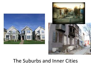
Inner structure of cities Friedrich Engels (1845): state of working class in England Richard Hurd (1903) Principles of City Land Values 22
Population change of Chicago, 1831–1930 residents 23
„L” tracks Concentric model of Burgess & Park (1925) • Concentric zones of urban land use • CBD (Central Business District): Loop tracks of elevated railroads, skyscrapers, turism • Zone in transition: mid 19th cent., strong ageing, inner industrial, outer residential zone • Zone of industrial workingmen’s homes: late 19th cent., tenement houses with 2 flats • Middle- (apartment houses) and high-class residential zone (single family dwellings) • Commuters zone: suburban settlements • Agricultural zone: supplier belt • Gravitation zone: hinterland of metropolis 24
Sectoral model of Hoyt (1939) • Location of the high-rent residental areas • Based on the model of Burgess • For 64 American cities, 3 dates • Results • Sectors instead of concentric circles • Sectors are separated from each other by the avenues • Sectors are moving towards the edge of the cities on a long run (suburbanization) • Urban districts/sectors: • CBD • Wholesale, light industry • Low-class residential • Middle-class residential • High-class residential 25 25
Policentric model of Harris & Ullman (1945) • Parts of cities: • CBD • Wholesale, light industry • Low-class residential • Middle-class residential • High-class residential • Heavy manufacturing • Outlying business district • Residential and industrial suburbs • Outer centres besides the CBD 26
Hungarian cases: functional – morphological structure of Budapest and the mid-size towns Block of flats Other clear area Zone of farmsteads Closed built-up residential quarter Mixed (industrial–residential) Family dwellings Budapest Towns of the Great Hungarian Plain 27
Urban concept General characteristics of the towns: Their role (functions): ‚important’ places Their demographic features: larger population number, population density, heterogeneous society Image: suiting to the crowd Lack of unified official definition of the concept of the towns, it varies: In space: geographic places/cultures In time: historical periods In different disciplines 29
1. Geographic differences of the concept of the town Towns with different size in different societies, depending on: Natural resources Available material for buildings Form of economy Basis of urban–rural separation differs Less developed countries: agriculture is still determinant basis is the economic structure (weight of agriculture) Developed world: agriculture is not determinant in villages basis is the population density Critical population number is different in different countries for definition of the towns Scandinavia: 200 residents Some Asian countries: more 10 thousand residents 30
2. Dinamic change of the concept of the town – long term Features of the feudal towns: Wall of the town For the security of the seats Etimologically: castle citizen / German (‚Burg’ ‚Bürger’), Hungarian (‚vár’ ‚város’) Visible element of the image of the towns Free rights Paradoxon: citizens behind the walls are more free Independence from the landlords: ‚Stadtluftmachtfrei’ Society of the Middle Ages: big importance of the additional city rights: taxes, trade, judgement 31
2. Dinamic change of the concept of the town – short term Features of the modern towns: Decreasing significance of the walls of the towns Towns exceeds the limits of its walls Walls are unable to defend in the Modern Ages Crowd high density + growing buildings (high rise buildings) visible element of the image of the towns (instead of walls) More civil society decreasing significance of the additional rights Lack of Middle Ages in the New World: critical population number (instead of royal city rights) Globalization, consuming society consuming culture is determinant 32
2. Dinamic change of the concept of the town – short term Hungarian practise in definition of towns Socialism: advantages of city right less new towns Better position at state supports Institution, location of higher level of council and party organisations 1970: smallest town (Szigetvár) – app. 10 thousand residents 1985: cancellation of the State Settlement-development Concept, settlement policy is facing towards the disadvantageous areas easier way of getting the urban right ‚urban boom’ (2012: 328) 2012: 185 towns below 10 thousand residents, smallest one (Pálháza) – below 1 thousand residents decreasing average size of towns 33
3. Different approaches in different disciplines in definition of towns The disciplines dealing with towns are not unified Urban characteristics is different in various professional areas Geography: central functions Public administration: urban right Sociology: social distribution: multicultural + polarized Urban architecture/Urbanistics: more densely built settlement + high buildings 35
Characteristics of towns Their functions economic–functional urban concept Many-sided and central function within the settlement network Low significance of agriculture Their demographic features social–statistical urban concept Higher population number Higher population density Appearance image–urbanistic urban concept More crowded building structure Higher average floor number Their significance if different in various periods But: these remained urban feature currently as well 36
Megacities over 10 milion residents Europe: sub- and dezurbanization slower increase of cities not characteristic (only Istanbul and Moscow) Global peripheries: appearance of megacities (megapolises) parallel with the demographic explosion of the 20th century 37
Classification of the Hungarian cities by their population number, 2012 38
Urban and rural areas in the European Union according to the definition of the OECD • Predominantly urban regions: rural population less than 15% of the total population of the NUTS3 region • Intermediate regions: rural population between 15 and 50 % of the total population of the NUTS3 region • Predominantly rural regions: rural population is 50% or more of the total population of the NUTS3 region 39
Urban and rural areas in the European Union according to the definition of the EU • Predominantly urban regions: rural population less than 20% of the total population of the NUTS3 region • Intermediate regions: rural population between 20 and 50 % of the total population of the NUTS3 region • Predominantly rural regions: rural population is 50% or more of the total population of the NUTS3 region • This typology is based on a definition of urban and rural 1 km2 grid cells • Critical population density: 300 inhabitants per km2 • Critical population: 5000 res. 40
Tallest cities of the world (by the average height of their 10 tallest buildings) 41