Download
1 / 25
250 likes | 377 Views
Expected Long Term Site Evolution of Alameda Creek and former Salt Ponds following Tidal Marsh Restoration. Matt Wickland m.wickland@pwa-ltd.com Philip Williams & Associates. Presentation Summary.

E N D
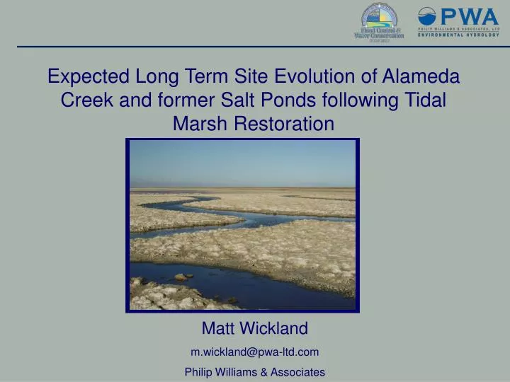
Expected Long Term Site Evolution of Alameda Creek and former Salt Ponds following Tidal Marsh Restoration Matt Wickland m.wickland@pwa-ltd.com Philip Williams & Associates
Presentation Summary Development of future channel and marsh plain conditions to better inform flood modeling of Alameda Creek and Old Alameda Creek using geomorphic design tools from similar tidal marsh restoration sites - Project overview- Development of long term site conditions - Hydrodynamic modeling application
Overview – Setting Downstream reach of the creekfrom Ardenwood Blvd to the BayMajor flood control facility designedby USACEConveyance capacity reduced by sedimentation
Overview – Project Goals Work with Alameda County to develop conceptual alternatives for the Eden Landing area that: 1 - Maintain or increase flood protection on Alameda Creek Flood Control Channel and Old Alameda Creek2 - Integrate with South Bay Salt Ponds restoration alternatives3 - Examine long term conditions ( ~50 years ) • Channel evolution • Marsh plain sedimentation • Sea Level Rise
Overview – SBSP Project Description • Each SBSP programmatic alternative integrates: • - habitat restoration • flood management • public access
Overview – SBSP Alternatives The SBSP programmatic alternatives are: • Alternative A: No Project Alternative • Alternative B: Mix of Tidal Habitat (50%) and Managed Pond (50%) • Alternative C: Mix of Tidal Habitat (90%) and Managed Pond (10%) Alternatives B and C are the same for the E2 pond complex
Supplemental Alternatives Short Term (development)- Breaches (internal and external levees) will maximize channel scour & are based on thehistoric channel networkLong Term (evolution)- Cross section and breach dimensions were estimated usinghydraulic geometry relationships- Restored marsh areas were assumed to increase in elevation to MHHW (w/ sea level rise)&develop channels based on historic channel network
Supplemental Alternatives Short Term (development)- Breaches (internal and external levees) will maximize channel scour& are based on thehistoric channel networkLong Term (evolution)- Cross section and breach dimensions were estimated usinghydraulic geometry relationships- Restored marsh areas were assumed to increase in elevation to MHHW (w/ sea level rise)&develop channels based on historic channel network
Water level decreases Floodplain storage and conveyance increase Scour enlarges channel Scour Immediately After Construction Sedimentation reduces conveyance & storage Flood control channel Salt pond Existing Condition Scour Scour Long-term Tidal Scour and Fluvial Flooding • Levees separate channels from adjacent salt ponds • Channels fill in with sediment and salt ponds subside • Levee lowering/ removal causes channel scour and marsh sedimentation • Salt pond restoration can reduce fluvial flood hazards through increased conveyance
Tidal Scour Sonoma Baylands Main Channel 1996 Tidal prism = 1 million ft3 2004 Tidal prism = 26 million ft3
Levee Breach Locations Historic channels were used to locate breaches
Levee Breach Locations Supplemental Alternative 1
Levee Breach Locations Supplemental Alternative 2
Levee Breach Locations Supplemental Alternative 3
Supplemental Alternatives Short Term (development)- Breaches (internal and external levees) will maximize channel scour & are based on thehistoric channel networkLong Term (evolution)- Cross section and breach dimensions were estimated usinghydraulic geometry relationships- Restored marsh areas were assumed to increase in elevation to MHHW (w/ sea level rise)&develop channels based on historic channel network
Cross Section Development What is hydraulic geometry? A set of empirical geomorphic relationships that predict tidal channel cross section dimensions as a function of contributing marsh area or tidal prism • Developed for SF Bay- Marshes from 2 to 5,700 ha- Design tool for restoration projects Williams, Orr, & Garrity (2002)
Cross Section Development Breach sizes were based on anticipated drainage areas (estimated from historic network and interior levee layout)
Cross Section Development Cross section example width MHHW depth
Restored Marsh Areas • Former salt ponds will eventually fill with sediment to the elevation ~MHHW (including sea level rise)- Sediment supply in South Bay is sufficient to fill former ponds PWA, 2006. South Bay Geomorphic Assessment. Prepared for California State Coastal Conservancy, US Fish & Wildlife Service, California Dept. of Fish and Game. Assumed sea level rise of 0.15 meters over 50 years
Restored Marsh Areas Long term bathymetry includes sedimentation, sea level rise, and estimated channel network (based on historic channels)
Hydrodynamic Modeling MIKE Flood: 1-D (MIKE 11) and 2-D (MIKE 21) models Connected through lateral and standard links 880 Ardenwood Blvd
Modeling Description Model runs - Short term, post breach conditions - no scour, no sedimentation - Long term, ‘worst case’ conditions - no scour, with sedimentation & sea level rise - Long term, most likely conditions - with scour, sedimentation, & sea level rise - Long term, no action conditions - with levee failures - with scour, sedimentation, & sea level rise
Model Results Reduction in peak water levels at Ardenwood Blvd - Larger channel dimensions - Reduction in flow (routed through salt ponds) Water surface and levee crest elevations DRAFT
Conclusion • Long term conditions should be considered in any design- Long term site geometry (channels and marshes) can be predicted from analogous tidal marsh restoration sites- Tidal marsh restoration can be beneficial to flood management and flood control
Questions?Thanks to: Alameda County Flood Control and Water Conservation District